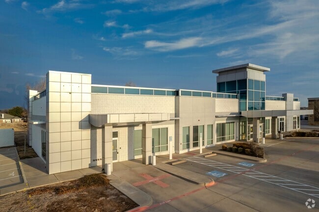
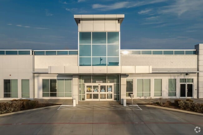
Property Record
8020 Matlock Rd, Arlington, TX 76002

Property Detail
8020 Matlock Rd
Dallas-Fort Worth-Arlington, TX
OWL CREEK ESTATES ADDITION BLOCK 1 LOT 32A
41281330
Tarrant
Commercialnec
Texas
B and X Area of moderate flood hazard, usually the area between the limits of the 100-year and 500-year floods.
32a
2024
1.34 AC
2025
SE Outlying Tarrant
111567
Dallas/Ft Worth
9,640 SF
NEARBY LISTINGS FOR SALE OR LEASE
DEMOGRAPHICS near 8020 Matlock Rd
1 mile
3 mile
5 mile
2025 Total Population
18,789
114,945
245,338
2030 Population
19,618
120,527
258,025
Pop Growth 2025-2030
+ 4.41%
+ 4.86%
+ 5.17%
Average Age
36
37
37
2025 Total Households
5,702
36,467
80,272
HH Growth 2025-2030
+ 4.61%
+ 5.07%
+ 5.36%
Median Household Inc
$105,531
$106,640
$103,363
Avg Household Size
3.20
3.10
3.00
2025 Avg HH Vehicles
2.00
2.00
2.00
Median Home Value
$354,356
$355,419
$358,926
Median Year Built
2004
2000
1999
Nearby Places
Map Layers
Map Styles
 Street
 Aerial
Transit
 Traffic
 Biking
Places
Listings with unknown addresses are not visible on the map
- Restaurants
- Banks
- Shops
- Fitness
- Groceries
PUBLIC TRANSPORTATION
AIRPORT
Dallas-Fort Worth International
Drive
Walk
Distance
Dallas-Fort Worth International
37 min
25.3 mi
Dallas Love Field
Drive
Walk
Distance
Dallas Love Field
47 min
33.3 mi
SALE & LEASE HISTORY
LISTING DATE
SALE/LEASE

Sep 30, 2019
For Lease
Sep 26, 2019
For Lease
Dec 15, 2023
For Lease
Nearby Properties
Address
Land Use
TOTAL SIZE
Lot Size
Zoning
Address
Land Use
TOTAL SIZE
Lot Size
Zoning
399,570 SF
75.21 AC
Address
Land Use
TOTAL SIZE
Lot Size
Zoning
324,849 SF
13.52 AC
Address
Land Use
TOTAL SIZE
Lot Size
Zoning
326,267 SF
13.11 AC
Address
Land Use
TOTAL SIZE
Lot Size
Zoning
352,649 SF
17.16 AC
Address
Land Use
TOTAL SIZE
Lot Size
Zoning
260,008 SF
139.37 AC
Address
Land Use
TOTAL SIZE
Lot Size
Zoning
348,951 SF
18.66 AC
Address
Land Use
TOTAL SIZE
Lot Size
Zoning
419,875 SF
108.14 AC
Address
Land Use
TOTAL SIZE
Lot Size
Zoning
160,000 SF
26.90 AC
Address
Land Use
TOTAL SIZE
Lot Size
Zoning
270,214 SF
17.85 AC
Address
Land Use
TOTAL SIZE
Lot Size
Zoning
298,988 SF
7.16 AC
Address
Land Use
TOTAL SIZE
Lot Size
Zoning
246,204 SF
15.16 AC
Address
Land Use
TOTAL SIZE
Lot Size
Zoning
258,908 SF
22.41 AC
Address
Land Use
TOTAL SIZE
Lot Size
Zoning
249,922 SF
17.26 AC
Address
Land Use
TOTAL SIZE
Lot Size
Zoning
255,134 SF
21.62 AC
Address
Land Use
TOTAL SIZE
Lot Size
Zoning
209,307 SF
15.34 AC
Address
Land Use
TOTAL SIZE
Lot Size
Zoning
77,038 SF
11.46 AC
Address
Land Use
TOTAL SIZE
Lot Size
Zoning
208,630 SF
8.62 AC
Address
Land Use
TOTAL SIZE
Lot Size
Zoning
231,551 SF
25.69 AC
Address
Land Use
TOTAL SIZE
Lot Size
Zoning
171,820 SF
59.63 AC
Address
Land Use
TOTAL SIZE
Lot Size
Zoning
98,664 SF
5.47 AC
Address
Land Use
TOTAL SIZE
Lot Size
Zoning
177,384 SF
28.68 AC
Address
Land Use
TOTAL SIZE
Lot Size
Zoning
182,763 SF
10.54 AC
Address
Land Use
TOTAL SIZE
Lot Size
Zoning
229,168 SF
6.13 AC
Address
Land Use
TOTAL SIZE
Lot Size
Zoning
399,496 SF
23.29 AC
Address
Land Use
TOTAL SIZE
Lot Size
Zoning
149,494 SF
3.73 AC
Address
Land Use
TOTAL SIZE
Lot Size
Zoning
663,733 SF
7.77 AC
Address
Land Use
TOTAL SIZE
Lot Size
Zoning
276,267 SF
16.10 AC
Address
Land Use
TOTAL SIZE
Lot Size
Zoning
92,456 SF
5.14 AC
Address
Land Use
TOTAL SIZE
Lot Size
Zoning
427,622 SF
24.26 AC
Address
Land Use
TOTAL SIZE
Lot Size
Zoning
160,000 SF
37.89 AC
The World's #1 Commercial Real Estate Marketplace
Connect with us
© 2026 CoStar Group
The information above has been obtained from sources believed reliable. While we do not doubt its accuracy we have not verified it and make no guarantee, warranty or representation about it. It is your responsibility to independently confirm its accuracy and completeness. Any projections, opinions, assumptions, or estimates used are for example only and do not represent the current or future performance of the property. The value of this transaction to you depends on tax and other factors which should be evaluated by your tax, financial, and legal advisors. You and your advisors should conduct a careful, independent investigation of the property to determine to your satisfaction the suitability of the property for your needs.