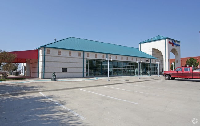
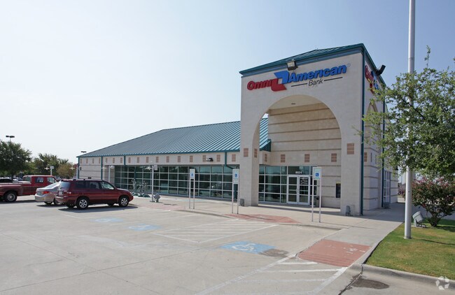
Property Record
8024 Denton Hwy, Watauga, TX 76148

Property Detail
8024 Denton Hwy
Dallas-Fort Worth-Arlington, TX
WATAUGA TOWNE CROSSING ADDN BLOCK A LOT 3
07611269
Tarrant
Commercialnec
Texas
B and X Area of moderate flood hazard, usually the area between the limits of the 100-year and 500-year floods.
3
2024
1.75 AC
2025
Watauga/Keller/NRH
113803
Dallas/Ft Worth
6,337 SF
NEARBY LISTINGS FOR SALE OR LEASE
DEMOGRAPHICS near 8024 Denton Hwy
1 mile
3 mile
5 mile
2025 Total Population
16,801
136,980
324,948
2030 Population
17,449
142,646
341,285
Pop Growth 2025-2030
+ 3.86%
+ 4.14%
+ 5.03%
Average Age
37
38
38
2025 Total Households
5,579
46,019
115,386
HH Growth 2025-2030
+ 4.00%
+ 4.29%
+ 5.21%
Median Household Inc
$102,880
$110,454
$102,688
Avg Household Size
3.00
2.90
2.80
2025 Avg HH Vehicles
2.00
2.00
2.00
Median Home Value
$343,984
$343,837
$370,963
Median Year Built
1996
1994
1999
Nearby Places
Map Layers
Map Styles
 Street
 Aerial
Transit
 Traffic
 Biking
Places
Listings with unknown addresses are not visible on the map
- Restaurants
- Banks
- Shops
- Fitness
- Groceries
PUBLIC TRANSPORTATION
COMMUTER RAIL
Drive
Walk
Distance
16 min
9.5 mi
AIRPORT
Dallas-Fort Worth International
Drive
Walk
Distance
Dallas-Fort Worth International
31 min
17.6 mi
Dallas Love Field
Drive
Walk
Distance
Dallas Love Field
43 min
30.9 mi
Nearby Properties
Address
Land Use
TOTAL SIZE
Lot Size
Zoning
Address
Land Use
TOTAL SIZE
Lot Size
Zoning
524,216 SF
18.59 AC
Address
Land Use
TOTAL SIZE
Lot Size
Zoning
354,787 SF
27.24 AC
Address
Land Use
TOTAL SIZE
Lot Size
Zoning
350,153 SF
19.73 AC
Address
Land Use
TOTAL SIZE
Lot Size
Zoning
327,325 SF
16.87 AC
Address
Land Use
TOTAL SIZE
Lot Size
Zoning
285,672 SF
19.20 AC
Address
Land Use
TOTAL SIZE
Lot Size
Zoning
293,939 SF
16.63 AC
Address
Land Use
TOTAL SIZE
Lot Size
Zoning
381,489 SF
16.39 AC
Address
Land Use
TOTAL SIZE
Lot Size
Zoning
301,972 SF
19.32 AC
Address
Land Use
TOTAL SIZE
Lot Size
Zoning
266,403 SF
16.67 AC
Address
Land Use
TOTAL SIZE
Lot Size
Zoning
261,579 SF
30.93 AC
Address
Land Use
TOTAL SIZE
Lot Size
Zoning
930,000 SF
99.51 AC
Address
Land Use
TOTAL SIZE
Lot Size
Zoning
248,166 SF
12.05 AC
Address
Land Use
TOTAL SIZE
Lot Size
Zoning
234,084 SF
14.49 AC
Address
Land Use
TOTAL SIZE
Lot Size
Zoning
245,684 SF
18.11 AC
Address
Land Use
TOTAL SIZE
Lot Size
Zoning
130,253 SF
17.92 AC
Address
Land Use
TOTAL SIZE
Lot Size
Zoning
197,860 SF
19.82 AC
Address
Land Use
TOTAL SIZE
Lot Size
Zoning
174,898 SF
10.28 AC
Address
Land Use
TOTAL SIZE
Lot Size
Zoning
199,121 SF
10.18 AC
Address
Land Use
TOTAL SIZE
Lot Size
Zoning
139,050 SF
19.76 AC
Address
Land Use
TOTAL SIZE
Lot Size
Zoning
135,344 SF
15.34 AC
Address
Land Use
TOTAL SIZE
Lot Size
Zoning
207,437 SF
15.20 AC
Address
Land Use
TOTAL SIZE
Lot Size
Zoning
143,402 SF
35.56 AC
Address
Land Use
TOTAL SIZE
Lot Size
Zoning
208,400 SF
15.60 AC
Address
Land Use
TOTAL SIZE
Lot Size
Zoning
295,107 SF
15.56 AC
Address
Land Use
TOTAL SIZE
Lot Size
Zoning
87,400 SF
10.16 AC
Address
Land Use
TOTAL SIZE
Lot Size
Zoning
271,887 SF
9.82 AC
Address
Land Use
TOTAL SIZE
Lot Size
Zoning
94,613 SF
5.31 AC
Address
Land Use
TOTAL SIZE
Lot Size
Zoning
101,054 SF
14.89 AC
Address
Land Use
TOTAL SIZE
Lot Size
Zoning
118,190 SF
15 AC
Address
Land Use
TOTAL SIZE
Lot Size
Zoning
55,958 SF
6.29 AC
The World's #1 Commercial Real Estate Marketplace
Connect with us
© 2026 CoStar Group
The information above has been obtained from sources believed reliable. While we do not doubt its accuracy we have not verified it and make no guarantee, warranty or representation about it. It is your responsibility to independently confirm its accuracy and completeness. Any projections, opinions, assumptions, or estimates used are for example only and do not represent the current or future performance of the property. The value of this transaction to you depends on tax and other factors which should be evaluated by your tax, financial, and legal advisors. You and your advisors should conduct a careful, independent investigation of the property to determine to your satisfaction the suitability of the property for your needs.