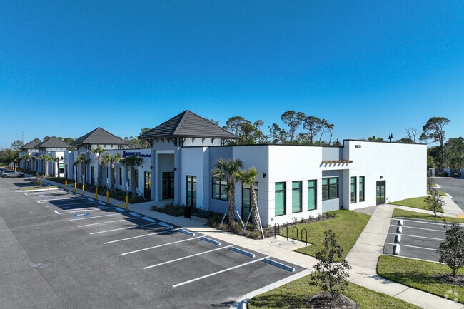
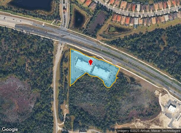
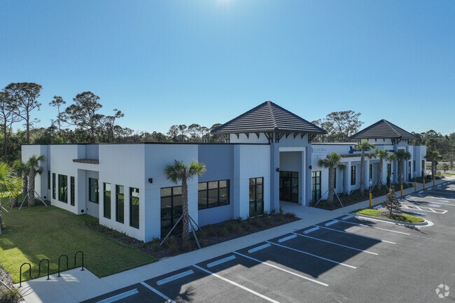
Property Record
8026 S Tamiami Trl, Venice, FL 34293
NEARBY LISTINGS FOR SALE OR LEASE
Property Detail
8026 S Tamiami Trl
North Port-Sarasota-Bradenton, FL
Wellen Park Vifiage E
0785-06-0100
TRACT 1, WELLEN PARK VILLAGE E, PB 55 PG 401-413, LESS LANDS AS DESC IN ORI 2022125559, BEING PORTION OF LANDS AS DESC IN ORI 2022008321
Medicalbuilding
Sarasota
2024
Florida
2025
3.35 AC
002731
Sarasota Outlying
32,230 SF
Tampa/St Petersburg
DEMOGRAPHICS near 8026 S Tamiami Trl
1 Mile
3 Mile
5 Mile
2024 Total Population
2,643
19,534
55,591
2029 Population
3,178
23,208
64,723
Pop Growth 2024-2029
+ 20.24%
+ 18.81%
+ 16.43%
Average Age
54
61
57
2024 Total Households
1,164
9,640
26,619
HH Growth 2024-2029
+ 20.27%
+ 18.67%
+ 16.47%
Median Household Inc
$117,125
$89,301
$76,268
Avg Household Size
2.30
2.00
2.00
2024 Avg HH Vehicles
2.00
2.00
2.00
Median Home Value
$396,601
$355,768
$329,137
Median Year Built
2011
2010
2001
Nearby Places
Map Layers
Map Styles
 Street
 Aerial
- Restaurants
- Banks
- Shops
- Fitness
- Groceries
PUBLIC TRANSPORTATION
AIRPORT
Punta Gorda
DRIVE
WALK
Distance
Punta Gorda
41 min
23.7 mi
Sarasota/Bradenton International
DRIVE
WALK
Distance
Sarasota/Bradenton International
50 min
36.2 mi
Freight Ports
Port Manatee
DRIVE
WALK
Distance
Port Manatee
62 min
48.7 mi
Nearby Properties
Address
Land Use
TOTAL SIZE
Lot Size
Zoning
Address
Land Use
TOTAL SIZE
Lot Size
Zoning
246,789 SF
80.41 AC
V
Address
Land Use
TOTAL SIZE
Lot Size
Zoning
357,609 SF
13.52 AC
V
Address
Land Use
TOTAL SIZE
Lot Size
Zoning
318,959 SF
7.24 AC
V
Address
Land Use
TOTAL SIZE
Lot Size
Zoning
285,151 SF
26.73 AC
V
Address
Land Use
TOTAL SIZE
Lot Size
Zoning
17,056 SF
118.25 AC
OUE1
Address
Land Use
TOTAL SIZE
Lot Size
Zoning
252,890 SF
9.15 AC
V
Address
Land Use
TOTAL SIZE
Lot Size
Zoning
125,619 SF
99.87 AC
GU
Address
Land Use
TOTAL SIZE
Lot Size
Zoning
155,979 SF
17.34 AC
V
Address
Land Use
TOTAL SIZE
Lot Size
Zoning
86,448 SF
11.15 AC
V
Address
Land Use
TOTAL SIZE
Lot Size
Zoning
85,177 SF
68.01 AC
RE1
Address
Land Use
TOTAL SIZE
Lot Size
Zoning
74,937 SF
354.80 AC
RSF2
Address
Land Use
TOTAL SIZE
Lot Size
Zoning
152.70 AC
AC8
Address
Land Use
TOTAL SIZE
Lot Size
Zoning
40,001 SF
7.67 AC
V
Address
Land Use
TOTAL SIZE
Lot Size
Zoning
11,328 SF
30 AC
V
Address
Land Use
TOTAL SIZE
Lot Size
Zoning
23,573 SF
69.06 AC
V
Address
Land Use
TOTAL SIZE
Lot Size
Zoning
106.85 AC
V
Address
Land Use
TOTAL SIZE
Lot Size
Zoning
51,671 SF
3.51 AC
V
Address
Land Use
TOTAL SIZE
Lot Size
Zoning
124.69 AC
V
Address
Land Use
TOTAL SIZE
Lot Size
Zoning
29.77 AC
V
Address
Land Use
TOTAL SIZE
Lot Size
Zoning
59.62 AC
V
Address
Land Use
TOTAL SIZE
Lot Size
Zoning
94.16 AC
V
Address
Land Use
TOTAL SIZE
Lot Size
Zoning
32,819 SF
4.53 AC
V
Address
Land Use
TOTAL SIZE
Lot Size
Zoning
54.08 AC
V
Address
Land Use
TOTAL SIZE
Lot Size
Zoning
24,206 SF
4.66 AC
V
Address
Land Use
TOTAL SIZE
Lot Size
Zoning
20,363 SF
5.57 AC
V
Address
Land Use
TOTAL SIZE
Lot Size
Zoning
81.06 AC
V
Address
Land Use
TOTAL SIZE
Lot Size
Zoning
20.36 AC
V
Address
Land Use
TOTAL SIZE
Lot Size
Zoning
49.42 AC
V
Address
Land Use
TOTAL SIZE
Lot Size
Zoning
17.18 AC
RMF3
The World's #1 Commercial Real Estate Marketplace
Connect with us
© 2026 CoStar Group
The information above has been obtained from sources believed reliable. While we do not doubt its accuracy we have not verified it and make no guarantee, warranty or representation about it. It is your responsibility to independently confirm its accuracy and completeness. Any projections, opinions, assumptions, or estimates used are for example only and do not represent the current or future performance of the property. The value of this transaction to you depends on tax and other factors which should be evaluated by your tax, financial, and legal advisors. You and your advisors should conduct a careful, independent investigation of the property to determine to your satisfaction the suitability of the property for your needs.