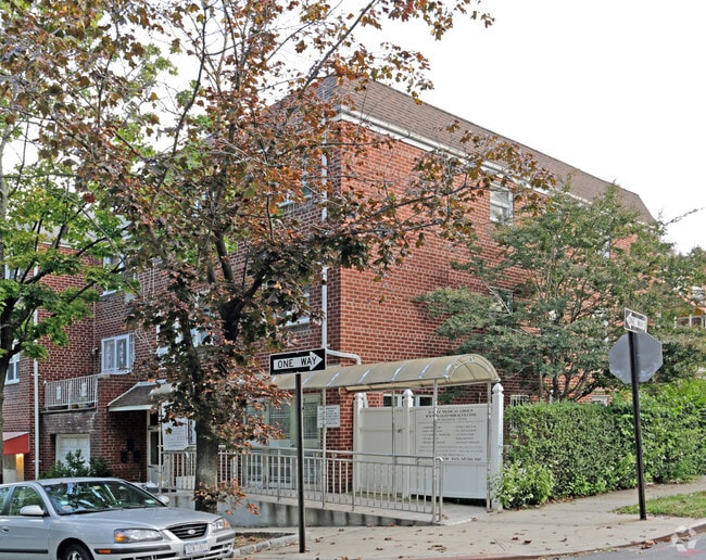
Property Record
8027 135Th St, Jamaica, NY 11435

NEARBY LISTINGS FOR SALE OR LEASE
Property Detail
8027 135Th St
06636-0063
Queens
Commercialofficeresidentialmixeduse
New York
X
63
3604970229F
0.04 AC
2024
South Queens
2025
Long Island (New York)
022001
New York-Jersey City-White Plains, NY-NJ
3,824 SF
DEMOGRAPHICS near 8027 135Th St
1 Mile
3 Mile
5 Mile
2024 Total Population
104,361
776,393
1,830,653
2029 Population
99,840
725,411
1,699,257
Pop Growth 2024-2029
(4.33%)
(6.57%)
(7.18%)
Average Age
42
41
41
2024 Total Households
41,498
264,772
613,519
HH Growth 2024-2029
(4.39%)
(6.59%)
(7.36%)
Median Household Inc
$82,964
$71,959
$69,962
Avg Household Size
2.40
2.80
2.80
2024 Avg HH Vehicles
1.00
1.00
1.00
Median Home Value
$522,751
$672,676
$673,209
Median Year Built
1953
1952
1952
Nearby Places
- Restaurants
- Banks
- Shops
- Fitness
- Groceries
PUBLIC TRANSPORTATION
TRANSIT/SUBWAY
Kew Gardens-Union Turnpike (E - New York MTA Subway (The Subway), F - New York MTA Subway (The Subway))
DRIVE
WALK
Distance
Kew Gardens-Union Turnpike (E - New York MTA Subway (The Subway), F - New York MTA Subway (The Subway))
5 min
9 min
0.5 mi
Briarwood-Van Wyck Boulevard (E - New York MTA Subway (The Subway), F - New York MTA Subway (The Subway))
DRIVE
WALK
Distance
Briarwood-Van Wyck Boulevard (E - New York MTA Subway (The Subway), F - New York MTA Subway (The Subway))
2 min
11 min
0.6 mi
75 Avenue (E - New York MTA Subway (The Subway), F - New York MTA Subway (The Subway))
DRIVE
WALK
Distance
75 Avenue (E - New York MTA Subway (The Subway), F - New York MTA Subway (The Subway))
4 min
17 min
0.9 mi
COMMUTER RAIL
Kew Gardens Station (Babylon Branch - Long Island Rail Road, Hempstead Branch - Long Island Rail Road, Long Beach Branch - Long Island Rail Road, Port Jefferson Branch - Long Island Rail Road)
DRIVE
WALK
Distance
Kew Gardens Station (Babylon Branch - Long Island Rail Road, Hempstead Branch - Long Island Rail Road, Long Beach Branch - Long Island Rail Road, Port Jefferson Branch - Long Island Rail Road)
3 min
13 min
0.7 mi
Forest Hills Station (Babylon Branch - Long Island Rail Road, Hempstead Branch - Long Island Rail Road, Long Beach Branch - Long Island Rail Road, Port Jefferson Branch - Long Island Rail Road)
DRIVE
WALK
Distance
Forest Hills Station (Babylon Branch - Long Island Rail Road, Hempstead Branch - Long Island Rail Road, Long Beach Branch - Long Island Rail Road, Port Jefferson Branch - Long Island Rail Road)
5 min
1.6 mi
AIRPORT
LaGuardia
DRIVE
WALK
Distance
LaGuardia
12 min
6.3 mi
John F Kennedy International
DRIVE
WALK
Distance
John F Kennedy International
10 min
6.8 mi
Newark Liberty International
DRIVE
WALK
Distance
Newark Liberty International
39 min
26.0 mi
Freight Ports
NY - Red Hook Container Terminal
DRIVE
WALK
Distance
NY - Red Hook Container Terminal
24 min
14.8 mi
SALE & LEASE HISTORY
LISTING DATE
SALE/LEASE

Mar 05, 2022
For Sale
Jun 23, 2022
For Sale
Apr 09, 2018
For Lease
Nearby Properties
Address
Land Use
TOTAL SIZE
Lot Size
Zoning
Address
Land Use
TOTAL SIZE
Lot Size
Zoning
4,528,000 SF
94.27 AC
R4
Address
Land Use
TOTAL SIZE
Lot Size
Zoning
2,078,606 SF
58.93 AC
R4
Address
Land Use
TOTAL SIZE
Lot Size
Zoning
1,258,350 SF
410.24 AC
PARK
Address
Land Use
TOTAL SIZE
Lot Size
Zoning
1,845,252 SF
172 AC
C8-1
Address
Land Use
TOTAL SIZE
Lot Size
Zoning
1,069,367 SF
14.65 AC
R4
Address
Land Use
TOTAL SIZE
Lot Size
Zoning
772,163 SF
5.24 AC
C4-5X
Address
Land Use
TOTAL SIZE
Lot Size
Zoning
54,170 SF
229.57 AC
PARK
Address
Land Use
TOTAL SIZE
Lot Size
Zoning
1,292,074 SF
C4-2F
Address
Land Use
TOTAL SIZE
Lot Size
Zoning
234,891 SF
3.17 AC
C4-5X
Address
Land Use
TOTAL SIZE
Lot Size
Zoning
1,516,458 SF
5.97 AC
R7-1
Address
Land Use
TOTAL SIZE
Lot Size
Zoning
532,011 SF
2.48 AC
R6
Address
Land Use
TOTAL SIZE
Lot Size
Zoning
15,000 SF
255.27 AC
PARK
Address
Land Use
TOTAL SIZE
Lot Size
Zoning
13,500 SF
104 AC
PARK
Address
Land Use
TOTAL SIZE
Lot Size
Zoning
126.85 AC
PARK
Address
Land Use
TOTAL SIZE
Lot Size
Zoning
4,800 SF
80.10 AC
PARK
Address
Land Use
TOTAL SIZE
Lot Size
Zoning
1,000 SF
210.07 AC
R3-2
Address
Land Use
TOTAL SIZE
Lot Size
Zoning
1,186,778 SF
31.45 AC
R4
Address
Land Use
TOTAL SIZE
Lot Size
Zoning
738,000 SF
1.92 AC
C6-3
Address
Land Use
TOTAL SIZE
Lot Size
Zoning
344,116 SF
0.92 AC
R7-1
Address
Land Use
TOTAL SIZE
Lot Size
Zoning
577,654 SF
5.38 AC
R6
Address
Land Use
TOTAL SIZE
Lot Size
Zoning
291,589 SF
1.55 AC
C6-3
Address
Land Use
TOTAL SIZE
Lot Size
Zoning
2,193 SF
94.72 AC
PARK
Address
Land Use
TOTAL SIZE
Lot Size
Zoning
521,944 SF
16.68 AC
R4
Address
Land Use
TOTAL SIZE
Lot Size
Zoning
360,000 SF
5.88 AC
C4-2
Address
Land Use
TOTAL SIZE
Lot Size
Zoning
307,038 SF
7.84 AC
M1-1
Address
Land Use
TOTAL SIZE
Lot Size
Zoning
234,452 SF
2.99 AC
R4
Address
Land Use
TOTAL SIZE
Lot Size
Zoning
490,600 SF
12.01 AC
M1-1
Address
Land Use
TOTAL SIZE
Lot Size
Zoning
320,535 SF
1.52 AC
C4-4A
Address
Land Use
TOTAL SIZE
Lot Size
Zoning
248,200 SF
1.25 AC
R6
Address
Land Use
TOTAL SIZE
Lot Size
Zoning
377,896 SF
11.36 AC
R3-2
The World's #1 Commercial Real Estate Marketplace
Connect with us
© 2025 CoStar Group
The information above has been obtained from sources believed reliable. While we do not doubt its accuracy we have not verified it and make no guarantee, warranty or representation about it. It is your responsibility to independently confirm its accuracy and completeness. Any projections, opinions, assumptions, or estimates used are for example only and do not represent the current or future performance of the property. The value of this transaction to you depends on tax and other factors which should be evaluated by your tax, financial, and legal advisors. You and your advisors should conduct a careful, independent investigation of the property to determine to your satisfaction the suitability of the property for your needs.