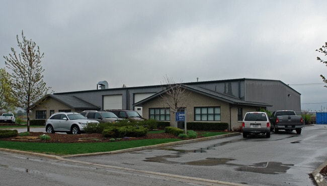
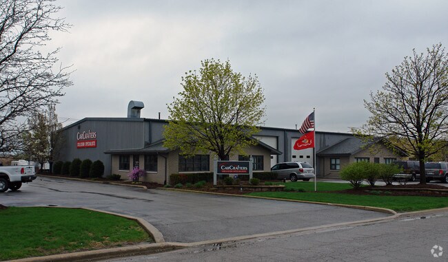
Property Record
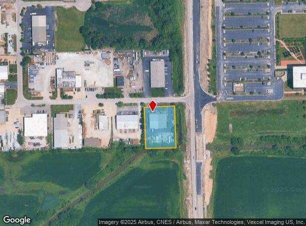
8027 189Th St, Mokena, IL 60448
NEARBY LISTINGS FOR SALE OR LEASE
Property Detail
8027 189Th St
Chicago-Naperville-Elgin, IL-IN
Industrial Center
19-09-02-401-013
LOT 12 IN 80TH AVE INDUSTRIAL CENTER, BEING A SUB OF PRT OF THE E1/2 OF THE SE1/4 OF SEC. 2, T35N-R12E.
Industrialgeneral
Will
A
Illinois
17197C0212G
12
2024
1.01 AC
2024
Joliet Area
824126
Chicago
8,768 SF
DEMOGRAPHICS near 8027 189Th St
1 Mile
3 Mile
5 Mile
2024 Total Population
3,760
62,185
168,021
2029 Population
3,724
60,954
164,236
Pop Growth 2024-2029
(0.96%)
(1.98%)
(2.25%)
Average Age
42
42
43
2024 Total Households
1,280
23,156
63,141
HH Growth 2024-2029
(0.86%)
(2.23%)
(2.56%)
Median Household Inc
$143,845
$102,857
$93,636
Avg Household Size
2.90
2.60
2.60
2024 Avg HH Vehicles
2.00
2.00
2.00
Median Home Value
$329,353
$279,937
$277,217
Median Year Built
2002
1990
1987
Nearby Places
Map Layers
Map Styles
 Street
 Aerial
- Restaurants
- Banks
- Shops
- Fitness
- Groceries
PUBLIC TRANSPORTATION
COMMUTER RAIL
Tinley Park - 80th Avenue Station (Rock Island District Line - Northeast Illinois Regional Commuter Railroad (Metra))
DRIVE
WALK
Distance
Tinley Park - 80th Avenue Station (Rock Island District Line - Northeast Illinois Regional Commuter Railroad (Metra))
5 min
1.5 mi
DRIVE
WALK
Distance
6 min
2.4 mi
AIRPORT
Chicago Midway International
DRIVE
WALK
Distance
Chicago Midway International
35 min
20.5 mi
Chicago O'Hare International
DRIVE
WALK
Distance
Chicago O'Hare International
58 min
39.3 mi
Nearby Properties
Address
Land Use
TOTAL SIZE
Lot Size
Zoning
Address
Land Use
TOTAL SIZE
Lot Size
Zoning
68,954 SF
Address
Land Use
TOTAL SIZE
Lot Size
Zoning
3,480,853 SF
Address
Land Use
TOTAL SIZE
Lot Size
Zoning
30.10 AC
Address
Land Use
TOTAL SIZE
Lot Size
Zoning
134,148 SF
5 AC
Address
Land Use
TOTAL SIZE
Lot Size
Zoning
79,455 SF
5.36 AC
Address
Land Use
TOTAL SIZE
Lot Size
Zoning
304,608 SF
19.51 AC
Address
Land Use
TOTAL SIZE
Lot Size
Zoning
168,708 SF
14.74 AC
Address
Land Use
TOTAL SIZE
Lot Size
Zoning
911,379 SF
51.23 AC
Address
Land Use
TOTAL SIZE
Lot Size
Zoning
173,415 SF
14.97 AC
Address
Land Use
TOTAL SIZE
Lot Size
Zoning
238,068 SF
13.96 AC
Address
Land Use
TOTAL SIZE
Lot Size
Zoning
200,815 SF
10 AC
Address
Land Use
TOTAL SIZE
Lot Size
Zoning
216,900 SF
10.11 AC
Address
Land Use
TOTAL SIZE
Lot Size
Zoning
280,313 SF
12.75 AC
Address
Land Use
TOTAL SIZE
Lot Size
Zoning
Address
Land Use
TOTAL SIZE
Lot Size
Zoning
23.67 AC
Address
Land Use
TOTAL SIZE
Lot Size
Zoning
8.50 AC
Address
Land Use
TOTAL SIZE
Lot Size
Zoning
77,290 SF
10.23 AC
Address
Land Use
TOTAL SIZE
Lot Size
Zoning
92,499 SF
5.29 AC
Address
Land Use
TOTAL SIZE
Lot Size
Zoning
113,474 SF
19.83 AC
Address
Land Use
TOTAL SIZE
Lot Size
Zoning
273,000 SF
20.69 AC
Address
Land Use
TOTAL SIZE
Lot Size
Zoning
77,779 SF
1.65 AC
Address
Land Use
TOTAL SIZE
Lot Size
Zoning
106,359 SF
8.25 AC
Address
Land Use
TOTAL SIZE
Lot Size
Zoning
40,000 SF
4.98 AC
Address
Land Use
TOTAL SIZE
Lot Size
Zoning
92,166 SF
23.83 AC
Address
Land Use
TOTAL SIZE
Lot Size
Zoning
8.76 AC
Address
Land Use
TOTAL SIZE
Lot Size
Zoning
70,848 SF
10.18 AC
Address
Land Use
TOTAL SIZE
Lot Size
Zoning
55,435 SF
6.43 AC
Address
Land Use
TOTAL SIZE
Lot Size
Zoning
113,936 SF
6.96 AC
Address
Land Use
TOTAL SIZE
Lot Size
Zoning
53,072 SF
0.63 AC
Address
Land Use
TOTAL SIZE
Lot Size
Zoning
97,318 SF
9.80 AC
The World's #1 Commercial Real Estate Marketplace
Connect with us
© 2026 CoStar Group
The information above has been obtained from sources believed reliable. While we do not doubt its accuracy we have not verified it and make no guarantee, warranty or representation about it. It is your responsibility to independently confirm its accuracy and completeness. Any projections, opinions, assumptions, or estimates used are for example only and do not represent the current or future performance of the property. The value of this transaction to you depends on tax and other factors which should be evaluated by your tax, financial, and legal advisors. You and your advisors should conduct a careful, independent investigation of the property to determine to your satisfaction the suitability of the property for your needs.