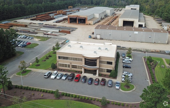
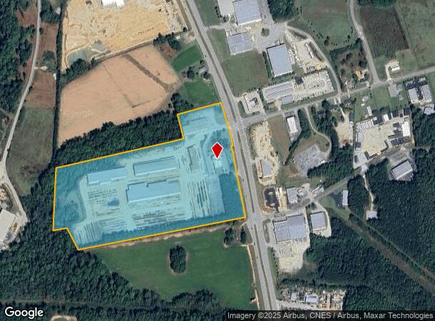
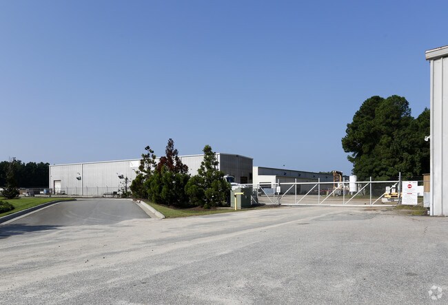
Property Record
8027 Clayton Blvd W, Clayton, NC 27520
NEARBY LISTINGS FOR SALE OR LEASE
-
-
View all Clayton listings for sale on LoopNet.com
Property Detail
8027 Clayton Blvd W
05I05038R
Recombination Plat Property Of Hales Inv
Heavymanufacturing
75/118 167700-40
X
Johnston
3720167700K
North Carolina
2025
30.80 AC
2025
Johnston County
040906
Raleigh/Durham
11,000 SF
Raleigh, NC
DEMOGRAPHICS near 8027 Clayton Blvd W
1 Mile
3 Mile
5 Mile
2024 Total Population
404
19,541
66,306
2029 Population
493
23,819
80,994
Pop Growth 2024-2029
+ 22.03%
+ 21.89%
+ 22.15%
Average Age
40
38
38
2024 Total Households
149
7,002
23,947
HH Growth 2024-2029
+ 22.15%
+ 22.08%
+ 22.30%
Median Household Inc
$89,655
$83,034
$74,494
Avg Household Size
2.70
2.70
2.70
2024 Avg HH Vehicles
2.00
2.00
2.00
Median Home Value
$295,744
$283,862
$273,419
Median Year Built
1997
2003
2003
Nearby Places
Map Layers
Map Styles
 Street
 Aerial
- Restaurants
- Banks
- Shops
- Fitness
- Groceries
PUBLIC TRANSPORTATION
AIRPORT
Raleigh-Durham International
DRIVE
WALK
Distance
Raleigh-Durham International
47 min
36.8 mi
Nearby Properties
Address
Land Use
TOTAL SIZE
Lot Size
Zoning
Address
Land Use
TOTAL SIZE
Lot Size
Zoning
29,088 SF
193.04 AC
IND
Address
Land Use
TOTAL SIZE
Lot Size
Zoning
71,773 SF
54.30 AC
IND
Address
Land Use
TOTAL SIZE
Lot Size
Zoning
25,200 SF
IND
Address
Land Use
TOTAL SIZE
Lot Size
Zoning
50,490 SF
IND
Address
Land Use
TOTAL SIZE
Lot Size
Zoning
99,977 SF
65.35 AC
IND
Address
Land Use
TOTAL SIZE
Lot Size
Zoning
84,568 SF
COM
Address
Land Use
TOTAL SIZE
Lot Size
Zoning
22,428 SF
19.98 AC
COM
Address
Land Use
TOTAL SIZE
Lot Size
Zoning
46,266 SF
19.36 AC
COM
Address
Land Use
TOTAL SIZE
Lot Size
Zoning
14,748 SF
114.84 AC
IND
Address
Land Use
TOTAL SIZE
Lot Size
Zoning
27,636 SF
17.81 AC
PUD
Address
Land Use
TOTAL SIZE
Lot Size
Zoning
64,644 SF
IND
Address
Land Use
TOTAL SIZE
Lot Size
Zoning
72,416 SF
6.61 AC
COM
Address
Land Use
TOTAL SIZE
Lot Size
Zoning
84,379 SF
6.87 AC
PUD
Address
Land Use
TOTAL SIZE
Lot Size
Zoning
2,217 SF
170.07 AC
IND
Address
Land Use
TOTAL SIZE
Lot Size
Zoning
17,000 SF
67.54 AC
RAG
Address
Land Use
TOTAL SIZE
Lot Size
Zoning
97,500 SF
3.96 AC
COM
Address
Land Use
TOTAL SIZE
Lot Size
Zoning
282,196 SF
139.44 AC
IND
Address
Land Use
TOTAL SIZE
Lot Size
Zoning
59,600 SF
29 AC
PUD
Address
Land Use
TOTAL SIZE
Lot Size
Zoning
85,840 SF
13.85 AC
IND
Address
Land Use
TOTAL SIZE
Lot Size
Zoning
99,500 SF
8.07 AC
IND
Address
Land Use
TOTAL SIZE
Lot Size
Zoning
57,701 SF
4.93 AC
COM
Address
Land Use
TOTAL SIZE
Lot Size
Zoning
54,968 SF
11.14 AC
PUD
Address
Land Use
TOTAL SIZE
Lot Size
Zoning
24,375 SF
6.55 AC
IND
Address
Land Use
TOTAL SIZE
Lot Size
Zoning
90,910 SF
10.33 AC
IND
Address
Land Use
TOTAL SIZE
Lot Size
Zoning
68,984 SF
6.66 AC
SUP
Address
Land Use
TOTAL SIZE
Lot Size
Zoning
31,452 SF
8.01 AC
IND
Address
Land Use
TOTAL SIZE
Lot Size
Zoning
69,115 SF
4.87 AC
IND
Address
Land Use
TOTAL SIZE
Lot Size
Zoning
41,632 SF
3.54 AC
IND
Address
Land Use
TOTAL SIZE
Lot Size
Zoning
14,300 SF
5.01 AC
PUD
The World's #1 Commercial Real Estate Marketplace
Connect with us
© 2025 CoStar Group
The information above has been obtained from sources believed reliable. While we do not doubt its accuracy we have not verified it and make no guarantee, warranty or representation about it. It is your responsibility to independently confirm its accuracy and completeness. Any projections, opinions, assumptions, or estimates used are for example only and do not represent the current or future performance of the property. The value of this transaction to you depends on tax and other factors which should be evaluated by your tax, financial, and legal advisors. You and your advisors should conduct a careful, independent investigation of the property to determine to your satisfaction the suitability of the property for your needs.