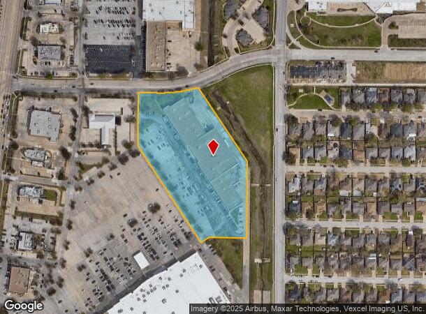
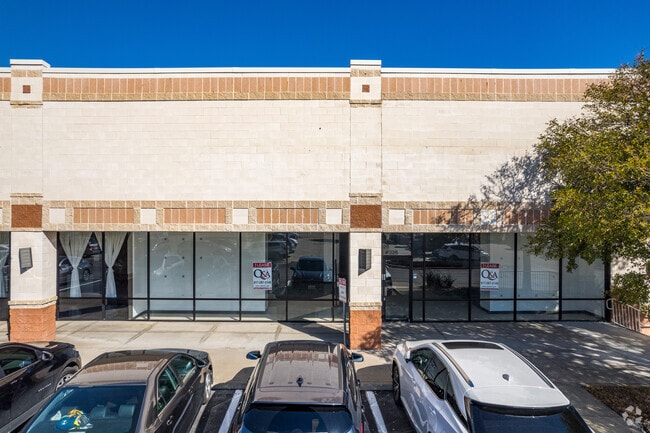
Property Record
8028 Denton Hwy, Watauga, TX 76148


NEARBY LISTINGS FOR SALE OR LEASE
Property Detail
8028 Denton Hwy
Dallas-Fort Worth-Arlington, TX
Watauga Towne Crossing Addn
07611196
WATAUGA TOWNE CROSSING ADDN BLOCK A LOT 1
Commercialnec
Tarrant
X
Texas
48121C0650G
1
2024
5.99 AC
2025
Watauga/Keller/NRH
113803
Dallas/Ft Worth
64,517 SF
DEMOGRAPHICS near 8028 Denton Hwy
1 mile
3 mile
5 mile
2024 Total Population
16,482
134,534
316,698
2029 Population
17,181
140,669
333,282
Pop Growth 2024-2029
+ 4.24%
+ 4.56%
+ 5.24%
Average Age
37
37
37
2024 Total Households
5,501
45,129
112,190
HH Growth 2024-2029
+ 4.22%
+ 4.61%
+ 5.31%
Median Household Inc
$92,200
$96,196
$92,274
Avg Household Size
2.90
2.90
2.80
2024 Avg HH Vehicles
2.00
2.00
2.00
Median Home Value
$261,459
$273,323
$295,716
Median Year Built
1994
1993
1998
Nearby Places
Map Layers
Map Styles
 Street
 Aerial
Transit
 Traffic
 Biking
Places
Listings with unknown addresses are not visible on the map
- Restaurants
- Banks
- Shops
- Fitness
- Groceries
PUBLIC TRANSPORTATION
COMMUTER RAIL
Drive
Walk
Distance
17 min
9.6 mi
AIRPORT
Dallas-Fort Worth International
Drive
Walk
Distance
Dallas-Fort Worth International
32 min
18.7 mi
Dallas Love Field
Drive
Walk
Distance
Dallas Love Field
43 min
30.8 mi
SALE & LEASE HISTORY
LISTING DATE
SALE/LEASE

Sep 25, 2016
For Lease
Nearby Properties
Address
Land Use
TOTAL SIZE
Lot Size
Zoning
Address
Land Use
TOTAL SIZE
Lot Size
Zoning
354,787 SF
27.24 AC
Address
Land Use
TOTAL SIZE
Lot Size
Zoning
350,153 SF
19.73 AC
Address
Land Use
TOTAL SIZE
Lot Size
Zoning
327,325 SF
16.87 AC
Address
Land Use
TOTAL SIZE
Lot Size
Zoning
285,672 SF
19.20 AC
Address
Land Use
TOTAL SIZE
Lot Size
Zoning
381,489 SF
16.39 AC
Address
Land Use
TOTAL SIZE
Lot Size
Zoning
368,751 SF
19.97 AC
Address
Land Use
TOTAL SIZE
Lot Size
Zoning
301,972 SF
19.32 AC
Address
Land Use
TOTAL SIZE
Lot Size
Zoning
266,403 SF
16.67 AC
Address
Land Use
TOTAL SIZE
Lot Size
Zoning
261,579 SF
30.93 AC
Address
Land Use
TOTAL SIZE
Lot Size
Zoning
930,000 SF
99.51 AC
Address
Land Use
TOTAL SIZE
Lot Size
Zoning
421,200 SF
73.51 AC
Address
Land Use
TOTAL SIZE
Lot Size
Zoning
248,166 SF
12.05 AC
Address
Land Use
TOTAL SIZE
Lot Size
Zoning
234,084 SF
14.49 AC
Address
Land Use
TOTAL SIZE
Lot Size
Zoning
245,684 SF
18.11 AC
Address
Land Use
TOTAL SIZE
Lot Size
Zoning
130,253 SF
17.92 AC
Address
Land Use
TOTAL SIZE
Lot Size
Zoning
197,860 SF
19.82 AC
Address
Land Use
TOTAL SIZE
Lot Size
Zoning
174,898 SF
10.28 AC
Address
Land Use
TOTAL SIZE
Lot Size
Zoning
199,121 SF
10.18 AC
Address
Land Use
TOTAL SIZE
Lot Size
Zoning
139,050 SF
19.76 AC
Address
Land Use
TOTAL SIZE
Lot Size
Zoning
208,143 SF
24.87 AC
Address
Land Use
TOTAL SIZE
Lot Size
Zoning
90,884 SF
10.85 AC
Address
Land Use
TOTAL SIZE
Lot Size
Zoning
88,000 SF
15.90 AC
Address
Land Use
TOTAL SIZE
Lot Size
Zoning
135,344 SF
15.34 AC
Address
Land Use
TOTAL SIZE
Lot Size
Zoning
86,000 SF
21.21 AC
Address
Land Use
TOTAL SIZE
Lot Size
Zoning
207,437 SF
15.20 AC
Address
Land Use
TOTAL SIZE
Lot Size
Zoning
143,402 SF
35.56 AC
Address
Land Use
TOTAL SIZE
Lot Size
Zoning
208,400 SF
15.60 AC
Address
Land Use
TOTAL SIZE
Lot Size
Zoning
295,107 SF
15.56 AC
Address
Land Use
TOTAL SIZE
Lot Size
Zoning
87,400 SF
10.16 AC
Address
Land Use
TOTAL SIZE
Lot Size
Zoning
271,887 SF
9.82 AC
The World's #1 Commercial Real Estate Marketplace
Connect with us
© 2026 CoStar Group
The information above has been obtained from sources believed reliable. While we do not doubt its accuracy we have not verified it and make no guarantee, warranty or representation about it. It is your responsibility to independently confirm its accuracy and completeness. Any projections, opinions, assumptions, or estimates used are for example only and do not represent the current or future performance of the property. The value of this transaction to you depends on tax and other factors which should be evaluated by your tax, financial, and legal advisors. You and your advisors should conduct a careful, independent investigation of the property to determine to your satisfaction the suitability of the property for your needs.