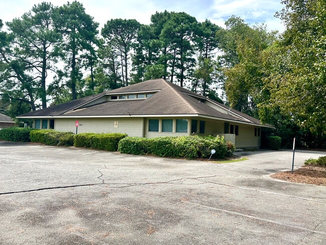
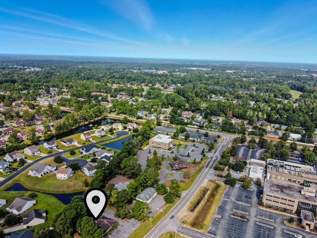
Property Record
8028 Myrtle Trace Dr, Conway, SC 29526

Save to a Folder
{{folder.Name}}
{{folder.ListingIds.length}} Properties
{{folder.ListingIds.length}} Property
Create a New Folder
Property Detail
8028 Myrtle Trace Dr
Myrtle Beach-Conway-North Myrtle Beach, SC
BURNING RIDGE MED PK; LOT 9
38315040004
Horry
Officebuilding
South Carolina
B and X Area of moderate flood hazard, usually the area between the limits of the 100-year and 500-year floods.
9
2025
0.51 AC
2025
Socastee/Red Hill
060405
Myrtle Beach/Conway
3,497 SF
NEARBY LISTINGS FOR SALE OR LEASE
DEMOGRAPHICS near 8028 Myrtle Trace Dr
1 mile
3 mile
5 mile
2025 Total Population
6,315
33,295
60,010
2030 Population
7,062
37,485
67,386
Pop Growth 2025-2030
+ 11.83%
+ 12.58%
+ 12.29%
Average Age
39
39
41
2025 Total Households
2,049
11,226
21,494
HH Growth 2025-2030
+ 11.86%
+ 12.62%
+ 12.24%
Median Household Inc
$71,460
$70,030
$73,548
Avg Household Size
2.30
2.30
2.40
2025 Avg HH Vehicles
2.00
2.00
2.00
Median Home Value
$296,284
$289,176
$309,055
Median Year Built
1996
1998
2000
Nearby Places
Map Layers
Map Styles
 Street
 Aerial
Layers
 Traffic
 Biking
Places
Listings with unknown addresses are not visible on the map
- Restaurants
- Banks
- Shops
- Fitness
- Groceries
PUBLIC TRANSPORTATION
AIRPORT
Myrtle Beach International
Drive
Walk
Distance
Myrtle Beach International
21 min
11.1 mi
SALE & LEASE HISTORY
LISTING DATE
SALE/LEASE

Sep 23, 2025
For Lease
May 22, 2026
For Lease
Jan 28, 2020
For Sale
Jan 26, 2020
For Lease
Feb 23, 2021
For Lease
Nearby Properties
Address
Land Use
TOTAL SIZE
Lot Size
Zoning
Address
Land Use
TOTAL SIZE
Lot Size
Zoning
32,016 SF
54.38 AC
Address
Land Use
TOTAL SIZE
Lot Size
Zoning
381,183 SF
42.78 AC
Address
Land Use
TOTAL SIZE
Lot Size
Zoning
747.28 AC
Address
Land Use
TOTAL SIZE
Lot Size
Zoning
24,024 SF
20.70 AC
Address
Land Use
TOTAL SIZE
Lot Size
Zoning
57,608 SF
11.54 AC
Address
Land Use
TOTAL SIZE
Lot Size
Zoning
96,796 SF
11.74 AC
Address
Land Use
TOTAL SIZE
Lot Size
Zoning
15,780 SF
14.74 AC
Address
Land Use
TOTAL SIZE
Lot Size
Zoning
11,409 SF
15.61 AC
Address
Land Use
TOTAL SIZE
Lot Size
Zoning
108,700 SF
7.97 AC
Address
Land Use
TOTAL SIZE
Lot Size
Zoning
62,019 SF
18.82 AC
Address
Land Use
TOTAL SIZE
Lot Size
Zoning
140,206 SF
24.62 AC
Address
Land Use
TOTAL SIZE
Lot Size
Zoning
164,424 SF
7.06 AC
Address
Land Use
TOTAL SIZE
Lot Size
Zoning
15,576 SF
24.74 AC
Address
Land Use
TOTAL SIZE
Lot Size
Zoning
45,090 SF
7.86 AC
Address
Land Use
TOTAL SIZE
Lot Size
Zoning
133,032 SF
12.56 AC
Address
Land Use
TOTAL SIZE
Lot Size
Zoning
31,788 SF
19.34 AC
Address
Land Use
TOTAL SIZE
Lot Size
Zoning
310,546 SF
11.98 AC
Address
Land Use
TOTAL SIZE
Lot Size
Zoning
28,400 SF
8.53 AC
Address
Land Use
TOTAL SIZE
Lot Size
Zoning
57.24 AC
Address
Land Use
TOTAL SIZE
Lot Size
Zoning
26.74 AC
Address
Land Use
TOTAL SIZE
Lot Size
Zoning
91,897 SF
25.13 AC
Address
Land Use
TOTAL SIZE
Lot Size
Zoning
83.80 AC
Address
Land Use
TOTAL SIZE
Lot Size
Zoning
26,832 SF
5.95 AC
Address
Land Use
TOTAL SIZE
Lot Size
Zoning
13,776 SF
6.79 AC
Address
Land Use
TOTAL SIZE
Lot Size
Zoning
68.50 AC
Address
Land Use
TOTAL SIZE
Lot Size
Zoning
131,858 SF
16.19 AC
Address
Land Use
TOTAL SIZE
Lot Size
Zoning
472.82 AC
Address
Land Use
TOTAL SIZE
Lot Size
Zoning
25,957 SF
9.85 AC
Address
Land Use
TOTAL SIZE
Lot Size
Zoning
69,720 SF
10.29 AC
The World's #1 Commercial Real Estate Marketplace
Connect with us
© 2026 CoStar Group
The information above has been obtained from sources believed reliable. While we do not doubt its accuracy we have not verified it and make no guarantee, warranty or representation about it. It is your responsibility to independently confirm its accuracy and completeness. Any projections, opinions, assumptions, or estimates used are for example only and do not represent the current or future performance of the property. The value of this transaction to you depends on tax and other factors which should be evaluated by your tax, financial, and legal advisors. You and your advisors should conduct a careful, independent investigation of the property to determine to your satisfaction the suitability of the property for your needs.