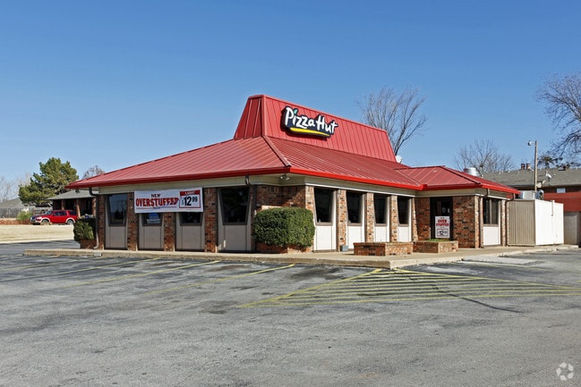
Property Record
803 N Main St, Noble, OK 73068


NEARBY LISTINGS FOR SALE OR LEASE
Property Detail
803 N Main St
Oklahoma City, OK
Northwoods
R0021542
NORTHWOODS LOTS 3-4 BLK 2
Restaurantbuilding
Cleveland
X
Oklahoma
40027C0295J
3
2024
1.13 AC
2024
Southeast Outlying
202502
Oklahoma City
2,816 SF
DEMOGRAPHICS near 803 N Main St
1 Mile
3 Mile
5 Mile
2024 Total Population
3,873
18,586
64,081
2029 Population
4,021
19,523
67,071
Pop Growth 2024-2029
+ 3.82%
+ 5.04%
+ 4.67%
Average Age
39
36
34
2024 Total Households
1,450
7,634
24,185
HH Growth 2024-2029
+ 4.00%
+ 5.07%
+ 5.03%
Median Household Inc
$60,703
$53,687
$49,770
Avg Household Size
2.60
2.30
2.30
2024 Avg HH Vehicles
2.00
2.00
2.00
Median Home Value
$163,201
$194,624
$198,155
Median Year Built
1986
2000
1990
Nearby Places
Map Layers
Map Styles
 Street
 Aerial
- Restaurants
- Banks
- Shops
- Fitness
- Groceries
PUBLIC TRANSPORTATION
COMMUTER RAIL
DRIVE
WALK
Distance
11 min
5.8 mi
AIRPORT
Will Rogers World
DRIVE
WALK
Distance
Will Rogers World
41 min
28.4 mi
SALE & LEASE HISTORY
LISTING DATE
SALE/LEASE

Aug 22, 2022
For Lease
Aug 22, 2022
For Lease
Nearby Properties
Address
Land Use
TOTAL SIZE
Lot Size
Zoning
Address
Land Use
TOTAL SIZE
Lot Size
Zoning
200,000 SF
40 AC
Address
Land Use
TOTAL SIZE
Lot Size
Zoning
18.55 AC
Address
Land Use
TOTAL SIZE
Lot Size
Zoning
30.44 AC
Address
Land Use
TOTAL SIZE
Lot Size
Zoning
3.07 AC
Address
Land Use
TOTAL SIZE
Lot Size
Zoning
2.76 AC
Address
Land Use
TOTAL SIZE
Lot Size
Zoning
21,641 SF
5.11 AC
Address
Land Use
TOTAL SIZE
Lot Size
Zoning
0.24 AC
Address
Land Use
TOTAL SIZE
Lot Size
Zoning
131,387 SF
9.55 AC
Address
Land Use
TOTAL SIZE
Lot Size
Zoning
54,160 SF
8.26 AC
Address
Land Use
TOTAL SIZE
Lot Size
Zoning
467,281 SF
33.50 AC
Address
Land Use
TOTAL SIZE
Lot Size
Zoning
351,466 SF
67.68 AC
I2
Address
Land Use
TOTAL SIZE
Lot Size
Zoning
367,145 SF
22.97 AC
Address
Land Use
TOTAL SIZE
Lot Size
Zoning
4.36 AC
Address
Land Use
TOTAL SIZE
Lot Size
Zoning
1,170 SF
11.36 AC
R1
Address
Land Use
TOTAL SIZE
Lot Size
Zoning
40.63 AC
Address
Land Use
TOTAL SIZE
Lot Size
Zoning
9.33 AC
Address
Land Use
TOTAL SIZE
Lot Size
Zoning
42,094 SF
18.75 AC
Address
Land Use
TOTAL SIZE
Lot Size
Zoning
107,526 SF
18.77 AC
Address
Land Use
TOTAL SIZE
Lot Size
Zoning
46,824 SF
1.45 AC
Address
Land Use
TOTAL SIZE
Lot Size
Zoning
384 SF
26.92 AC
PU
Address
Land Use
TOTAL SIZE
Lot Size
Zoning
234,051 SF
80.33 AC
Address
Land Use
TOTAL SIZE
Lot Size
Zoning
189,564 SF
20.33 AC
Address
Land Use
TOTAL SIZE
Lot Size
Zoning
2.76 AC
Address
Land Use
TOTAL SIZE
Lot Size
Zoning
147,692 SF
16.19 AC
Address
Land Use
TOTAL SIZE
Lot Size
Zoning
4,706 SF
11.03 AC
RM
Address
Land Use
TOTAL SIZE
Lot Size
Zoning
187,632 SF
11.25 AC
Address
Land Use
TOTAL SIZE
Lot Size
Zoning
198,416 SF
13.16 AC
Address
Land Use
TOTAL SIZE
Lot Size
Zoning
1.12 AC
Address
Land Use
TOTAL SIZE
Lot Size
Zoning
2.13 AC
Address
Land Use
TOTAL SIZE
Lot Size
Zoning
136,101 SF
8.76 AC
The World's #1 Commercial Real Estate Marketplace
Connect with us
© 2025 CoStar Group
The information above has been obtained from sources believed reliable. While we do not doubt its accuracy we have not verified it and make no guarantee, warranty or representation about it. It is your responsibility to independently confirm its accuracy and completeness. Any projections, opinions, assumptions, or estimates used are for example only and do not represent the current or future performance of the property. The value of this transaction to you depends on tax and other factors which should be evaluated by your tax, financial, and legal advisors. You and your advisors should conduct a careful, independent investigation of the property to determine to your satisfaction the suitability of the property for your needs.