Property Record
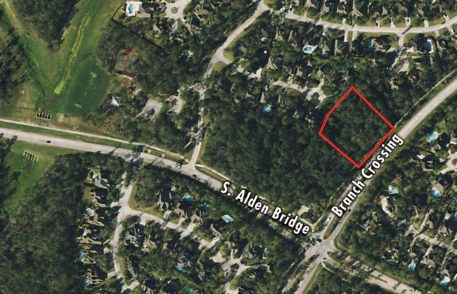
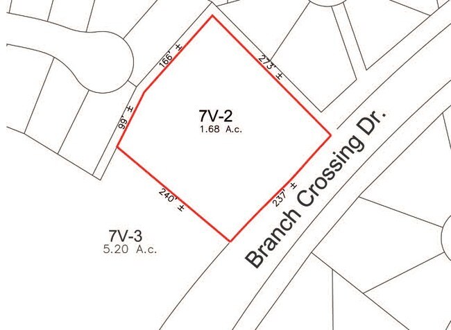
8030 Branch Crossing Dr, Spring, TX 77382

Property Detail
8030 Branch Crossing Dr
9719-58-13800
S971958 - WDLNDS VIL ALDEN BR 58, RES C, ACRES 1.52
Commercialnec
MONTGOMERY
6
Texas
B and X Area of moderate flood hazard, usually the area between the limits of the 100-year and 500-year floods.
1.52 AC
2024
The Woodlands
2025
Houston
690608
Houston-Pasadena-The Woodlands, TX
9,089 SF
NEARBY LISTINGS FOR SALE OR LEASE
DEMOGRAPHICS near 8030 Branch Crossing Dr
1 mile
3 mile
5 mile
2025 Total Population
9,225
70,029
147,189
2030 Population
10,663
81,220
170,354
Pop Growth 2025-2030
+ 15.59%
+ 15.98%
+ 15.74%
Average Age
40
39
39
2025 Total Households
3,191
24,733
53,151
HH Growth 2025-2030
+ 16.30%
+ 16.60%
+ 16.36%
Median Household Inc
$146,508
$141,939
$131,704
Avg Household Size
2.90
2.80
2.70
2025 Avg HH Vehicles
2.00
2.00
2.00
Median Home Value
$472,809
$496,331
$478,423
Median Year Built
2000
2003
2006
Nearby Places
Map Layers
Map Styles
 Street
 Aerial
Layers
 Traffic
 Biking
Places
Listings with unknown addresses are not visible on the map
- Restaurants
- Banks
- Shops
- Fitness
- Groceries
PUBLIC TRANSPORTATION
AIRPORT
George Bush Intcntl/Houston
Drive
Walk
Distance
George Bush Intcntl/Houston
41 min
29.0 mi
Freight Ports
Port of Houston
Drive
Walk
Distance
Port of Houston
64 min
44.8 mi
Nearby Properties
Address
Land Use
TOTAL SIZE
Lot Size
Zoning
Address
Land Use
TOTAL SIZE
Lot Size
Zoning
461,345 SF
28.36 AC
Address
Land Use
TOTAL SIZE
Lot Size
Zoning
370,029 SF
16.12 AC
Address
Land Use
TOTAL SIZE
Lot Size
Zoning
392,613 SF
19.35 AC
2
Address
Land Use
TOTAL SIZE
Lot Size
Zoning
361,747 SF
16.71 AC
Address
Land Use
TOTAL SIZE
Lot Size
Zoning
367,449 SF
7.78 AC
Address
Land Use
TOTAL SIZE
Lot Size
Zoning
296,538 SF
12.58 AC
Address
Land Use
TOTAL SIZE
Lot Size
Zoning
426,425 SF
8.74 AC
Address
Land Use
TOTAL SIZE
Lot Size
Zoning
295,608 SF
10.07 AC
6
Address
Land Use
TOTAL SIZE
Lot Size
Zoning
194,272 SF
11.06 AC
Address
Land Use
TOTAL SIZE
Lot Size
Zoning
289,611 SF
13.57 AC
Address
Land Use
TOTAL SIZE
Lot Size
Zoning
203,460 SF
39.49 AC
2
Address
Land Use
TOTAL SIZE
Lot Size
Zoning
222,687 SF
8.03 AC
2
Address
Land Use
TOTAL SIZE
Lot Size
Zoning
198,969 SF
32.78 AC
Address
Land Use
TOTAL SIZE
Lot Size
Zoning
141,496 SF
18.30 AC
2
Address
Land Use
TOTAL SIZE
Lot Size
Zoning
190,824 SF
3.62 AC
Address
Land Use
TOTAL SIZE
Lot Size
Zoning
153,063 SF
17.50 AC
Address
Land Use
TOTAL SIZE
Lot Size
Zoning
385,000 SF
68.27 AC
6
Address
Land Use
TOTAL SIZE
Lot Size
Zoning
139,140 SF
18.22 AC
6
Address
Land Use
TOTAL SIZE
Lot Size
Zoning
123,497 SF
18.77 AC
Address
Land Use
TOTAL SIZE
Lot Size
Zoning
13.76 AC
Address
Land Use
TOTAL SIZE
Lot Size
Zoning
107,000 SF
4.81 AC
Address
Land Use
TOTAL SIZE
Lot Size
Zoning
211,965 SF
25.17 AC
Address
Land Use
TOTAL SIZE
Lot Size
Zoning
76,599 SF
6.17 AC
Address
Land Use
TOTAL SIZE
Lot Size
Zoning
61,218 SF
9.30 AC
Address
Land Use
TOTAL SIZE
Lot Size
Zoning
172,784 SF
20.60 AC
2
Address
Land Use
TOTAL SIZE
Lot Size
Zoning
278,939 SF
13.76 AC
Address
Land Use
TOTAL SIZE
Lot Size
Zoning
5,044 SF
42.52 AC
6
Address
Land Use
TOTAL SIZE
Lot Size
Zoning
190,000 SF
24.21 AC
Address
Land Use
TOTAL SIZE
Lot Size
Zoning
165,218 SF
17.40 AC
2
Address
Land Use
TOTAL SIZE
Lot Size
Zoning
51,134 SF
25 AC
2
The World's #1 Commercial Real Estate Marketplace
Connect with us
© 2026 CoStar Group
The information above has been obtained from sources believed reliable. While we do not doubt its accuracy we have not verified it and make no guarantee, warranty or representation about it. It is your responsibility to independently confirm its accuracy and completeness. Any projections, opinions, assumptions, or estimates used are for example only and do not represent the current or future performance of the property. The value of this transaction to you depends on tax and other factors which should be evaluated by your tax, financial, and legal advisors. You and your advisors should conduct a careful, independent investigation of the property to determine to your satisfaction the suitability of the property for your needs.