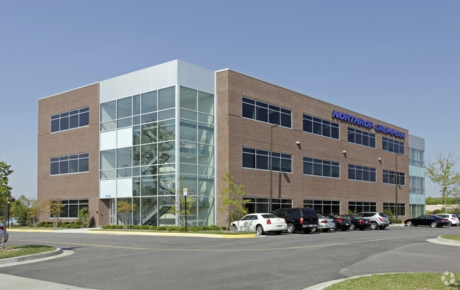
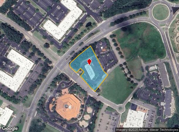
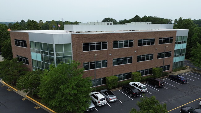
Property Record
8030 Harbour View Blvd, Suffolk, VA 23435
Current Lease Availabilities
NEARBY LISTINGS FOR SALE OR LEASE
Property Detail
8030 Harbour View Blvd
306002633
PAR.9C2,REPLAT PARC.9C, BRIDGEWAY COMMERCE PARK
Commercialnec
Suffolk City
X
Virginia
5155290018D
2.15 AC
2025
Harbourview/N Suffolk
2025
Hampton Roads
075105
Virginia Beach-Norfolk-Newport News, VA-NC
25,914 SF
DEMOGRAPHICS near 8030 Harbour View Blvd
1 Mile
3 Mile
5 Mile
2024 Total Population
2,167
37,947
77,973
2029 Population
2,393
39,977
82,093
Pop Growth 2024-2029
+ 10.43%
+ 5.35%
+ 5.28%
Average Age
43
37
39
2024 Total Households
861
14,933
30,079
HH Growth 2024-2029
+ 10.80%
+ 5.65%
+ 5.37%
Median Household Inc
$162,500
$74,264
$87,949
Avg Household Size
2.50
2.50
2.50
2024 Avg HH Vehicles
2.00
2.00
2.00
Median Home Value
$600,134
$272,626
$287,598
Median Year Built
2006
1991
1989
Nearby Places
Map Layers
Map Styles
 Street
 Aerial
- Restaurants
- Banks
- Shops
- Fitness
- Groceries
PUBLIC TRANSPORTATION
AIRPORT
Norfolk International
DRIVE
WALK
Distance
Norfolk International
31 min
17.1 mi
Newport News/Williamsburg International
DRIVE
WALK
Distance
Newport News/Williamsburg International
35 min
24.2 mi
Freight Ports
Virginia Port Authority - Newport News
DRIVE
WALK
Distance
Virginia Port Authority - Newport News
14 min
9.0 mi
Nearby Properties
Address
Land Use
TOTAL SIZE
Lot Size
Zoning
Address
Land Use
TOTAL SIZE
Lot Size
Zoning
2,400 SF
125.24 AC
HEAVY INDU
Address
Land Use
TOTAL SIZE
Lot Size
Zoning
13.52 AC
MIXED USE
Address
Land Use
TOTAL SIZE
Lot Size
Zoning
4,080 SF
41.46 AC
LIGHT INDU
Address
Land Use
TOTAL SIZE
Lot Size
Zoning
30.85 AC
PLANNED DE
Address
Land Use
TOTAL SIZE
Lot Size
Zoning
31,635 SF
10.36 AC
MIXED USE
Address
Land Use
TOTAL SIZE
Lot Size
Zoning
6,446 SF
8.76 AC
MIXED USE
Address
Land Use
TOTAL SIZE
Lot Size
Zoning
681,685 SF
52.59 AC
LIGHT INDU
Address
Land Use
TOTAL SIZE
Lot Size
Zoning
278,978 SF
26.63 AC
LIGHT INDU
Address
Land Use
TOTAL SIZE
Lot Size
Zoning
97,411 SF
17.90 AC
GENERAL CO
Address
Land Use
TOTAL SIZE
Lot Size
Zoning
46.66 AC
LIGHT INDU
Address
Land Use
TOTAL SIZE
Lot Size
Zoning
22,723 SF
10.97 AC
GENERAL CO
Address
Land Use
TOTAL SIZE
Lot Size
Zoning
166,481 SF
11.15 AC
OFFICE-INS
Address
Land Use
TOTAL SIZE
Lot Size
Zoning
287,348 SF
20.21 AC
URM
Address
Land Use
TOTAL SIZE
Lot Size
Zoning
43,917 SF
5.72 AC
MIXED USE
Address
Land Use
TOTAL SIZE
Lot Size
Zoning
15,746 SF
24.70 AC
GENERAL CO
Address
Land Use
TOTAL SIZE
Lot Size
Zoning
101,959 SF
12.65 AC
LIGHT INDU
Address
Land Use
TOTAL SIZE
Lot Size
Zoning
126,000 SF
21.51 AC
LIGHT INDU
Address
Land Use
TOTAL SIZE
Lot Size
Zoning
41,440 SF
6.60 AC
LIGHT INDU
Address
Land Use
TOTAL SIZE
Lot Size
Zoning
235,968 SF
13.25 AC
RMF1: MULT
Address
Land Use
TOTAL SIZE
Lot Size
Zoning
11,388 SF
153.71 AC
COMMERCE P
Address
Land Use
TOTAL SIZE
Lot Size
Zoning
165,034 SF
13.12 AC
URM
Address
Land Use
TOTAL SIZE
Lot Size
Zoning
6,788 SF
19.93 AC
GENERAL CO
Address
Land Use
TOTAL SIZE
Lot Size
Zoning
120,780 SF
10.20 AC
MIXED USE
Address
Land Use
TOTAL SIZE
Lot Size
Zoning
165,924 SF
13.70 AC
URM
The World's #1 Commercial Real Estate Marketplace
Connect with us
© 2025 CoStar Group
The information above has been obtained from sources believed reliable. While we do not doubt its accuracy we have not verified it and make no guarantee, warranty or representation about it. It is your responsibility to independently confirm its accuracy and completeness. Any projections, opinions, assumptions, or estimates used are for example only and do not represent the current or future performance of the property. The value of this transaction to you depends on tax and other factors which should be evaluated by your tax, financial, and legal advisors. You and your advisors should conduct a careful, independent investigation of the property to determine to your satisfaction the suitability of the property for your needs.