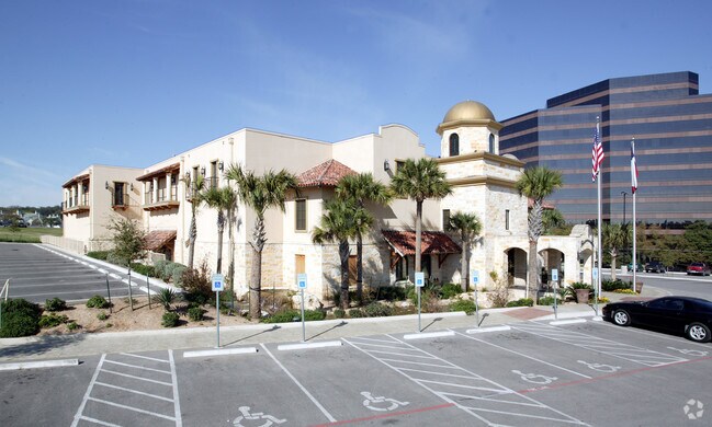
Property Record
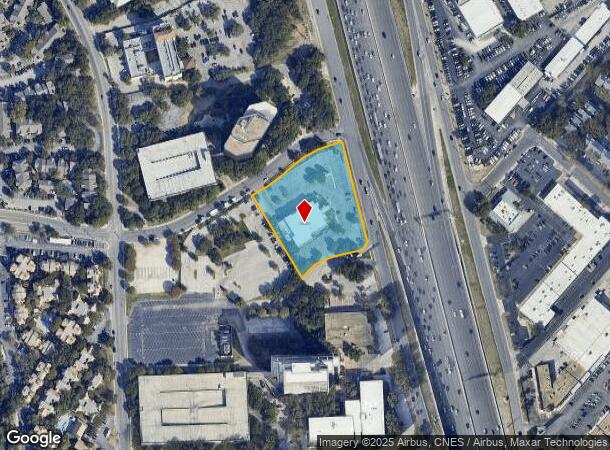
8030 W Interstate 10, San Antonio, TX 78230
NEARBY LISTINGS FOR SALE OR LEASE
Property Detail
8030 W Interstate 10
San Antonio-New Braunfels, TX
Horizon Hill Sub
16928-001-0060
NCB 16928 BLK 1 LOT 6 HORIZON HILL SUBD # 3
Restaurantbuilding
Bexar
X
Texas
48029C0245G
6
2024
2.40 AC
2025
Northwest
181004
San Antonio
15,376 SF
DEMOGRAPHICS near 8030 W Interstate 10
1 Mile
3 Mile
5 Mile
2024 Total Population
22,740
152,760
361,528
2029 Population
24,204
162,869
383,944
Pop Growth 2024-2029
+ 6.44%
+ 6.62%
+ 6.20%
Average Age
35
37
38
2024 Total Households
10,532
68,161
153,064
HH Growth 2024-2029
+ 6.61%
+ 6.91%
+ 6.48%
Median Household Inc
$43,217
$48,268
$52,057
Avg Household Size
2.10
2.20
2.30
2024 Avg HH Vehicles
1.00
1.00
2.00
Median Home Value
$241,467
$211,787
$214,200
Median Year Built
1980
1980
1979
Nearby Places
Map Layers
Map Styles
 Street
 Aerial
- Restaurants
- Banks
- Shops
- Fitness
- Groceries
PUBLIC TRANSPORTATION
COMMUTER RAIL
DRIVE
WALK
Distance
15 min
9.7 mi
AIRPORT
San Antonio International
DRIVE
WALK
Distance
San Antonio International
10 min
6.2 mi
Nearby Properties
Address
Land Use
TOTAL SIZE
Lot Size
Zoning
Address
Land Use
TOTAL SIZE
Lot Size
Zoning
1,414,945 SF
16.77 AC
Address
Land Use
TOTAL SIZE
Lot Size
Zoning
4,465,972 SF
231.60 AC
Address
Land Use
TOTAL SIZE
Lot Size
Zoning
609,267 SF
30.47 AC
Address
Land Use
TOTAL SIZE
Lot Size
Zoning
227,586 SF
25.46 AC
Address
Land Use
TOTAL SIZE
Lot Size
Zoning
429,561 SF
25.70 AC
Address
Land Use
TOTAL SIZE
Lot Size
Zoning
331,715 SF
9.04 AC
Address
Land Use
TOTAL SIZE
Lot Size
Zoning
97.47 AC
Address
Land Use
TOTAL SIZE
Lot Size
Zoning
724,148 SF
18.70 AC
Address
Land Use
TOTAL SIZE
Lot Size
Zoning
278,352 SF
10 AC
Address
Land Use
TOTAL SIZE
Lot Size
Zoning
306,959 SF
15.24 AC
Address
Land Use
TOTAL SIZE
Lot Size
Zoning
482,412 SF
22.97 AC
Address
Land Use
TOTAL SIZE
Lot Size
Zoning
559,808 SF
24.43 AC
Address
Land Use
TOTAL SIZE
Lot Size
Zoning
152,266 SF
18.72 AC
Address
Land Use
TOTAL SIZE
Lot Size
Zoning
183,249 SF
21.94 AC
Address
Land Use
TOTAL SIZE
Lot Size
Zoning
301,817 SF
12.22 AC
Address
Land Use
TOTAL SIZE
Lot Size
Zoning
227,744 SF
3.99 AC
Address
Land Use
TOTAL SIZE
Lot Size
Zoning
223,288 SF
17.01 AC
Address
Land Use
TOTAL SIZE
Lot Size
Zoning
283,165 SF
12.19 AC
Address
Land Use
TOTAL SIZE
Lot Size
Zoning
239,623 SF
26.63 AC
Address
Land Use
TOTAL SIZE
Lot Size
Zoning
506,058 SF
25.23 AC
Address
Land Use
TOTAL SIZE
Lot Size
Zoning
201,339 SF
9.32 AC
Address
Land Use
TOTAL SIZE
Lot Size
Zoning
152,676 SF
13.74 AC
Address
Land Use
TOTAL SIZE
Lot Size
Zoning
288,719 SF
14.66 AC
Address
Land Use
TOTAL SIZE
Lot Size
Zoning
495,484 SF
5.81 AC
Address
Land Use
TOTAL SIZE
Lot Size
Zoning
61.64 AC
Address
Land Use
TOTAL SIZE
Lot Size
Zoning
250,174 SF
14.26 AC
Address
Land Use
TOTAL SIZE
Lot Size
Zoning
54,769 SF
18.94 AC
Address
Land Use
TOTAL SIZE
Lot Size
Zoning
305,379 SF
12.04 AC
Address
Land Use
TOTAL SIZE
Lot Size
Zoning
259,934 SF
9.81 AC
Address
Land Use
TOTAL SIZE
Lot Size
Zoning
402,327 SF
16.65 AC
The World's #1 Commercial Real Estate Marketplace
Connect with us
© 2025 CoStar Group
The information above has been obtained from sources believed reliable. While we do not doubt its accuracy we have not verified it and make no guarantee, warranty or representation about it. It is your responsibility to independently confirm its accuracy and completeness. Any projections, opinions, assumptions, or estimates used are for example only and do not represent the current or future performance of the property. The value of this transaction to you depends on tax and other factors which should be evaluated by your tax, financial, and legal advisors. You and your advisors should conduct a careful, independent investigation of the property to determine to your satisfaction the suitability of the property for your needs.