Property Record
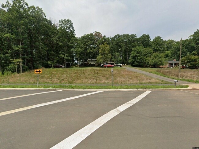
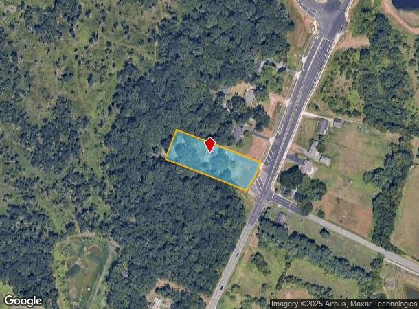
8032 Devlin Rd, Bristow, VA 20136
This Property Is For Sale
Property Detail
8032 Devlin Rd
Washington-Arlington-Alexandria, DC-VA-MD-WV
PCL 1B
7496-87-8145
Prince William
Sfr
Virginia
2024
8746
2025
1.32 AC
901421
Route 29/I-66 Corridor
1,104 SF
Washington, DC
NEARBY LISTINGS FOR SALE OR LEASE
DEMOGRAPHICS near 8032 Devlin Rd
1 mile
3 mile
5 mile
2024 Total Population
3,697
64,283
136,034
2029 Population
3,751
65,761
139,044
Pop Growth 2024-2029
+ 1.46%
+ 2.30%
+ 2.21%
Average Age
35
36
37
2024 Total Households
961
20,684
43,200
HH Growth 2024-2029
+ 1.35%
+ 2.42%
+ 2.28%
Median Household Inc
$209,344
$126,656
$122,266
Avg Household Size
3.60
3.00
3.10
2024 Avg HH Vehicles
2.00
2.00
2.00
Median Home Value
$632,679
$497,005
$489,193
Median Year Built
2004
2001
1999
Nearby Places
Map Layers
Map Styles
 Street
 Aerial
Transit
 Traffic
 Biking
Places
Listings with unknown addresses are not visible on the map
- Restaurants
- Banks
- Shops
- Fitness
- Groceries
PUBLIC TRANSPORTATION
COMMUTER RAIL
Lead (Manassas Line - Virginia Railway Express)
Drive
Walk
Distance
Lead (Manassas Line - Virginia Railway Express)
12 min
6.2 mi
Manassas Amtrak Station (Cardinal - Amtrak, Crescent - Amtrak, Manassas Line - Amtrak, Northeast Regional - Amtrak)
Drive
Walk
Distance
Manassas Amtrak Station (Cardinal - Amtrak, Crescent - Amtrak, Manassas Line - Amtrak, Northeast Regional - Amtrak)
13 min
6.5 mi
AIRPORT
Washington Dulles International
Drive
Walk
Distance
Washington Dulles International
33 min
20.6 mi
Ronald Reagan Washington Ntl
Drive
Walk
Distance
Ronald Reagan Washington Ntl
47 min
35.2 mi
Freight Ports
Port of Baltimore
Drive
Walk
Distance
Port of Baltimore
92 min
71.0 mi
Nearby Properties
Address
Land Use
TOTAL SIZE
Lot Size
Zoning
Address
Land Use
TOTAL SIZE
Lot Size
Zoning
866,820 SF
253.92 AC
M2
Address
Land Use
TOTAL SIZE
Lot Size
Zoning
482,223 SF
28.10 AC
PBD
Address
Land Use
TOTAL SIZE
Lot Size
Zoning
389,649 SF
11.82 AC
M2
Address
Land Use
TOTAL SIZE
Lot Size
Zoning
224,652 SF
12.05 AC
PBD
Address
Land Use
TOTAL SIZE
Lot Size
Zoning
241,249 SF
12.58 AC
PBD
Address
Land Use
TOTAL SIZE
Lot Size
Zoning
325,918 SF
41.38 AC
M2
Address
Land Use
TOTAL SIZE
Lot Size
Zoning
281,000 SF
10.08 AC
PBD
Address
Land Use
TOTAL SIZE
Lot Size
Zoning
259,200 SF
14.22 AC
PBD
Address
Land Use
TOTAL SIZE
Lot Size
Zoning
181.29 AC
M1
Address
Land Use
TOTAL SIZE
Lot Size
Zoning
230,706 SF
13.94 AC
PMD
Address
Land Use
TOTAL SIZE
Lot Size
Zoning
117.22 AC
M1
Address
Land Use
TOTAL SIZE
Lot Size
Zoning
719,742 SF
62.13 AC
M2
Address
Land Use
TOTAL SIZE
Lot Size
Zoning
115,600 SF
10.06 AC
M1
Address
Land Use
TOTAL SIZE
Lot Size
Zoning
123,534 SF
7.85 AC
M1
Address
Land Use
TOTAL SIZE
Lot Size
Zoning
824,085 SF
120.07 AC
MIXED
Address
Land Use
TOTAL SIZE
Lot Size
Zoning
112.48 AC
M2
Address
Land Use
TOTAL SIZE
Lot Size
Zoning
247,608 SF
19.50 AC
PBD
Address
Land Use
TOTAL SIZE
Lot Size
Zoning
312,931 SF
83 AC
M2
Address
Land Use
TOTAL SIZE
Lot Size
Zoning
127,700 SF
7.92 AC
M1
Address
Land Use
TOTAL SIZE
Lot Size
Zoning
409,252 SF
18.75 AC
M2
Address
Land Use
TOTAL SIZE
Lot Size
Zoning
258,716 SF
58.54 AC
M1
Address
Land Use
TOTAL SIZE
Lot Size
Zoning
165,230 SF
12 AC
M2
Address
Land Use
TOTAL SIZE
Lot Size
Zoning
350,906 SF
83.51 AC
M1
Address
Land Use
TOTAL SIZE
Lot Size
Zoning
67.20 AC
M2
Address
Land Use
TOTAL SIZE
Lot Size
Zoning
227,465 SF
31.91 AC
M1
Address
Land Use
TOTAL SIZE
Lot Size
Zoning
311,198 SF
23.50 AC
M2
Address
Land Use
TOTAL SIZE
Lot Size
Zoning
58.30 AC
M1
Address
Land Use
TOTAL SIZE
Lot Size
Zoning
40.47 AC
PBD
Address
Land Use
TOTAL SIZE
Lot Size
Zoning
52.69 AC
M2
Address
Land Use
TOTAL SIZE
Lot Size
Zoning
482,200 SF
29.18 AC
PBD
The World's #1 Commercial Real Estate Marketplace
Connect with us
© 2026 CoStar Group
The information above has been obtained from sources believed reliable. While we do not doubt its accuracy we have not verified it and make no guarantee, warranty or representation about it. It is your responsibility to independently confirm its accuracy and completeness. Any projections, opinions, assumptions, or estimates used are for example only and do not represent the current or future performance of the property. The value of this transaction to you depends on tax and other factors which should be evaluated by your tax, financial, and legal advisors. You and your advisors should conduct a careful, independent investigation of the property to determine to your satisfaction the suitability of the property for your needs.