Property Record
8049 Us Highway 41, Caledonia, WI 53108
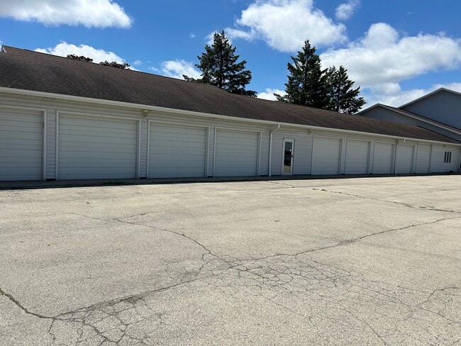
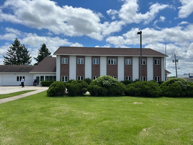
This Property Is For Sale
Current Lease Availabilities
NEARBY LISTINGS FOR SALE OR LEASE
Property Detail
8049 Us Highway 41
Racine-Mount Pleasant, WI
M J Zalewski & Companys 06
104-042206064000
M J ZALEWSKI & CO'S SUB NO 6 COM AT PT 76 S & 20 E OF NW COR OF N146 OF LOT D E555' SLY69' WLY555' N69' TO POB & PT LOT D BEG
Commercialnec
Racine
X
Wisconsin
55101C0079D
c,d
2024
2.39 AC
2024
Racine East
001601
Milwaukee/Madison
DEMOGRAPHICS near 8049 Us Highway 41
1 Mile
3 Mile
5 Mile
2024 Total Population
371
6,443
37,039
2029 Population
363
6,281
36,157
Pop Growth 2024-2029
(2.16%)
(2.51%)
(2.38%)
Average Age
46
43
41
2024 Total Households
152
2,428
14,066
HH Growth 2024-2029
(2.63%)
(2.59%)
(2.49%)
Median Household Inc
$110,937
$106,153
$95,351
Avg Household Size
2.40
2.60
2.50
2024 Avg HH Vehicles
3.00
3.00
2.00
Median Home Value
$345,348
$303,387
$314,752
Median Year Built
1968
1990
1991
Nearby Places
Map Layers
Map Styles
 Street
 Aerial
- Restaurants
- Banks
- Shops
- Fitness
- Groceries
PUBLIC TRANSPORTATION
COMMUTER RAIL
General Mitchell Intl. Airport Amtrak Station (Hiawatha Service - Amtrak)
DRIVE
WALK
Distance
General Mitchell Intl. Airport Amtrak Station (Hiawatha Service - Amtrak)
14 min
9.3 mi
AIRPORT
General Mitchell International
DRIVE
WALK
Distance
General Mitchell International
14 min
10.2 mi
Freight Ports
Port Milwaukee
DRIVE
WALK
Distance
Port Milwaukee
19 min
14.1 mi
Nearby Properties
Address
Land Use
TOTAL SIZE
Lot Size
Zoning
Address
Land Use
TOTAL SIZE
Lot Size
Zoning
75.05 AC
Address
Land Use
TOTAL SIZE
Lot Size
Zoning
23.29 AC
Address
Land Use
TOTAL SIZE
Lot Size
Zoning
64,800 SF
28.17 AC
Address
Land Use
TOTAL SIZE
Lot Size
Zoning
48.65 AC
Address
Land Use
TOTAL SIZE
Lot Size
Zoning
17.37 AC
Address
Land Use
TOTAL SIZE
Lot Size
Zoning
28.04 AC
Address
Land Use
TOTAL SIZE
Lot Size
Zoning
19.25 AC
Address
Land Use
TOTAL SIZE
Lot Size
Zoning
26.03 AC
Address
Land Use
TOTAL SIZE
Lot Size
Zoning
42,253 SF
6.93 AC
Address
Land Use
TOTAL SIZE
Lot Size
Zoning
57,474 SF
5.07 AC
Address
Land Use
TOTAL SIZE
Lot Size
Zoning
21.21 AC
Address
Land Use
TOTAL SIZE
Lot Size
Zoning
12.45 AC
Address
Land Use
TOTAL SIZE
Lot Size
Zoning
Address
Land Use
TOTAL SIZE
Lot Size
Zoning
16.25 AC
Address
Land Use
TOTAL SIZE
Lot Size
Zoning
Address
Land Use
TOTAL SIZE
Lot Size
Zoning
12.31 AC
Address
Land Use
TOTAL SIZE
Lot Size
Zoning
Address
Land Use
TOTAL SIZE
Lot Size
Zoning
13.16 AC
Address
Land Use
TOTAL SIZE
Lot Size
Zoning
Address
Land Use
TOTAL SIZE
Lot Size
Zoning
13.05 AC
Address
Land Use
TOTAL SIZE
Lot Size
Zoning
95.21 AC
Address
Land Use
TOTAL SIZE
Lot Size
Zoning
411,369 SF
53.72 AC
Address
Land Use
TOTAL SIZE
Lot Size
Zoning
10.75 AC
Address
Land Use
TOTAL SIZE
Lot Size
Zoning
129,024 SF
7.61 AC
Address
Land Use
TOTAL SIZE
Lot Size
Zoning
Address
Land Use
TOTAL SIZE
Lot Size
Zoning
34.39 AC
Address
Land Use
TOTAL SIZE
Lot Size
Zoning
24.91 AC
Address
Land Use
TOTAL SIZE
Lot Size
Zoning
8.74 AC
Address
Land Use
TOTAL SIZE
Lot Size
Zoning
Address
Land Use
TOTAL SIZE
Lot Size
Zoning
The World's #1 Commercial Real Estate Marketplace
Connect with us
© 2026 CoStar Group
The information above has been obtained from sources believed reliable. While we do not doubt its accuracy we have not verified it and make no guarantee, warranty or representation about it. It is your responsibility to independently confirm its accuracy and completeness. Any projections, opinions, assumptions, or estimates used are for example only and do not represent the current or future performance of the property. The value of this transaction to you depends on tax and other factors which should be evaluated by your tax, financial, and legal advisors. You and your advisors should conduct a careful, independent investigation of the property to determine to your satisfaction the suitability of the property for your needs.