Property Record
8033 Walnut Rd, Clinton, IL 61727
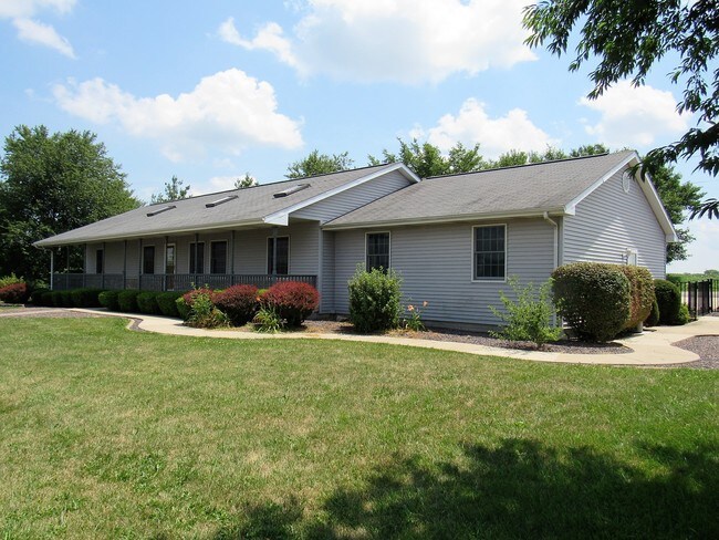


Property Detail
8033 Walnut Rd
07-22-300-003
T20N R2E
Commercialnec
Dewitt
A Areas with a 1% annual chance of flooding and a 26% chance of flooding over the life of a 30-year mortgage.
Illinois
2024
2.17 AC
2024
Illinois North Area
971600
Other Market Areas
1,800 SF
NEARBY LISTINGS FOR SALE OR LEASE
DEMOGRAPHICS near 8033 Walnut Rd
1 mile
3 mile
5 mile
2025 Total Population
1,076
7,912
9,225
2030 Population
1,071
7,894
9,181
Pop Growth 2025-2030
(0.46%)
(0.23%)
(0.48%)
Average Age
41
41
42
2025 Total Households
449
3,445
3,994
HH Growth 2025-2030
(0.67%)
(0.23%)
(0.48%)
Median Household Inc
$64,207
$60,226
$62,465
Avg Household Size
2.40
2.20
2.20
2025 Avg HH Vehicles
2.00
2.00
2.00
Median Home Value
$127,055
$115,625
$129,406
Median Year Built
1954
1957
1959
Nearby Places
Map Layers
Map Styles
 Street
 Aerial
Transit
 Traffic
 Biking
Places
Listings with unknown addresses are not visible on the map
- Restaurants
- Banks
- Shops
- Fitness
- Groceries
PUBLIC TRANSPORTATION
AIRPORT
Central Il Regional/Bloomington-Normal
Drive
Walk
Distance
Central Il Regional/Bloomington-Normal
41 min
26.9 mi
SALE & LEASE HISTORY
LISTING DATE
SALE/LEASE

Aug 25, 2017
For Sale
Nearby Properties
Address
Land Use
TOTAL SIZE
Lot Size
Zoning
Address
Land Use
TOTAL SIZE
Lot Size
Zoning
59.49 AC
Address
Land Use
TOTAL SIZE
Lot Size
Zoning
7.40 AC
Address
Land Use
TOTAL SIZE
Lot Size
Zoning
Address
Land Use
TOTAL SIZE
Lot Size
Zoning
Address
Land Use
TOTAL SIZE
Lot Size
Zoning
23,034 SF
5.46 AC
Address
Land Use
TOTAL SIZE
Lot Size
Zoning
14,400 SF
5.83 AC
Address
Land Use
TOTAL SIZE
Lot Size
Zoning
16.80 AC
Address
Land Use
TOTAL SIZE
Lot Size
Zoning
8,896 SF
1.54 AC
Address
Land Use
TOTAL SIZE
Lot Size
Zoning
19.04 AC
Address
Land Use
TOTAL SIZE
Lot Size
Zoning
42,750 SF
14.57 AC
Address
Land Use
TOTAL SIZE
Lot Size
Zoning
653,182 SF
34.16 AC
Address
Land Use
TOTAL SIZE
Lot Size
Zoning
34,875 SF
4.33 AC
Address
Land Use
TOTAL SIZE
Lot Size
Zoning
10,077 SF
1.73 AC
Address
Land Use
TOTAL SIZE
Lot Size
Zoning
Address
Land Use
TOTAL SIZE
Lot Size
Zoning
28,800 SF
6.18 AC
Address
Land Use
TOTAL SIZE
Lot Size
Zoning
4,184 SF
1.41 AC
Address
Land Use
TOTAL SIZE
Lot Size
Zoning
6.29 AC
Address
Land Use
TOTAL SIZE
Lot Size
Zoning
27,690 SF
2.37 AC
Address
Land Use
TOTAL SIZE
Lot Size
Zoning
18,876 SF
0.81 AC
Address
Land Use
TOTAL SIZE
Lot Size
Zoning
1.44 AC
Address
Land Use
TOTAL SIZE
Lot Size
Zoning
0.56 AC
Address
Land Use
TOTAL SIZE
Lot Size
Zoning
1.21 AC
Address
Land Use
TOTAL SIZE
Lot Size
Zoning
0.73 AC
Address
Land Use
TOTAL SIZE
Lot Size
Zoning
1.38 AC
Address
Land Use
TOTAL SIZE
Lot Size
Zoning
Address
Land Use
TOTAL SIZE
Lot Size
Zoning
1.64 AC
Address
Land Use
TOTAL SIZE
Lot Size
Zoning
0.62 AC
Address
Land Use
TOTAL SIZE
Lot Size
Zoning
0.60 AC
Address
Land Use
TOTAL SIZE
Lot Size
Zoning
20,825 SF
4.71 AC
Address
Land Use
TOTAL SIZE
Lot Size
Zoning
61,900 SF
1.65 AC
The World's #1 Commercial Real Estate Marketplace
Connect with us
© 2026 CoStar Group
The information above has been obtained from sources believed reliable. While we do not doubt its accuracy we have not verified it and make no guarantee, warranty or representation about it. It is your responsibility to independently confirm its accuracy and completeness. Any projections, opinions, assumptions, or estimates used are for example only and do not represent the current or future performance of the property. The value of this transaction to you depends on tax and other factors which should be evaluated by your tax, financial, and legal advisors. You and your advisors should conduct a careful, independent investigation of the property to determine to your satisfaction the suitability of the property for your needs.