Property Record
8035 Mariners Dr, Stockton, CA 95219
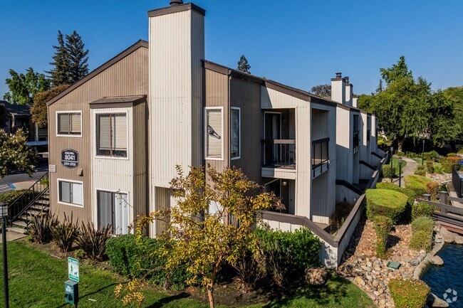

Property Detail
8035 Mariners Dr
Stockton-Lodi, CA
87 FM 12 & PT TO 15 SPLIT 86086601
071-260-14
San Joaquin
Apartment
California
AE The base floodplain where base flood elevations are provided. AE Zones are now used on new format FIRMs instead of A1-A30 Zones.
102
2025
10.16 AC
2025
Outer Lakeview
003215
Stockton/Modesto
161,229 SF
NEARBY LISTINGS FOR SALE OR LEASE
DEMOGRAPHICS near 8035 Mariners Dr
1 mile
3 mile
5 mile
2025 Total Population
17,900
111,241
220,852
2030 Population
18,551
115,921
229,969
Pop Growth 2025-2030
+ 3.64%
+ 4.21%
+ 4.13%
Average Age
38
39
38
2025 Total Households
5,928
37,443
72,707
HH Growth 2025-2030
+ 3.90%
+ 4.24%
+ 4.26%
Median Household Inc
$80,895
$92,051
$83,060
Avg Household Size
2.80
2.90
2.90
2025 Avg HH Vehicles
2.00
2.00
2.00
Median Home Value
$446,025
$483,509
$450,692
Median Year Built
1980
1981
1978
Nearby Places
Map Layers
Map Styles
 Street
 Aerial
Layers
 Traffic
 Biking
Places
Listings with unknown addresses are not visible on the map
- Restaurants
- Banks
- Shops
- Fitness
- Groceries
PUBLIC TRANSPORTATION
COMMUTER RAIL
Stockton (San Joaquins - Amtrak)
Drive
Walk
Distance
Stockton (San Joaquins - Amtrak)
12 min
8.0 mi
Stockton- Robert J Cabral Station (ACE Train - Altamont Corridor Express)
Drive
Walk
Distance
Stockton- Robert J Cabral Station (ACE Train - Altamont Corridor Express)
13 min
8.6 mi
AIRPORT
Stockton Metro
Drive
Walk
Distance
Stockton Metro
19 min
13.4 mi
Freight Ports
Port of Stockton
Drive
Walk
Distance
Port of Stockton
9 min
5.8 mi
Nearby Properties
Address
Land Use
TOTAL SIZE
Lot Size
Zoning
Address
Land Use
TOTAL SIZE
Lot Size
Zoning
10,334 SF
22.41 AC
Address
Land Use
TOTAL SIZE
Lot Size
Zoning
60,137 SF
7.22 AC
Address
Land Use
TOTAL SIZE
Lot Size
Zoning
9,192 SF
6.63 AC
Address
Land Use
TOTAL SIZE
Lot Size
Zoning
324,208 SF
16.45 AC
Address
Land Use
TOTAL SIZE
Lot Size
Zoning
254,378 SF
17.07 AC
Address
Land Use
TOTAL SIZE
Lot Size
Zoning
27,000 SF
17.43 AC
Address
Land Use
TOTAL SIZE
Lot Size
Zoning
236,618 SF
22.37 AC
Address
Land Use
TOTAL SIZE
Lot Size
Zoning
151,271 SF
8.97 AC
Address
Land Use
TOTAL SIZE
Lot Size
Zoning
18.66 AC
Address
Land Use
TOTAL SIZE
Lot Size
Zoning
89,725 SF
4.02 AC
Address
Land Use
TOTAL SIZE
Lot Size
Zoning
Address
Land Use
TOTAL SIZE
Lot Size
Zoning
123,800 SF
10.73 AC
Address
Land Use
TOTAL SIZE
Lot Size
Zoning
2.62 AC
Address
Land Use
TOTAL SIZE
Lot Size
Zoning
76,700 SF
3.81 AC
Address
Land Use
TOTAL SIZE
Lot Size
Zoning
28,168 SF
6.61 AC
MX
Address
Land Use
TOTAL SIZE
Lot Size
Zoning
77,568 SF
2.58 AC
Address
Land Use
TOTAL SIZE
Lot Size
Zoning
81,482 SF
5 AC
RM
Address
Land Use
TOTAL SIZE
Lot Size
Zoning
5,888 SF
3.64 AC
Address
Land Use
TOTAL SIZE
Lot Size
Zoning
138,136 SF
13.60 AC
Address
Land Use
TOTAL SIZE
Lot Size
Zoning
176,492 SF
10.55 AC
Address
Land Use
TOTAL SIZE
Lot Size
Zoning
146,660 SF
8.35 AC
Address
Land Use
TOTAL SIZE
Lot Size
Zoning
5.70 AC
RL
Address
Land Use
TOTAL SIZE
Lot Size
Zoning
44,752 SF
2.31 AC
Address
Land Use
TOTAL SIZE
Lot Size
Zoning
11,720 SF
4.28 AC
Address
Land Use
TOTAL SIZE
Lot Size
Zoning
64,656 SF
3.55 AC
Address
Land Use
TOTAL SIZE
Lot Size
Zoning
46,982 SF
2.26 AC
Address
Land Use
TOTAL SIZE
Lot Size
Zoning
8,000 SF
7.34 AC
Address
Land Use
TOTAL SIZE
Lot Size
Zoning
60,840 SF
10 AC
CC
Address
Land Use
TOTAL SIZE
Lot Size
Zoning
11,603 SF
5.76 AC
The World's #1 Commercial Real Estate Marketplace
Connect with us
© 2026 CoStar Group
The information above has been obtained from sources believed reliable. While we do not doubt its accuracy we have not verified it and make no guarantee, warranty or representation about it. It is your responsibility to independently confirm its accuracy and completeness. Any projections, opinions, assumptions, or estimates used are for example only and do not represent the current or future performance of the property. The value of this transaction to you depends on tax and other factors which should be evaluated by your tax, financial, and legal advisors. You and your advisors should conduct a careful, independent investigation of the property to determine to your satisfaction the suitability of the property for your needs.