Property Record
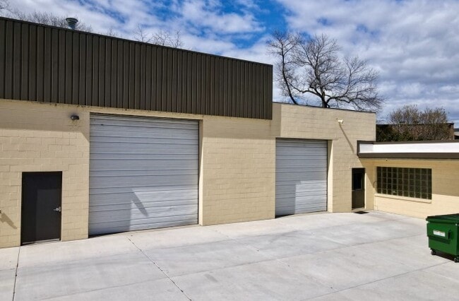
8035 N Port Washington Rd, Milwaukee, WI 53217


Current Lease Availabilities
NEARBY LISTINGS FOR SALE OR LEASE
Property Detail
8035 N Port Washington Rd
060-9983-000
COM 1896.17 FT. W. & 204.50 FT. N. OF SE COR OF SE1/4 SEC. 8-8-22 N. 140 FT. E. 271.26 FT. SWLY ALG CEN OF RD. 140.28 FT. TH W. 262.90 FT. TO BEG. ALSO E. 10 FT. OF FOLLOWING DESC. PREMISES; COM. 2141.17 FT. W. & 214.50 FT. N. OF SE COR. OF SE1/4 SEC
Commercialnec
Milwaukee
X
Wisconsin
55089C0270G
0.89 AC
2024
North Shore
2024
Milwaukee/Madison
035200
Milwaukee-Waukesha-West Allis, WI
DEMOGRAPHICS near 8035 N Port Washington Rd
1 Mile
3 Mile
5 Mile
2024 Total Population
5,502
34,441
123,482
2029 Population
5,371
33,783
121,671
Pop Growth 2024-2029
(2.38%)
(1.91%)
(1.47%)
Average Age
43
43
40
2024 Total Households
2,354
14,193
50,047
HH Growth 2024-2029
(2.42%)
(1.97%)
(1.57%)
Median Household Inc
$123,028
$101,408
$65,792
Avg Household Size
2.30
2.40
2.40
2024 Avg HH Vehicles
2.00
2.00
2.00
Median Home Value
$351,878
$343,404
$273,024
Median Year Built
1958
1961
1958
Nearby Places
Map Layers
Map Styles
 Street
 Aerial
- Restaurants
- Banks
- Shops
- Fitness
- Groceries
PUBLIC TRANSPORTATION
COMMUTER RAIL
Milwaukee (Empire Builder - Amtrak)
DRIVE
WALK
Distance
Milwaukee (Empire Builder - Amtrak)
17 min
9.7 mi
AIRPORT
General Mitchell International
DRIVE
WALK
Distance
General Mitchell International
27 min
16.3 mi
Freight Ports
Port Milwaukee
DRIVE
WALK
Distance
Port Milwaukee
20 min
12.1 mi
Nearby Properties
Address
Land Use
TOTAL SIZE
Lot Size
Zoning
Address
Land Use
TOTAL SIZE
Lot Size
Zoning
305,573 SF
3.20 AC
Address
Land Use
TOTAL SIZE
Lot Size
Zoning
527,776 SF
33.23 AC
Address
Land Use
TOTAL SIZE
Lot Size
Zoning
19.64 AC
Address
Land Use
TOTAL SIZE
Lot Size
Zoning
Address
Land Use
TOTAL SIZE
Lot Size
Zoning
Address
Land Use
TOTAL SIZE
Lot Size
Zoning
145,218 SF
10.23 AC
Address
Land Use
TOTAL SIZE
Lot Size
Zoning
72,824 SF
11.57 AC
Address
Land Use
TOTAL SIZE
Lot Size
Zoning
Address
Land Use
TOTAL SIZE
Lot Size
Zoning
Address
Land Use
TOTAL SIZE
Lot Size
Zoning
235,364 SF
7.20 AC
Address
Land Use
TOTAL SIZE
Lot Size
Zoning
90,714 SF
4.18 AC
Address
Land Use
TOTAL SIZE
Lot Size
Zoning
4.26 AC
Address
Land Use
TOTAL SIZE
Lot Size
Zoning
74,526 SF
5.42 AC
Address
Land Use
TOTAL SIZE
Lot Size
Zoning
48,540 SF
4.28 AC
Address
Land Use
TOTAL SIZE
Lot Size
Zoning
127,584 SF
3.28 AC
Address
Land Use
TOTAL SIZE
Lot Size
Zoning
Address
Land Use
TOTAL SIZE
Lot Size
Zoning
81,300 SF
0.71 AC
Address
Land Use
TOTAL SIZE
Lot Size
Zoning
Address
Land Use
TOTAL SIZE
Lot Size
Zoning
128,512 SF
3.57 AC
Address
Land Use
TOTAL SIZE
Lot Size
Zoning
13.08 AC
Address
Land Use
TOTAL SIZE
Lot Size
Zoning
34,949 SF
6.01 AC
Address
Land Use
TOTAL SIZE
Lot Size
Zoning
Address
Land Use
TOTAL SIZE
Lot Size
Zoning
56,706 SF
4.53 AC
Address
Land Use
TOTAL SIZE
Lot Size
Zoning
7.84 AC
Address
Land Use
TOTAL SIZE
Lot Size
Zoning
87,286 SF
6.02 AC
Address
Land Use
TOTAL SIZE
Lot Size
Zoning
97,330 SF
3.18 AC
Address
Land Use
TOTAL SIZE
Lot Size
Zoning
21.20 AC
Address
Land Use
TOTAL SIZE
Lot Size
Zoning
62,080 SF
7.47 AC
Address
Land Use
TOTAL SIZE
Lot Size
Zoning
26.71 AC
Address
Land Use
TOTAL SIZE
Lot Size
Zoning
54,000 SF
2.28 AC
The World's #1 Commercial Real Estate Marketplace
Connect with us
© 2025 CoStar Group
The information above has been obtained from sources believed reliable. While we do not doubt its accuracy we have not verified it and make no guarantee, warranty or representation about it. It is your responsibility to independently confirm its accuracy and completeness. Any projections, opinions, assumptions, or estimates used are for example only and do not represent the current or future performance of the property. The value of this transaction to you depends on tax and other factors which should be evaluated by your tax, financial, and legal advisors. You and your advisors should conduct a careful, independent investigation of the property to determine to your satisfaction the suitability of the property for your needs.