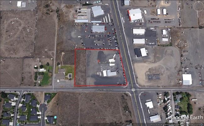
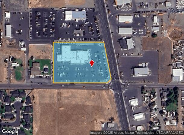
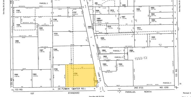
Property Record
80364 N Highway 395, Hermiston, OR 97838
NEARBY LISTINGS FOR SALE OR LEASE
Property Detail
80364 N Highway 395
Commercialnec
Umatilla
X
Oregon
41059C0585G
4.20 AC
2024
Oregon East Area
2024
Other Market Areas
951000
Hermiston-Pendleton, OR
30,262 SF
124980
DEMOGRAPHICS near 80364 N Highway 395
1 Mile
3 Mile
5 Mile
2024 Total Population
4,311
25,502
35,354
2029 Population
4,370
25,733
35,625
Pop Growth 2024-2029
+ 1.37%
+ 0.91%
+ 0.77%
Average Age
34
36
37
2024 Total Households
1,336
8,720
11,619
HH Growth 2024-2029
+ 1.35%
+ 0.93%
+ 0.81%
Median Household Inc
$75,403
$64,169
$62,457
Avg Household Size
3.10
2.80
2.90
2024 Avg HH Vehicles
2.00
2.00
2.00
Median Home Value
$242,424
$247,533
$247,180
Median Year Built
2005
1986
1987
Nearby Places
Map Layers
Map Styles
 Street
 Aerial
- Restaurants
- Banks
- Shops
- Fitness
- Groceries
PUBLIC TRANSPORTATION
AIRPORT
Tri-Cities
DRIVE
WALK
Distance
Tri-Cities
44 min
34.3 mi
Freight Ports
Port of Vancouver
DRIVE
WALK
Distance
Port of Vancouver
229 min
194.3 mi
SALE & LEASE HISTORY
LISTING DATE
SALE/LEASE

Nov 10, 2017
For Sale
Aug 29, 2017
For Sale
Nearby Properties
Address
Land Use
TOTAL SIZE
Lot Size
Zoning
Address
Land Use
TOTAL SIZE
Lot Size
Zoning
10 SF
15.99 AC
R2
Address
Land Use
TOTAL SIZE
Lot Size
Zoning
117,280 SF
27.93 AC
R1
Address
Land Use
TOTAL SIZE
Lot Size
Zoning
78,854 SF
13.38 AC
R-1
Address
Land Use
TOTAL SIZE
Lot Size
Zoning
61,423 SF
14.82 AC
R2
Address
Land Use
TOTAL SIZE
Lot Size
Zoning
55,588 SF
14.26 AC
R-1
Address
Land Use
TOTAL SIZE
Lot Size
Zoning
37,804 SF
6.79 AC
C-2
Address
Land Use
TOTAL SIZE
Lot Size
Zoning
162,537 SF
12.83 AC
C-1
Address
Land Use
TOTAL SIZE
Lot Size
Zoning
20 SF
178.20 AC
M-1
Address
Land Use
TOTAL SIZE
Lot Size
Zoning
101,854 SF
10.23 AC
M-1
Address
Land Use
TOTAL SIZE
Lot Size
Zoning
71,616 SF
8.33 AC
LI
Address
Land Use
TOTAL SIZE
Lot Size
Zoning
53,826 SF
1.61 AC
C-2
Address
Land Use
TOTAL SIZE
Lot Size
Zoning
10 SF
5.59 AC
C-2
Address
Land Use
TOTAL SIZE
Lot Size
Zoning
10 SF
2.25 AC
R2
Address
Land Use
TOTAL SIZE
Lot Size
Zoning
40.32 AC
M-1
Address
Land Use
TOTAL SIZE
Lot Size
Zoning
75,359 SF
3.30 AC
R3
Address
Land Use
TOTAL SIZE
Lot Size
Zoning
25,914 SF
3 AC
C-2
Address
Land Use
TOTAL SIZE
Lot Size
Zoning
36,400 SF
23.96 AC
R1
Address
Land Use
TOTAL SIZE
Lot Size
Zoning
9,000 SF
4.63 AC
R1
Address
Land Use
TOTAL SIZE
Lot Size
Zoning
27,468 SF
4.67 AC
R3
Address
Land Use
TOTAL SIZE
Lot Size
Zoning
86.21 AC
C-2,M-2
Address
Land Use
TOTAL SIZE
Lot Size
Zoning
40,092 SF
4.86 AC
R3
Address
Land Use
TOTAL SIZE
Lot Size
Zoning
10 SF
3.26 AC
PUD, C-2,
Address
Land Use
TOTAL SIZE
Lot Size
Zoning
10 SF
25.79 AC
R1
Address
Land Use
TOTAL SIZE
Lot Size
Zoning
36,184 SF
3.94 AC
R3
Address
Land Use
TOTAL SIZE
Lot Size
Zoning
10 SF
6.94 AC
R1
Address
Land Use
TOTAL SIZE
Lot Size
Zoning
36,726 SF
1.39 AC
C-2
Address
Land Use
TOTAL SIZE
Lot Size
Zoning
10 SF
1.13 AC
C-2
Address
Land Use
TOTAL SIZE
Lot Size
Zoning
25,704 SF
8.07 AC
C-2
Address
Land Use
TOTAL SIZE
Lot Size
Zoning
44,590 SF
5.68 AC
R2
The World's #1 Commercial Real Estate Marketplace
Connect with us
© 2026 CoStar Group
The information above has been obtained from sources believed reliable. While we do not doubt its accuracy we have not verified it and make no guarantee, warranty or representation about it. It is your responsibility to independently confirm its accuracy and completeness. Any projections, opinions, assumptions, or estimates used are for example only and do not represent the current or future performance of the property. The value of this transaction to you depends on tax and other factors which should be evaluated by your tax, financial, and legal advisors. You and your advisors should conduct a careful, independent investigation of the property to determine to your satisfaction the suitability of the property for your needs.