Property Record
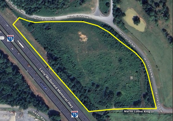
803B E Mitchell Rd Nw, Adairsville, GA 30103
Property Detail
803B E Mitchell Rd Nw
0043-0222-006
LL222 LD 15
Agriculturalland
BARTOW
C1
Georgia
B and X Area of moderate flood hazard, usually the area between the limits of the 100-year and 500-year floods.
5.50 AC
2025
Bartow County
2025
Atlanta
960201
Atlanta-Sandy Springs-Roswell, GA
NEARBY LISTINGS FOR SALE OR LEASE
DEMOGRAPHICS near 803B E Mitchell Rd Nw
1 mile
3 mile
5 mile
2025 Total Population
1,048
8,827
15,599
2030 Population
1,142
9,565
16,804
Pop Growth 2025-2030
+ 8.97%
+ 8.36%
+ 7.72%
Average Age
36
38
39
2025 Total Households
386
3,285
5,738
HH Growth 2025-2030
+ 9.07%
+ 8.40%
+ 7.77%
Median Household Inc
$84,033
$76,630
$76,232
Avg Household Size
2.70
2.70
2.70
2025 Avg HH Vehicles
2.00
2.00
2.00
Median Home Value
$280,840
$252,517
$263,734
Median Year Built
2007
2001
1999
Nearby Places
Map Layers
Map Styles
 Street
 Aerial
Layers
 Traffic
 Biking
Places
Listings with unknown addresses are not visible on the map
- Restaurants
- Banks
- Shops
- Fitness
- Groceries
SALE & LEASE HISTORY
LISTING DATE
SALE/LEASE

Sep 30, 2025
For Sale
Nearby Properties
Address
Land Use
TOTAL SIZE
Lot Size
Zoning
Address
Land Use
TOTAL SIZE
Lot Size
Zoning
3,201.68 AC
IN
Address
Land Use
TOTAL SIZE
Lot Size
Zoning
1,038,487 SF
80.91 AC
I-2
Address
Land Use
TOTAL SIZE
Lot Size
Zoning
926,772 SF
64.21 AC
Address
Land Use
TOTAL SIZE
Lot Size
Zoning
495,040 SF
Address
Land Use
TOTAL SIZE
Lot Size
Zoning
670,659 SF
115.64 AC
IN
Address
Land Use
TOTAL SIZE
Lot Size
Zoning
140,574 SF
88.39 AC
A1
Address
Land Use
TOTAL SIZE
Lot Size
Zoning
430,100 SF
Address
Land Use
TOTAL SIZE
Lot Size
Zoning
769,184 SF
49.82 AC
IN
Address
Land Use
TOTAL SIZE
Lot Size
Zoning
164,201 SF
68.88 AC
Address
Land Use
TOTAL SIZE
Lot Size
Zoning
660 SF
67.19 AC
IN
Address
Land Use
TOTAL SIZE
Lot Size
Zoning
497,640 SF
31.58 AC
Address
Land Use
TOTAL SIZE
Lot Size
Zoning
2.96 AC
Address
Land Use
TOTAL SIZE
Lot Size
Zoning
444,267 SF
70.09 AC
Address
Land Use
TOTAL SIZE
Lot Size
Zoning
304,308 SF
63.15 AC
I-2
Address
Land Use
TOTAL SIZE
Lot Size
Zoning
228,119 SF
19.25 AC
IN
Address
Land Use
TOTAL SIZE
Lot Size
Zoning
554,520 SF
60.95 AC
IN
Address
Land Use
TOTAL SIZE
Lot Size
Zoning
114,989 SF
14.35 AC
IN
Address
Land Use
TOTAL SIZE
Lot Size
Zoning
4.16 AC
IN
Address
Land Use
TOTAL SIZE
Lot Size
Zoning
431.49 AC
IN
Address
Land Use
TOTAL SIZE
Lot Size
Zoning
300,000 SF
17.48 AC
IN
Address
Land Use
TOTAL SIZE
Lot Size
Zoning
205,158 SF
20.63 AC
IN
Address
Land Use
TOTAL SIZE
Lot Size
Zoning
87,428 SF
67.40 AC
Address
Land Use
TOTAL SIZE
Lot Size
Zoning
51,741 SF
7.57 AC
IN
Address
Land Use
TOTAL SIZE
Lot Size
Zoning
11,000 SF
62.16 AC
A1
Address
Land Use
TOTAL SIZE
Lot Size
Zoning
Address
Land Use
TOTAL SIZE
Lot Size
Zoning
99,800 SF
9.16 AC
IN
Address
Land Use
TOTAL SIZE
Lot Size
Zoning
34,300 SF
33.64 AC
IN
Address
Land Use
TOTAL SIZE
Lot Size
Zoning
3,500 SF
27.92 AC
IN
Address
Land Use
TOTAL SIZE
Lot Size
Zoning
89,070 SF
43.20 AC
IN
Address
Land Use
TOTAL SIZE
Lot Size
Zoning
38,760 SF
2.50 AC
The World's #1 Commercial Real Estate Marketplace
Connect with us
© 2026 CoStar Group
The information above has been obtained from sources believed reliable. While we do not doubt its accuracy we have not verified it and make no guarantee, warranty or representation about it. It is your responsibility to independently confirm its accuracy and completeness. Any projections, opinions, assumptions, or estimates used are for example only and do not represent the current or future performance of the property. The value of this transaction to you depends on tax and other factors which should be evaluated by your tax, financial, and legal advisors. You and your advisors should conduct a careful, independent investigation of the property to determine to your satisfaction the suitability of the property for your needs.