Property Record
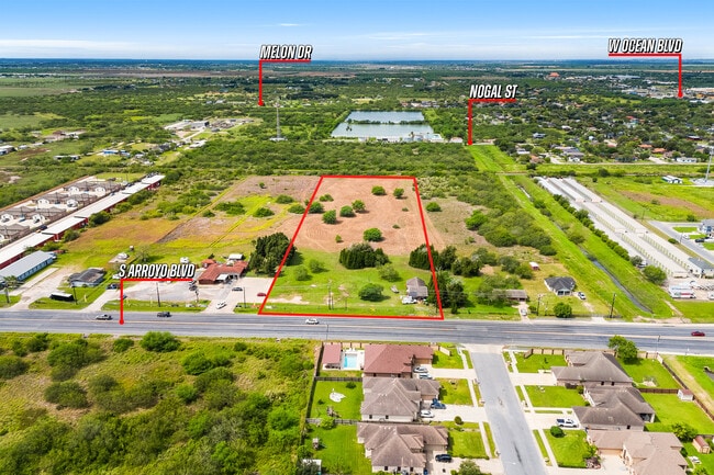
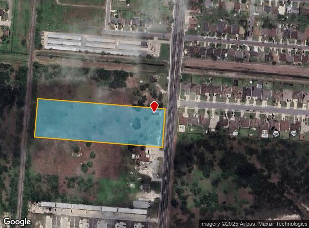
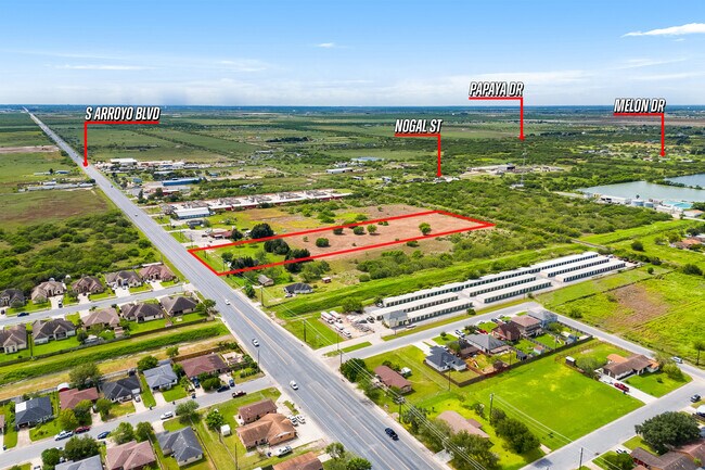
804 S Paredes Line Rd, Los Fresnos, TX 78566
This Property Is For Sale
NEARBY LISTINGS FOR SALE OR LEASE
Property Detail
804 S Paredes Line Rd
Brownsville-Harlingen, TX
Noyola Subdivision
769900-0010-002000
Cameron
Ruralagriculturalresidence
Texas
X
5.56 AC
48061C0475F
Outlying Cameron County
1,404 SF
Brownsville/Harlingen
DEMOGRAPHICS near 804 S Paredes Line Rd
1 Mile
3 Mile
5 Mile
2024 Total Population
6,116
15,001
34,995
2029 Population
6,405
15,665
36,355
Pop Growth 2024-2029
+ 4.73%
+ 4.43%
+ 3.89%
Average Age
35
35
34
2024 Total Households
1,778
4,357
9,752
HH Growth 2024-2029
+ 4.78%
+ 4.57%
+ 4.06%
Median Household Inc
$70,663
$68,787
$74,180
Avg Household Size
3.40
3.40
3.50
2024 Avg HH Vehicles
2.00
2.00
2.00
Median Home Value
$156,437
$168,367
$198,950
Median Year Built
1996
2000
2002
Nearby Places
- Restaurants
- Banks
- Shops
- Fitness
- Groceries
PUBLIC TRANSPORTATION
AIRPORT
Brownsville/South Padre Island International
DRIVE
WALK
Distance
Brownsville/South Padre Island International
20 min
13.6 mi
Valley International
DRIVE
WALK
Distance
Valley International
37 min
21.4 mi
Freight Ports
Port of Brownsville
DRIVE
WALK
Distance
Port of Brownsville
12 min
9.8 mi
Nearby Properties
Address
Land Use
TOTAL SIZE
Lot Size
Zoning
Address
Land Use
TOTAL SIZE
Lot Size
Zoning
230,098 SF
12.01 AC
Address
Land Use
TOTAL SIZE
Lot Size
Zoning
195,304 SF
33.09 AC
C
Address
Land Use
TOTAL SIZE
Lot Size
Zoning
123,695 SF
15.77 AC
Address
Land Use
TOTAL SIZE
Lot Size
Zoning
44,094 SF
2.09 AC
Address
Land Use
TOTAL SIZE
Lot Size
Zoning
113,205 SF
40 AC
C
Address
Land Use
TOTAL SIZE
Lot Size
Zoning
48,657 SF
2.37 AC
Address
Land Use
TOTAL SIZE
Lot Size
Zoning
84,577 SF
15.05 AC
Address
Land Use
TOTAL SIZE
Lot Size
Zoning
12,049 SF
2.06 AC
Address
Land Use
TOTAL SIZE
Lot Size
Zoning
33,052 SF
3.01 AC
Address
Land Use
TOTAL SIZE
Lot Size
Zoning
25,984 SF
1.17 AC
Address
Land Use
TOTAL SIZE
Lot Size
Zoning
8,477 SF
0.57 AC
Address
Land Use
TOTAL SIZE
Lot Size
Zoning
17,730 SF
0.65 AC
Address
Land Use
TOTAL SIZE
Lot Size
Zoning
29,688 SF
7.27 AC
Address
Land Use
TOTAL SIZE
Lot Size
Zoning
35,290 SF
9.06 AC
Address
Land Use
TOTAL SIZE
Lot Size
Zoning
21,656 SF
1.15 AC
Address
Land Use
TOTAL SIZE
Lot Size
Zoning
6,430 SF
1.66 AC
Address
Land Use
TOTAL SIZE
Lot Size
Zoning
27,148 SF
3.50 AC
A-C
Address
Land Use
TOTAL SIZE
Lot Size
Zoning
20,521 SF
4.58 AC
Address
Land Use
TOTAL SIZE
Lot Size
Zoning
38.50 AC
C
Address
Land Use
TOTAL SIZE
Lot Size
Zoning
17,312 SF
1.15 AC
Address
Land Use
TOTAL SIZE
Lot Size
Zoning
4,828 SF
0.92 AC
Address
Land Use
TOTAL SIZE
Lot Size
Zoning
12,984 SF
0.86 AC
Address
Land Use
TOTAL SIZE
Lot Size
Zoning
3,650 SF
1.58 AC
Address
Land Use
TOTAL SIZE
Lot Size
Zoning
4,888 SF
4.65 AC
Address
Land Use
TOTAL SIZE
Lot Size
Zoning
34,840 SF
2.78 AC
C
Address
Land Use
TOTAL SIZE
Lot Size
Zoning
1,200 SF
8.97 AC
A-R
Address
Land Use
TOTAL SIZE
Lot Size
Zoning
4,033 SF
8.53 AC
C
Address
Land Use
TOTAL SIZE
Lot Size
Zoning
12,646 SF
0.62 AC
Address
Land Use
TOTAL SIZE
Lot Size
Zoning
14,578 SF
0.93 AC
Address
Land Use
TOTAL SIZE
Lot Size
Zoning
11,218 SF
3.17 AC
The World's #1 Commercial Real Estate Marketplace
Connect with us
© 2025 CoStar Group
The information above has been obtained from sources believed reliable. While we do not doubt its accuracy we have not verified it and make no guarantee, warranty or representation about it. It is your responsibility to independently confirm its accuracy and completeness. Any projections, opinions, assumptions, or estimates used are for example only and do not represent the current or future performance of the property. The value of this transaction to you depends on tax and other factors which should be evaluated by your tax, financial, and legal advisors. You and your advisors should conduct a careful, independent investigation of the property to determine to your satisfaction the suitability of the property for your needs.