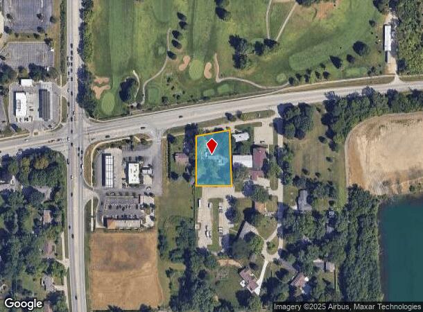
Property Record
32W901 State Route 68, Dundee, IL 60118
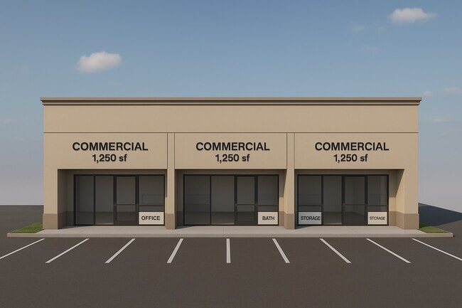
Current Lease Availabilities
NEARBY LISTINGS FOR SALE OR LEASE
Property Detail
32W901 State Route 68
Chicago-Naperville-Elgin, IL-IN-WI
Bonnie Acres
03-24-151-008
Kane
Sfr
Illinois
X
0.98 AC
17089C0157H
Far Northwest
1,328 SF
Chicago
DEMOGRAPHICS near 32W901 State Route 68
1 Mile
3 Mile
5 Mile
2024 Total Population
9,534
46,145
133,178
2029 Population
9,641
46,556
134,299
Pop Growth 2024-2029
+ 1.12%
+ 0.89%
+ 0.84%
Average Age
37
38
39
2024 Total Households
3,108
15,194
44,952
HH Growth 2024-2029
+ 1.25%
+ 0.95%
+ 0.83%
Median Household Inc
$75,405
$84,536
$93,324
Avg Household Size
3.00
3.00
2.90
2024 Avg HH Vehicles
2.00
2.00
2.00
Median Home Value
$256,017
$256,955
$282,467
Median Year Built
1968
1973
1979
Nearby Places
- Restaurants
- Banks
- Shops
- Fitness
- Groceries
PUBLIC TRANSPORTATION
COMMUTER RAIL
Elgin Station (Milwaukee District West Line - Northeast Illinois Regional Commuter Railroad (Metra))
DRIVE
WALK
Distance
Elgin Station (Milwaukee District West Line - Northeast Illinois Regional Commuter Railroad (Metra))
11 min
5.6 mi
Big Timber Road Station (Milwaukee District West Line - Northeast Illinois Regional Commuter Railroad (Metra))
DRIVE
WALK
Distance
Big Timber Road Station (Milwaukee District West Line - Northeast Illinois Regional Commuter Railroad (Metra))
13 min
6.6 mi
AIRPORT
Chicago O'Hare International
DRIVE
WALK
Distance
Chicago O'Hare International
35 min
25.9 mi
Freight Ports
Port Milwaukee
DRIVE
WALK
Distance
Port Milwaukee
104 min
77.5 mi
Nearby Properties
Address
Land Use
TOTAL SIZE
Lot Size
Zoning
Address
Land Use
TOTAL SIZE
Lot Size
Zoning
551,248 SF
28.94 AC
Address
Land Use
TOTAL SIZE
Lot Size
Zoning
23.54 AC
Address
Land Use
TOTAL SIZE
Lot Size
Zoning
431,318 SF
20 AC
Address
Land Use
TOTAL SIZE
Lot Size
Zoning
Address
Land Use
TOTAL SIZE
Lot Size
Zoning
2,415,708 SF
124.06 AC
Address
Land Use
TOTAL SIZE
Lot Size
Zoning
183,924 SF
0.80 AC
Address
Land Use
TOTAL SIZE
Lot Size
Zoning
211,680 SF
11.60 AC
Address
Land Use
TOTAL SIZE
Lot Size
Zoning
211,680 SF
11.34 AC
Address
Land Use
TOTAL SIZE
Lot Size
Zoning
23.38 AC
Address
Land Use
TOTAL SIZE
Lot Size
Zoning
176,799 SF
10 AC
Address
Land Use
TOTAL SIZE
Lot Size
Zoning
71,725 SF
49.30 AC
Address
Land Use
TOTAL SIZE
Lot Size
Zoning
154,483 SF
10 AC
Address
Land Use
TOTAL SIZE
Lot Size
Zoning
Address
Land Use
TOTAL SIZE
Lot Size
Zoning
Address
Land Use
TOTAL SIZE
Lot Size
Zoning
126,314 SF
11.58 AC
Address
Land Use
TOTAL SIZE
Lot Size
Zoning
151,977 SF
7 AC
Address
Land Use
TOTAL SIZE
Lot Size
Zoning
193,530 SF
0.57 AC
Address
Land Use
TOTAL SIZE
Lot Size
Zoning
120,075 SF
10.70 AC
Address
Land Use
TOTAL SIZE
Lot Size
Zoning
Address
Land Use
TOTAL SIZE
Lot Size
Zoning
1.30 AC
Address
Land Use
TOTAL SIZE
Lot Size
Zoning
Address
Land Use
TOTAL SIZE
Lot Size
Zoning
23.97 AC
Address
Land Use
TOTAL SIZE
Lot Size
Zoning
168,802 SF
0.50 AC
Address
Land Use
TOTAL SIZE
Lot Size
Zoning
1.36 AC
Address
Land Use
TOTAL SIZE
Lot Size
Zoning
7,200 SF
16.86 AC
Address
Land Use
TOTAL SIZE
Lot Size
Zoning
32,540 SF
8.08 AC
Address
Land Use
TOTAL SIZE
Lot Size
Zoning
106,488 SF
5.60 AC
Address
Land Use
TOTAL SIZE
Lot Size
Zoning
110,400 SF
5 AC
Address
Land Use
TOTAL SIZE
Lot Size
Zoning
35.28 AC
The World's #1 Commercial Real Estate Marketplace
Connect with us
© 2025 CoStar Group
The information above has been obtained from sources believed reliable. While we do not doubt its accuracy we have not verified it and make no guarantee, warranty or representation about it. It is your responsibility to independently confirm its accuracy and completeness. Any projections, opinions, assumptions, or estimates used are for example only and do not represent the current or future performance of the property. The value of this transaction to you depends on tax and other factors which should be evaluated by your tax, financial, and legal advisors. You and your advisors should conduct a careful, independent investigation of the property to determine to your satisfaction the suitability of the property for your needs.