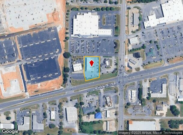
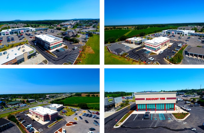
Property Record
8042 Highway 72 W, Madison, AL 35758

NEARBY LISTINGS FOR SALE OR LEASE
Property Detail
8042 Highway 72 W
Huntsville, AL
Jack Clift Addition
15-09-29-0-001-003.003
LOT 3 JACK CLIFT SUBDIVISION 6TH ADDITION PB #20160729000424170
Autorepair
Madison
X
Alabama
01089C0144F
3
2025
0.91 AC
2025
North Huntsville
010612
Huntsville
7,380 SF
DEMOGRAPHICS near 8042 Highway 72 W
1 Mile
3 Mile
5 Mile
2024 Total Population
5,257
50,380
117,350
2029 Population
5,816
56,083
131,448
Pop Growth 2024-2029
+ 10.63%
+ 11.32%
+ 12.01%
Average Age
41
40
39
2024 Total Households
1,974
19,126
46,645
HH Growth 2024-2029
+ 11.14%
+ 11.80%
+ 12.49%
Median Household Inc
$105,799
$108,477
$98,269
Avg Household Size
2.60
2.60
2.40
2024 Avg HH Vehicles
2.00
2.00
2.00
Median Home Value
$278,275
$294,434
$287,729
Median Year Built
1999
2001
2001
Nearby Places
Map Layers
Map Styles
 Street
 Aerial
- Restaurants
- Banks
- Shops
- Fitness
- Groceries
PUBLIC TRANSPORTATION
AIRPORT
Huntsville International-Carl T Jones Field
DRIVE
WALK
Distance
Huntsville International-Carl T Jones Field
19 min
9.3 mi
Freight Ports
Port of Mobile
DRIVE
WALK
Distance
Port of Mobile
387 min
350.5 mi
SALE & LEASE HISTORY
LISTING DATE
SALE/LEASE

Sep 19, 2017
For Sale
Nearby Properties
Address
Land Use
TOTAL SIZE
Lot Size
Zoning
Address
Land Use
TOTAL SIZE
Lot Size
Zoning
25,692 SF
11.77 AC
Address
Land Use
TOTAL SIZE
Lot Size
Zoning
14,008 SF
19 AC
Address
Land Use
TOTAL SIZE
Lot Size
Zoning
4,367 SF
27 AC
Address
Land Use
TOTAL SIZE
Lot Size
Zoning
7,055 SF
19 AC
Address
Land Use
TOTAL SIZE
Lot Size
Zoning
3,746 SF
22.08 AC
Address
Land Use
TOTAL SIZE
Lot Size
Zoning
8,868 SF
25 AC
Address
Land Use
TOTAL SIZE
Lot Size
Zoning
3,363 SF
26.88 AC
Address
Land Use
TOTAL SIZE
Lot Size
Zoning
9,138 SF
27 AC
Address
Land Use
TOTAL SIZE
Lot Size
Zoning
3,257 SF
25.84 AC
Address
Land Use
TOTAL SIZE
Lot Size
Zoning
2,774 SF
16 AC
Address
Land Use
TOTAL SIZE
Lot Size
Zoning
7,529 SF
16 AC
Address
Land Use
TOTAL SIZE
Lot Size
Zoning
4,324 SF
38 AC
Address
Land Use
TOTAL SIZE
Lot Size
Zoning
8,468 SF
5.80 AC
Address
Land Use
TOTAL SIZE
Lot Size
Zoning
8,258 SF
15.30 AC
Address
Land Use
TOTAL SIZE
Lot Size
Zoning
5,062 SF
20 AC
Address
Land Use
TOTAL SIZE
Lot Size
Zoning
3,976 SF
11.20 AC
Address
Land Use
TOTAL SIZE
Lot Size
Zoning
49,380 SF
6.18 AC
Address
Land Use
TOTAL SIZE
Lot Size
Zoning
5,600 SF
17.16 AC
Address
Land Use
TOTAL SIZE
Lot Size
Zoning
6,220 SF
6.20 AC
Address
Land Use
TOTAL SIZE
Lot Size
Zoning
86,280 SF
18.90 AC
Address
Land Use
TOTAL SIZE
Lot Size
Zoning
22,171 SF
Address
Land Use
TOTAL SIZE
Lot Size
Zoning
56,025 SF
9.34 AC
Address
Land Use
TOTAL SIZE
Lot Size
Zoning
62,384 SF
31.04 AC
Address
Land Use
TOTAL SIZE
Lot Size
Zoning
178,255 SF
19.39 AC
Address
Land Use
TOTAL SIZE
Lot Size
Zoning
39,385 SF
4.52 AC
Address
Land Use
TOTAL SIZE
Lot Size
Zoning
138,920 SF
9.53 AC
Address
Land Use
TOTAL SIZE
Lot Size
Zoning
99,792 SF
8.72 AC
Address
Land Use
TOTAL SIZE
Lot Size
Zoning
57,905 SF
10.26 AC
Address
Land Use
TOTAL SIZE
Lot Size
Zoning
16,768 SF
2.52 AC
Address
Land Use
TOTAL SIZE
Lot Size
Zoning
82,310 SF
4.24 AC
The World's #1 Commercial Real Estate Marketplace
Connect with us
© 2025 CoStar Group
The information above has been obtained from sources believed reliable. While we do not doubt its accuracy we have not verified it and make no guarantee, warranty or representation about it. It is your responsibility to independently confirm its accuracy and completeness. Any projections, opinions, assumptions, or estimates used are for example only and do not represent the current or future performance of the property. The value of this transaction to you depends on tax and other factors which should be evaluated by your tax, financial, and legal advisors. You and your advisors should conduct a careful, independent investigation of the property to determine to your satisfaction the suitability of the property for your needs.