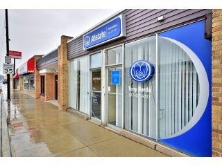
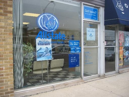
Property Record
8045 N Milwaukee Ave, Niles, IL 60714
NEARBY LISTINGS FOR SALE OR LEASE
Property Detail
8045 N Milwaukee Ave
Chicago-Naperville-Elgin, IL-IN-WI
First Add To Grennan Heights
09-24-419-007-0000
(FIRST) ADD TO (GRENNAN)(HEIGHTS) SUB PT OF LYING E M ILWAUKEE ROAD SH SH SE SEC 24-41-12
Commercialbuilding
Cook
X
Illinois
17031C0239J
541
2023
0.72 AC
2024
Near North
805402
Chicago
1,500 SF
DEMOGRAPHICS near 8045 N Milwaukee Ave
1 Mile
3 Mile
5 Mile
2024 Total Population
20,327
160,379
426,342
2029 Population
19,665
155,118
412,988
Pop Growth 2024-2029
(3.26%)
(3.28%)
(3.13%)
Average Age
43
44
43
2024 Total Households
7,379
59,856
160,306
HH Growth 2024-2029
(3.65%)
(3.61%)
(3.46%)
Median Household Inc
$95,898
$94,997
$87,777
Avg Household Size
2.70
2.60
2.60
2024 Avg HH Vehicles
2.00
2.00
2.00
Median Home Value
$353,116
$378,569
$366,576
Median Year Built
1956
1959
1960
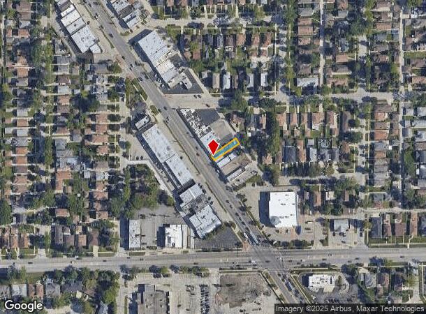
Nearby Places
Map Layers
Map Styles
 Street
 Aerial
- Restaurants
- Banks
- Shops
- Fitness
- Groceries
PUBLIC TRANSPORTATION
COMMUTER RAIL
Morton Grove Station (Milwaukee District North Line - Northeast Illinois Regional Commuter Railroad (Metra))
DRIVE
WALK
Distance
Morton Grove Station (Milwaukee District North Line - Northeast Illinois Regional Commuter Railroad (Metra))
5 min
2.4 mi
Park Ridge Station (Union Pacific Northwest Line - Northeast Illinois Regional Commuter Railroad (Metra))
DRIVE
WALK
Distance
Park Ridge Station (Union Pacific Northwest Line - Northeast Illinois Regional Commuter Railroad (Metra))
4 min
2.6 mi
AIRPORT
Chicago O'Hare International
DRIVE
WALK
Distance
Chicago O'Hare International
14 min
8.4 mi
Chicago Midway International
DRIVE
WALK
Distance
Chicago Midway International
33 min
18.4 mi
Freight Ports
Port Milwaukee
DRIVE
WALK
Distance
Port Milwaukee
87 min
73.6 mi
SALE & LEASE HISTORY
LISTING DATE
SALE/LEASE

Jan 23, 2017
For Sale
Nearby Properties
Address
Land Use
TOTAL SIZE
Lot Size
Zoning
Address
Land Use
TOTAL SIZE
Lot Size
Zoning
203,090 SF
7.96 AC
Address
Land Use
TOTAL SIZE
Lot Size
Zoning
24.49 AC
Address
Land Use
TOTAL SIZE
Lot Size
Zoning
39.26 AC
Address
Land Use
TOTAL SIZE
Lot Size
Zoning
188,728 SF
Address
Land Use
TOTAL SIZE
Lot Size
Zoning
10.24 AC
Address
Land Use
TOTAL SIZE
Lot Size
Zoning
414,878 SF
20.79 AC
Address
Land Use
TOTAL SIZE
Lot Size
Zoning
315,373 SF
26.19 AC
Address
Land Use
TOTAL SIZE
Lot Size
Zoning
269,500 SF
11.03 AC
Address
Land Use
TOTAL SIZE
Lot Size
Zoning
103,323 SF
10.65 AC
Address
Land Use
TOTAL SIZE
Lot Size
Zoning
16.27 AC
Address
Land Use
TOTAL SIZE
Lot Size
Zoning
611,799 SF
17.61 AC
Address
Land Use
TOTAL SIZE
Lot Size
Zoning
486,884 SF
16.41 AC
Address
Land Use
TOTAL SIZE
Lot Size
Zoning
450,768 SF
6.97 AC
Address
Land Use
TOTAL SIZE
Lot Size
Zoning
552,152 SF
7.88 AC
Address
Land Use
TOTAL SIZE
Lot Size
Zoning
5.60 AC
Address
Land Use
TOTAL SIZE
Lot Size
Zoning
276,112 SF
10.02 AC
Address
Land Use
TOTAL SIZE
Lot Size
Zoning
13.13 AC
Address
Land Use
TOTAL SIZE
Lot Size
Zoning
320,535 SF
12.44 AC
Address
Land Use
TOTAL SIZE
Lot Size
Zoning
166,728 SF
11.79 AC
Address
Land Use
TOTAL SIZE
Lot Size
Zoning
59,013 SF
1.90 AC
Address
Land Use
TOTAL SIZE
Lot Size
Zoning
195,849 SF
6.55 AC
Address
Land Use
TOTAL SIZE
Lot Size
Zoning
92,457 SF
4.09 AC
Address
Land Use
TOTAL SIZE
Lot Size
Zoning
629,244 SF
11.07 AC
RS-2
Address
Land Use
TOTAL SIZE
Lot Size
Zoning
424,257 SF
Address
Land Use
TOTAL SIZE
Lot Size
Zoning
189,892 SF
Address
Land Use
TOTAL SIZE
Lot Size
Zoning
122,489 SF
9.92 AC
Address
Land Use
TOTAL SIZE
Lot Size
Zoning
284,708 SF
17.74 AC
Address
Land Use
TOTAL SIZE
Lot Size
Zoning
358,324 SF
16.05 AC
Address
Land Use
TOTAL SIZE
Lot Size
Zoning
23.45 AC
Address
Land Use
TOTAL SIZE
Lot Size
Zoning
333,078 SF
9.15 AC
The World's #1 Commercial Real Estate Marketplace
Connect with us
© 2025 CoStar Group
The information above has been obtained from sources believed reliable. While we do not doubt its accuracy we have not verified it and make no guarantee, warranty or representation about it. It is your responsibility to independently confirm its accuracy and completeness. Any projections, opinions, assumptions, or estimates used are for example only and do not represent the current or future performance of the property. The value of this transaction to you depends on tax and other factors which should be evaluated by your tax, financial, and legal advisors. You and your advisors should conduct a careful, independent investigation of the property to determine to your satisfaction the suitability of the property for your needs.