Property Record
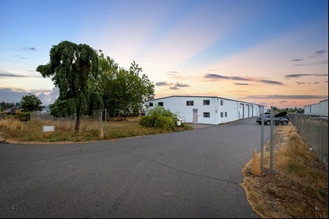
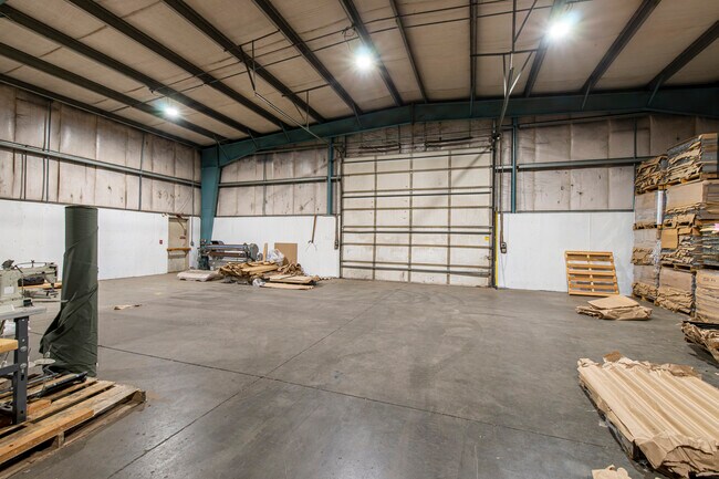
8045 State St, Salem, OR 97317


Property Detail
8045 State St
523690
ACRES 1.42
Officebuilding
Marion
I
Oregon
B and X Area of moderate flood hazard, usually the area between the limits of the 100-year and 500-year floods.
1.42 AC
2024
Marion County
2025
Portland
002600
Salem, OR
17,580 SF
NEARBY LISTINGS FOR SALE OR LEASE
DEMOGRAPHICS near 8045 State St
1 mile
3 mile
5 mile
2025 Total Population
288
5,892
63,642
2030 Population
283
5,822
63,935
Pop Growth 2025-2030
(1.74%)
(1.19%)
+ 0.46%
Average Age
46
44
38
2025 Total Households
101
2,049
21,254
HH Growth 2025-2030
(0.99%)
(1.07%)
+ 0.59%
Median Household Inc
$111,718
$100,955
$69,553
Avg Household Size
2.80
2.80
2.80
2025 Avg HH Vehicles
3.00
3.00
2.00
Median Home Value
$726,923
$669,643
$363,978
Median Year Built
1973
1975
1979
Nearby Places
Map Layers
Map Styles
 Street
 Aerial
Transit
 Traffic
 Biking
Places
Listings with unknown addresses are not visible on the map
- Restaurants
- Banks
- Shops
- Fitness
- Groceries
PUBLIC TRANSPORTATION
COMMUTER RAIL
Drive
Walk
Distance
15 min
7.6 mi
Freight Ports
Port of Portland
Drive
Walk
Distance
Port of Portland
73 min
54.3 mi
SALE & LEASE HISTORY
LISTING DATE
SALE/LEASE

Oct 06, 2022
For Sale
Nov 13, 2017
For Sale
Nearby Properties
Address
Land Use
TOTAL SIZE
Lot Size
Zoning
Address
Land Use
TOTAL SIZE
Lot Size
Zoning
152,237 SF
8.16 AC
RM2; RM1
Address
Land Use
TOTAL SIZE
Lot Size
Zoning
129,850 SF
19.66 AC
IBC
Address
Land Use
TOTAL SIZE
Lot Size
Zoning
5.15 AC
EFU
Address
Land Use
TOTAL SIZE
Lot Size
Zoning
61,717 SF
19.24 AC
I
Address
Land Use
TOTAL SIZE
Lot Size
Zoning
Address
Land Use
TOTAL SIZE
Lot Size
Zoning
32,279 SF
8.15 AC
AR
Address
Land Use
TOTAL SIZE
Lot Size
Zoning
Address
Land Use
TOTAL SIZE
Lot Size
Zoning
63,539 SF
5.97 AC
I; EFU
Address
Land Use
TOTAL SIZE
Lot Size
Zoning
Address
Land Use
TOTAL SIZE
Lot Size
Zoning
325 SF
37.58 AC
P; I
Address
Land Use
TOTAL SIZE
Lot Size
Zoning
31,046 SF
12.69 AC
EFU
Address
Land Use
TOTAL SIZE
Lot Size
Zoning
16,304 SF
6.32 AC
I
Address
Land Use
TOTAL SIZE
Lot Size
Zoning
43,714 SF
20.54 AC
EFU
Address
Land Use
TOTAL SIZE
Lot Size
Zoning
19,079 SF
31.45 AC
EFU
Address
Land Use
TOTAL SIZE
Lot Size
Zoning
16,479 SF
367.39 AC
EFU
Address
Land Use
TOTAL SIZE
Lot Size
Zoning
51,794 SF
101.80 AC
EFU
Address
Land Use
TOTAL SIZE
Lot Size
Zoning
37,402 SF
3.01 AC
I
Address
Land Use
TOTAL SIZE
Lot Size
Zoning
19,360 SF
4.23 AC
C
Address
Land Use
TOTAL SIZE
Lot Size
Zoning
30,528 SF
2.50 AC
I
Address
Land Use
TOTAL SIZE
Lot Size
Zoning
1,960 SF
3.46 AC
C
Address
Land Use
TOTAL SIZE
Lot Size
Zoning
3,780 SF
2.65 AC
Address
Land Use
TOTAL SIZE
Lot Size
Zoning
34,068 SF
5.40 AC
C
Address
Land Use
TOTAL SIZE
Lot Size
Zoning
41,437 SF
30.45 AC
SA
Address
Land Use
TOTAL SIZE
Lot Size
Zoning
25,760 SF
5.96 AC
EFU
Address
Land Use
TOTAL SIZE
Lot Size
Zoning
11,164 SF
7.70 AC
I
Address
Land Use
TOTAL SIZE
Lot Size
Zoning
8,322 SF
62.06 AC
EFU
Address
Land Use
TOTAL SIZE
Lot Size
Zoning
3,153 SF
2.66 AC
AR
Address
Land Use
TOTAL SIZE
Lot Size
Zoning
10.12 AC
IG
Address
Land Use
TOTAL SIZE
Lot Size
Zoning
6,870 SF
101.30 AC
EFU
The World's #1 Commercial Real Estate Marketplace
Connect with us
© 2026 CoStar Group
The information above has been obtained from sources believed reliable. While we do not doubt its accuracy we have not verified it and make no guarantee, warranty or representation about it. It is your responsibility to independently confirm its accuracy and completeness. Any projections, opinions, assumptions, or estimates used are for example only and do not represent the current or future performance of the property. The value of this transaction to you depends on tax and other factors which should be evaluated by your tax, financial, and legal advisors. You and your advisors should conduct a careful, independent investigation of the property to determine to your satisfaction the suitability of the property for your needs.