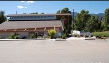
Property Record
8046 W Us Highway 50, Salida, CO 81201

Property Detail
8046 W Us Highway 50
R380501400030
PT SE4SE4 1-49-8 REC 451750 451751
Restaurantbuilding
Chaffee
AE The base floodplain where base flood elevations are provided. AE Zones are now used on new format FIRMs instead of A1-A30 Zones.
Colorado
2024
0.67 AC
2025
Colorado Southwest Area
000200
Other Market Areas
4,314 SF
NEARBY LISTINGS FOR SALE OR LEASE
-
-
-
No Photo
-
View all Salida listings for sale on LoopNet.com
DEMOGRAPHICS near 8046 W Us Highway 50
1 mile
3 mile
5 mile
2025 Total Population
1,011
8,672
9,820
2030 Population
1,046
9,107
10,319
Pop Growth 2025-2030
+ 3.46%
+ 5.02%
+ 5.08%
Average Age
47
46
46
2025 Total Households
467
4,117
4,647
HH Growth 2025-2030
+ 3.85%
+ 5.37%
+ 5.44%
Median Household Inc
$86,000
$76,377
$75,581
Avg Household Size
2.10
2.10
2.10
2025 Avg HH Vehicles
2.00
2.00
2.00
Median Home Value
$685,185
$700,405
$697,460
Median Year Built
1992
1992
1993
Nearby Places
Map Layers
Map Styles
 Street
 Aerial
Transit
 Traffic
 Biking
Places
Listings with unknown addresses are not visible on the map
- Restaurants
- Banks
- Shops
- Fitness
- Groceries
SALE & LEASE HISTORY
LISTING DATE
SALE/LEASE

Sep 23, 2016
For Sale
Jul 26, 2017
For Sale
Nearby Properties
Address
Land Use
TOTAL SIZE
Lot Size
Zoning
Address
Land Use
TOTAL SIZE
Lot Size
Zoning
151,598 SF
44.85 AC
Address
Land Use
TOTAL SIZE
Lot Size
Zoning
108,995 SF
11.97 AC
Address
Land Use
TOTAL SIZE
Lot Size
Zoning
26,676 SF
4 AC
Address
Land Use
TOTAL SIZE
Lot Size
Zoning
72,851 SF
3.75 AC
Address
Land Use
TOTAL SIZE
Lot Size
Zoning
55,708 SF
5.90 AC
Address
Land Use
TOTAL SIZE
Lot Size
Zoning
56,438 SF
5.56 AC
Address
Land Use
TOTAL SIZE
Lot Size
Zoning
109,252 SF
14.06 AC
Address
Land Use
TOTAL SIZE
Lot Size
Zoning
75,461 SF
2.50 AC
Address
Land Use
TOTAL SIZE
Lot Size
Zoning
33,299 SF
3.26 AC
Address
Land Use
TOTAL SIZE
Lot Size
Zoning
3,575 SF
19.10 AC
Address
Land Use
TOTAL SIZE
Lot Size
Zoning
780 SF
10.50 AC
Address
Land Use
TOTAL SIZE
Lot Size
Zoning
15,538 SF
3.85 AC
Address
Land Use
TOTAL SIZE
Lot Size
Zoning
64,634 SF
2.61 AC
Address
Land Use
TOTAL SIZE
Lot Size
Zoning
30,280 SF
1.96 AC
Address
Land Use
TOTAL SIZE
Lot Size
Zoning
32,312 SF
1.84 AC
Address
Land Use
TOTAL SIZE
Lot Size
Zoning
39,482 SF
2.35 AC
Address
Land Use
TOTAL SIZE
Lot Size
Zoning
28,378 SF
1.46 AC
Address
Land Use
TOTAL SIZE
Lot Size
Zoning
32,100 SF
1.33 AC
Address
Land Use
TOTAL SIZE
Lot Size
Zoning
19,384 SF
3.50 AC
Address
Land Use
TOTAL SIZE
Lot Size
Zoning
55,512 SF
4.19 AC
Address
Land Use
TOTAL SIZE
Lot Size
Zoning
11,136 SF
0.40 AC
Address
Land Use
TOTAL SIZE
Lot Size
Zoning
23,892 SF
0.69 AC
Address
Land Use
TOTAL SIZE
Lot Size
Zoning
35,395 SF
2.96 AC
Address
Land Use
TOTAL SIZE
Lot Size
Zoning
5,340 SF
8.22 AC
Address
Land Use
TOTAL SIZE
Lot Size
Zoning
42,467 SF
6.10 AC
Address
Land Use
TOTAL SIZE
Lot Size
Zoning
14,077 SF
52.80 AC
Address
Land Use
TOTAL SIZE
Lot Size
Zoning
21,700 SF
20 AC
Address
Land Use
TOTAL SIZE
Lot Size
Zoning
24,434 SF
1.70 AC
Address
Land Use
TOTAL SIZE
Lot Size
Zoning
13,651 SF
1.15 AC
Address
Land Use
TOTAL SIZE
Lot Size
Zoning
20,576 SF
0.90 AC
The World's #1 Commercial Real Estate Marketplace
Connect with us
© 2026 CoStar Group
The information above has been obtained from sources believed reliable. While we do not doubt its accuracy we have not verified it and make no guarantee, warranty or representation about it. It is your responsibility to independently confirm its accuracy and completeness. Any projections, opinions, assumptions, or estimates used are for example only and do not represent the current or future performance of the property. The value of this transaction to you depends on tax and other factors which should be evaluated by your tax, financial, and legal advisors. You and your advisors should conduct a careful, independent investigation of the property to determine to your satisfaction the suitability of the property for your needs.