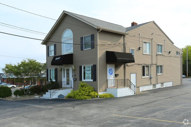
Property Record
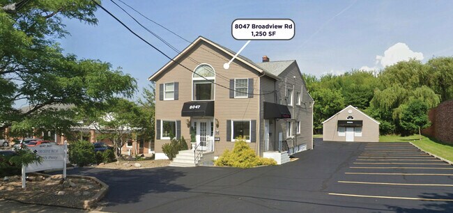
8047 Broadview Rd, Broadview Heights, OH 44147

NEARBY LISTINGS FOR SALE OR LEASE
Property Detail
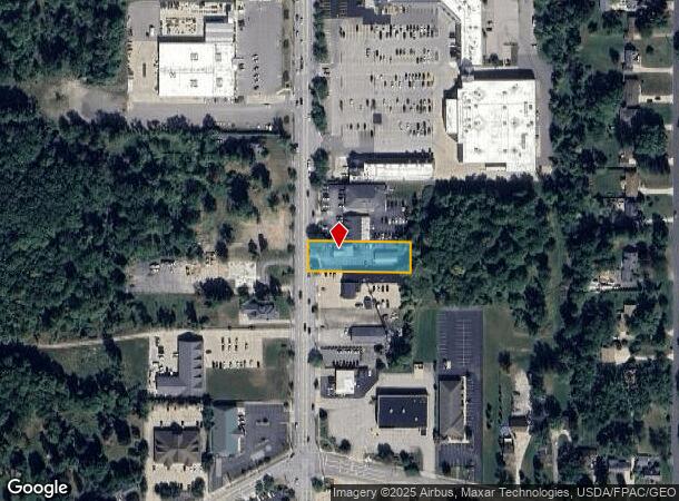
8047 Broadview Rd
Cleveland
Brecksville
Cleveland-Elyria, OH
5 NP 573.87 N OF CL WALLINGS
581-23-011
Cuyahoga
Storesoffices
Ohio
2024
5
2024
0.43 AC
136103
South
5,269 SF
DEMOGRAPHICS near 8047 Broadview Rd
1 mile
3 mile
5 mile
2024 Total Population
5,560
48,898
144,573
2029 Population
5,337
47,250
140,173
Pop Growth 2024-2029
(4.01%)
(3.37%)
(3.04%)
Average Age
46
45
44
2024 Total Households
2,315
19,992
61,201
HH Growth 2024-2029
(4.23%)
(3.60%)
(3.22%)
Median Household Inc
$86,384
$87,133
$74,281
Avg Household Size
2.40
2.40
2.30
2024 Avg HH Vehicles
2.00
2.00
2.00
Median Home Value
$228,642
$233,966
$192,114
Median Year Built
1968
1969
1964
Nearby Places
Map Layers
Map Styles
 Street
 Aerial
Transit
 Traffic
 Biking
Places
Listings with unknown addresses are not visible on the map
- Restaurants
- Banks
- Shops
- Fitness
- Groceries
SALE & LEASE HISTORY
LISTING DATE
SALE/LEASE

Oct 18, 2016
For Lease
Jul 28, 2020
For Lease
Jul 27, 2020
For Lease
Jul 01, 2020
For Lease
Dec 11, 2017
For Lease
Nearby Properties
Address
Land Use
TOTAL SIZE
Lot Size
Zoning
Address
Land Use
TOTAL SIZE
Lot Size
Zoning
202,152 SF
21.04 AC
U-1
Address
Land Use
TOTAL SIZE
Lot Size
Zoning
238,500 SF
20.31 AC
SC
Address
Land Use
TOTAL SIZE
Lot Size
Zoning
162,134 SF
12.24 AC
CG
Address
Land Use
TOTAL SIZE
Lot Size
Zoning
285,065 SF
5.43 AC
D-1
Address
Land Use
TOTAL SIZE
Lot Size
Zoning
281,600 SF
18.73 AC
SF-A
Address
Land Use
TOTAL SIZE
Lot Size
Zoning
166,699 SF
65.80 AC
B-5
Address
Land Use
TOTAL SIZE
Lot Size
Zoning
137,178 SF
8.62 AC
Address
Land Use
TOTAL SIZE
Lot Size
Zoning
48,682 SF
4.64 AC
C-4
Address
Land Use
TOTAL SIZE
Lot Size
Zoning
63,282 SF
20.09 AC
O-B
Address
Land Use
TOTAL SIZE
Lot Size
Zoning
28,189 SF
15.33 AC
B-1OR2
Address
Land Use
TOTAL SIZE
Lot Size
Zoning
162,134 SF
13.35 AC
CG
Address
Land Use
TOTAL SIZE
Lot Size
Zoning
124,224 SF
25.99 AC
U-1
Address
Land Use
TOTAL SIZE
Lot Size
Zoning
238,500 SF
20.89 AC
SC
Address
Land Use
TOTAL SIZE
Lot Size
Zoning
56,002 SF
6.76 AC
U-5
Address
Land Use
TOTAL SIZE
Lot Size
Zoning
180,095 SF
26.26 AC
SF-AA
Address
Land Use
TOTAL SIZE
Lot Size
Zoning
126,224 SF
5.31 AC
RB
Address
Land Use
TOTAL SIZE
Lot Size
Zoning
188,503 SF
23.72 AC
D-1
Address
Land Use
TOTAL SIZE
Lot Size
Zoning
24,900 SF
4.42 AC
B-1OR2
Address
Land Use
TOTAL SIZE
Lot Size
Zoning
55,332 SF
3.01 AC
E-2
Address
Land Use
TOTAL SIZE
Lot Size
Zoning
89,807 SF
7.29 AC
Address
Land Use
TOTAL SIZE
Lot Size
Zoning
49,470 SF
6.61 AC
E-1
Address
Land Use
TOTAL SIZE
Lot Size
Zoning
83,495 SF
9.70 AC
E-1
Address
Land Use
TOTAL SIZE
Lot Size
Zoning
142,510 SF
13.87 AC
E-2
Address
Land Use
TOTAL SIZE
Lot Size
Zoning
59,813 SF
5.56 AC
Address
Land Use
TOTAL SIZE
Lot Size
Zoning
72,957 SF
11.48 AC
1F-3
Address
Land Use
TOTAL SIZE
Lot Size
Zoning
49,388 SF
29.19 AC
C-F
Address
Land Use
TOTAL SIZE
Lot Size
Zoning
49,811 SF
21.80 AC
A-1
Address
Land Use
TOTAL SIZE
Lot Size
Zoning
37,452 SF
16.24 AC
D-1
Address
Land Use
TOTAL SIZE
Lot Size
Zoning
123.70 AC
A-1
Address
Land Use
TOTAL SIZE
Lot Size
Zoning
96,600 SF
8.95 AC
MF-1
The World's #1 Commercial Real Estate Marketplace
Connect with us
© 2026 CoStar Group
The information above has been obtained from sources believed reliable. While we do not doubt its accuracy we have not verified it and make no guarantee, warranty or representation about it. It is your responsibility to independently confirm its accuracy and completeness. Any projections, opinions, assumptions, or estimates used are for example only and do not represent the current or future performance of the property. The value of this transaction to you depends on tax and other factors which should be evaluated by your tax, financial, and legal advisors. You and your advisors should conduct a careful, independent investigation of the property to determine to your satisfaction the suitability of the property for your needs.