Property Record
8047 Parallel Pky, Kansas City, KS 66112
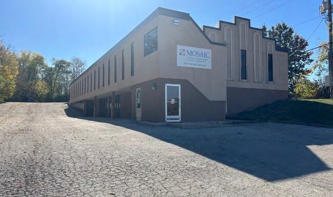

This Property Is For Sale
NEARBY LISTINGS FOR SALE OR LEASE
Property Detail
8047 Parallel Pky
931015
SEC-05 TWP-11 RNG-24, S5, T11, R24, ACRES 0.930000, 370D3 BEG 50FT S OF NW COR E1/2 E1/2 W1/2 NE1/4; E 100FT, S 410FT, W 100FT, N 410FT TO POB CONTG 0.94AC M/L
Officebuilding
Wyandotte
X
Kansas
20103C0275G
0.95 AC
0
Kansas City KS
2025
Kansas City
044103
Kansas City, MO-KS
11,490 SF
DEMOGRAPHICS near 8047 Parallel Pky
1 Mile
3 Mile
5 Mile
2024 Total Population
9,987
35,180
62,267
2029 Population
9,662
34,182
60,476
Pop Growth 2024-2029
(3.25%)
(2.84%)
(2.88%)
Average Age
40
39
38
2024 Total Households
3,912
13,327
23,198
HH Growth 2024-2029
(3.27%)
(2.83%)
(2.93%)
Median Household Inc
$58,673
$59,435
$62,921
Avg Household Size
2.50
2.50
2.60
2024 Avg HH Vehicles
2.00
2.00
2.00
Median Home Value
$153,891
$154,943
$159,214
Median Year Built
1969
1967
1968
Nearby Places
Map Layers
Map Styles
 Street
 Aerial
- Restaurants
- Banks
- Shops
- Fitness
- Groceries
PUBLIC TRANSPORTATION
AIRPORT
Kansas City International
DRIVE
WALK
Distance
Kansas City International
31 min
22.8 mi
Nearby Properties
Address
Land Use
TOTAL SIZE
Lot Size
Zoning
Address
Land Use
TOTAL SIZE
Lot Size
Zoning
872,064 SF
119.39 AC
Address
Land Use
TOTAL SIZE
Lot Size
Zoning
123,957 SF
16.88 AC
Address
Land Use
TOTAL SIZE
Lot Size
Zoning
542,696 SF
28.12 AC
Address
Land Use
TOTAL SIZE
Lot Size
Zoning
264,254 SF
56.62 AC
KR1
Address
Land Use
TOTAL SIZE
Lot Size
Zoning
309,440 SF
120.73 AC
KR1
Address
Land Use
TOTAL SIZE
Lot Size
Zoning
51,739 SF
46.71 AC
Address
Land Use
TOTAL SIZE
Lot Size
Zoning
346,224 SF
28.44 AC
Address
Land Use
TOTAL SIZE
Lot Size
Zoning
407,936 SF
37.46 AC
1
Address
Land Use
TOTAL SIZE
Lot Size
Zoning
37,521 SF
11.77 AC
Address
Land Use
TOTAL SIZE
Lot Size
Zoning
108,385 SF
22.86 AC
KAG
Address
Land Use
TOTAL SIZE
Lot Size
Zoning
396,532 SF
31.98 AC
Address
Land Use
TOTAL SIZE
Lot Size
Zoning
75,027 SF
13.51 AC
Address
Land Use
TOTAL SIZE
Lot Size
Zoning
241,816 SF
20.03 AC
Address
Land Use
TOTAL SIZE
Lot Size
Zoning
224,020 SF
24.72 AC
KR1
Address
Land Use
TOTAL SIZE
Lot Size
Zoning
88,396 SF
23.79 AC
Address
Land Use
TOTAL SIZE
Lot Size
Zoning
1,099,964 SF
115.80 AC
Address
Land Use
TOTAL SIZE
Lot Size
Zoning
48,278 SF
14.62 AC
Address
Land Use
TOTAL SIZE
Lot Size
Zoning
54,578 SF
12.01 AC
KR1
Address
Land Use
TOTAL SIZE
Lot Size
Zoning
186,293 SF
63.45 AC
Address
Land Use
TOTAL SIZE
Lot Size
Zoning
139,495 SF
35.01 AC
KR1
Address
Land Use
TOTAL SIZE
Lot Size
Zoning
158,011 SF
26.66 AC
Address
Land Use
TOTAL SIZE
Lot Size
Zoning
437,300 SF
50.66 AC
Address
Land Use
TOTAL SIZE
Lot Size
Zoning
39,012 SF
13.38 AC
Address
Land Use
TOTAL SIZE
Lot Size
Zoning
116,455 SF
16.49 AC
Address
Land Use
TOTAL SIZE
Lot Size
Zoning
40,016 SF
5.20 AC
Address
Land Use
TOTAL SIZE
Lot Size
Zoning
57,384 SF
18.81 AC
CPO
Address
Land Use
TOTAL SIZE
Lot Size
Zoning
1,036,732 SF
25.08 AC
KC1
Address
Land Use
TOTAL SIZE
Lot Size
Zoning
19,392 SF
2.77 AC
KCP1
Address
Land Use
TOTAL SIZE
Lot Size
Zoning
1,542 SF
48.61 AC
KR1
Address
Land Use
TOTAL SIZE
Lot Size
Zoning
239,205 SF
17.52 AC
The World's #1 Commercial Real Estate Marketplace
Connect with us
© 2026 CoStar Group
The information above has been obtained from sources believed reliable. While we do not doubt its accuracy we have not verified it and make no guarantee, warranty or representation about it. It is your responsibility to independently confirm its accuracy and completeness. Any projections, opinions, assumptions, or estimates used are for example only and do not represent the current or future performance of the property. The value of this transaction to you depends on tax and other factors which should be evaluated by your tax, financial, and legal advisors. You and your advisors should conduct a careful, independent investigation of the property to determine to your satisfaction the suitability of the property for your needs.