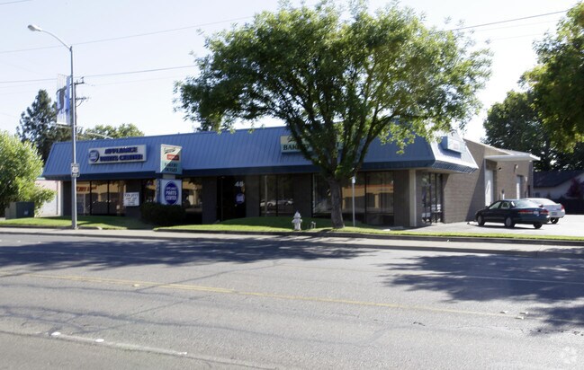
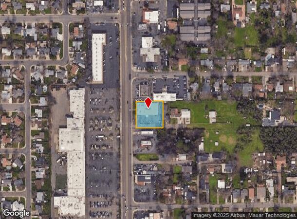
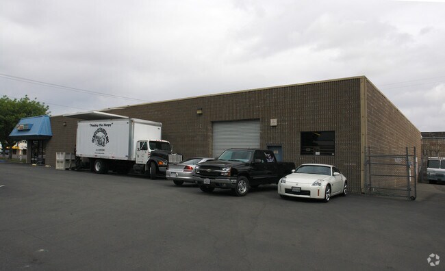
Property Record
8048 Auburn Blvd, Citrus Heights, CA 95610
NEARBY LISTINGS FOR SALE OR LEASE
Property Detail
8048 Auburn Blvd
Sacramento--Roseville--Arden-Arcade, CA
Parcel Map
204-0530-045
PCL 1 PM 49-1 EXC ROW PER BK 20171010 PG1010
Storebuilding
Sacramento
X
California
06067C0083J
1
2024
0.65 AC
2025
Orangevale/Citrus Hts
008143
Sacramento
10,240 SF
DEMOGRAPHICS near 8048 Auburn Blvd
1 Mile
3 Mile
5 Mile
2024 Total Population
17,123
135,666
362,990
2029 Population
17,283
138,617
371,728
Pop Growth 2024-2029
+ 0.93%
+ 2.18%
+ 2.41%
Average Age
39
41
40
2024 Total Households
6,577
51,682
135,299
HH Growth 2024-2029
+ 0.88%
+ 2.26%
+ 2.45%
Median Household Inc
$69,611
$77,684
$84,626
Avg Household Size
2.60
2.60
2.60
2024 Avg HH Vehicles
2.00
2.00
2.00
Median Home Value
$395,476
$429,162
$462,063
Median Year Built
1975
1977
1980
Nearby Places
Map Layers
Map Styles
 Street
 Aerial
- Restaurants
- Banks
- Shops
- Fitness
- Groceries
PUBLIC TRANSPORTATION
COMMUTER RAIL
DRIVE
WALK
Distance
9 min
3.3 mi
DRIVE
WALK
Distance
11 min
6.6 mi
AIRPORT
Sacramento International
DRIVE
WALK
Distance
Sacramento International
32 min
22.9 mi
SALE & LEASE HISTORY
LISTING DATE
SALE/LEASE

Sep 24, 2016
For Lease
Sep 24, 2016
For Sale
Nearby Properties
Address
Land Use
TOTAL SIZE
Lot Size
Zoning
Address
Land Use
TOTAL SIZE
Lot Size
Zoning
210,380 SF
14.26 AC
Address
Land Use
TOTAL SIZE
Lot Size
Zoning
187,369 SF
15.24 AC
RD20
Address
Land Use
TOTAL SIZE
Lot Size
Zoning
251,225 SF
23.54 AC
SC
Address
Land Use
TOTAL SIZE
Lot Size
Zoning
263,682 SF
14.40 AC
Address
Land Use
TOTAL SIZE
Lot Size
Zoning
78,730 SF
8.03 AC
RD20 BP
Address
Land Use
TOTAL SIZE
Lot Size
Zoning
128,480 SF
7.95 AC
RD30 BP
Address
Land Use
TOTAL SIZE
Lot Size
Zoning
58.14 AC
RD-2
Address
Land Use
TOTAL SIZE
Lot Size
Zoning
217,550 SF
21.31 AC
SPA
Address
Land Use
TOTAL SIZE
Lot Size
Zoning
4.90 AC
RD30
Address
Land Use
TOTAL SIZE
Lot Size
Zoning
2,080 SF
136.17 AC
FDR
Address
Land Use
TOTAL SIZE
Lot Size
Zoning
126,521 SF
11 AC
Address
Land Use
TOTAL SIZE
Lot Size
Zoning
156,365 SF
12.81 AC
SC
Address
Land Use
TOTAL SIZE
Lot Size
Zoning
166,268 SF
9.50 AC
RD30
Address
Land Use
TOTAL SIZE
Lot Size
Zoning
148,663 SF
13.19 AC
SPA
Address
Land Use
TOTAL SIZE
Lot Size
Zoning
98,508 SF
5.33 AC
RD20
Address
Land Use
TOTAL SIZE
Lot Size
Zoning
153,746 SF
15.20 AC
Address
Land Use
TOTAL SIZE
Lot Size
Zoning
111,185 SF
8.10 AC
Address
Land Use
TOTAL SIZE
Lot Size
Zoning
137,732 SF
12.87 AC
SC
Address
Land Use
TOTAL SIZE
Lot Size
Zoning
162,401 SF
5.29 AC
Address
Land Use
TOTAL SIZE
Lot Size
Zoning
268,502 SF
12.38 AC
RD30
Address
Land Use
TOTAL SIZE
Lot Size
Zoning
220,691 SF
18.28 AC
RD20
Address
Land Use
TOTAL SIZE
Lot Size
Zoning
141,279 SF
11.56 AC
SPA
Address
Land Use
TOTAL SIZE
Lot Size
Zoning
61,056 SF
4.50 AC
Address
Land Use
TOTAL SIZE
Lot Size
Zoning
288,524 SF
11.64 AC
M-1
Address
Land Use
TOTAL SIZE
Lot Size
Zoning
147,606 SF
11.80 AC
Address
Land Use
TOTAL SIZE
Lot Size
Zoning
3.72 AC
RD-5
Address
Land Use
TOTAL SIZE
Lot Size
Zoning
145,922 SF
11.90 AC
Address
Land Use
TOTAL SIZE
Lot Size
Zoning
116,817 SF
6.60 AC
Address
Land Use
TOTAL SIZE
Lot Size
Zoning
141,124 SF
17 AC
Address
Land Use
TOTAL SIZE
Lot Size
Zoning
131,535 SF
13.19 AC
SC
The World's #1 Commercial Real Estate Marketplace
Connect with us
© 2025 CoStar Group
The information above has been obtained from sources believed reliable. While we do not doubt its accuracy we have not verified it and make no guarantee, warranty or representation about it. It is your responsibility to independently confirm its accuracy and completeness. Any projections, opinions, assumptions, or estimates used are for example only and do not represent the current or future performance of the property. The value of this transaction to you depends on tax and other factors which should be evaluated by your tax, financial, and legal advisors. You and your advisors should conduct a careful, independent investigation of the property to determine to your satisfaction the suitability of the property for your needs.