Property Record
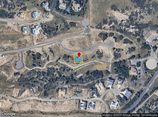
8048 Stewart Peak Pl, Castle Rock, CO 80108
NEARBY LISTINGS FOR SALE OR LEASE
Property Detail
8048 Stewart Peak Pl
Denver-Aurora-Lakewood, CO
Castle Pines Village Filing No 41
2351-161-06-034
LOT 48 CASTLE PINES 41 0.24 AM/L
Residentialacreage
Douglas
X
Colorado
08035C0180G
48
2024
0.24 AC
2024
Parker/Castle Rock
014017
Denver
DEMOGRAPHICS near 8048 Stewart Peak Pl
1 Mile
3 Mile
5 Mile
2024 Total Population
3,234
28,560
63,412
2029 Population
3,773
32,391
71,796
Pop Growth 2024-2029
+ 16.67%
+ 13.41%
+ 13.22%
Average Age
45
41
40
2024 Total Households
1,138
10,136
21,953
HH Growth 2024-2029
+ 16.52%
+ 13.55%
+ 13.33%
Median Household Inc
$235,694
$160,852
$145,999
Avg Household Size
2.80
2.80
2.80
2024 Avg HH Vehicles
3.00
2.00
2.00
Median Home Value
$911,999
$790,233
$712,756
Median Year Built
2002
2001
2004
Nearby Places
Map Layers
Map Styles
 Street
 Aerial
- Restaurants
- Banks
- Shops
- Fitness
- Groceries
Nearby Properties
Address
Land Use
TOTAL SIZE
Lot Size
Zoning
Address
Land Use
TOTAL SIZE
Lot Size
Zoning
463,911 SF
55.80 AC
Address
Land Use
TOTAL SIZE
Lot Size
Zoning
218,106 SF
35.19 AC
Address
Land Use
TOTAL SIZE
Lot Size
Zoning
389,277 SF
28.08 AC
Address
Land Use
TOTAL SIZE
Lot Size
Zoning
128,680 SF
21.86 AC
Address
Land Use
TOTAL SIZE
Lot Size
Zoning
122,581 SF
13.81 AC
Address
Land Use
TOTAL SIZE
Lot Size
Zoning
115,552 SF
14.04 AC
Address
Land Use
TOTAL SIZE
Lot Size
Zoning
392,610 SF
15.21 AC
Address
Land Use
TOTAL SIZE
Lot Size
Zoning
112,044 SF
7.85 AC
PDU
Address
Land Use
TOTAL SIZE
Lot Size
Zoning
467,796 SF
55.80 AC
Address
Land Use
TOTAL SIZE
Lot Size
Zoning
105,496 SF
10.22 AC
Address
Land Use
TOTAL SIZE
Lot Size
Zoning
335,336 SF
20.25 AC
Address
Land Use
TOTAL SIZE
Lot Size
Zoning
136,674 SF
16.43 AC
Address
Land Use
TOTAL SIZE
Lot Size
Zoning
84,000 SF
6 AC
Address
Land Use
TOTAL SIZE
Lot Size
Zoning
59,843 SF
39.95 AC
Address
Land Use
TOTAL SIZE
Lot Size
Zoning
56,868 SF
7.95 AC
Address
Land Use
TOTAL SIZE
Lot Size
Zoning
47,354 SF
14.93 AC
Address
Land Use
TOTAL SIZE
Lot Size
Zoning
345,078 SF
10.16 AC
Address
Land Use
TOTAL SIZE
Lot Size
Zoning
49,940 SF
8.48 AC
ER
Address
Land Use
TOTAL SIZE
Lot Size
Zoning
253,264 SF
12.79 AC
Address
Land Use
TOTAL SIZE
Lot Size
Zoning
254,100 SF
13.45 AC
Address
Land Use
TOTAL SIZE
Lot Size
Zoning
138,444 SF
12.54 AC
Address
Land Use
TOTAL SIZE
Lot Size
Zoning
210,495 SF
9.85 AC
Address
Land Use
TOTAL SIZE
Lot Size
Zoning
86,461 SF
8.56 AC
Address
Land Use
TOTAL SIZE
Lot Size
Zoning
209,519 SF
6.19 AC
Address
Land Use
TOTAL SIZE
Lot Size
Zoning
51,020 SF
7.33 AC
Address
Land Use
TOTAL SIZE
Lot Size
Zoning
51,668 SF
11.94 AC
Address
Land Use
TOTAL SIZE
Lot Size
Zoning
79,190 SF
8.32 AC
Address
Land Use
TOTAL SIZE
Lot Size
Zoning
39,299 SF
18.45 AC
PDU
Address
Land Use
TOTAL SIZE
Lot Size
Zoning
116,417 SF
11.82 AC
Address
Land Use
TOTAL SIZE
Lot Size
Zoning
22,917 SF
159 AC
The World's #1 Commercial Real Estate Marketplace
Connect with us
© 2025 CoStar Group
The information above has been obtained from sources believed reliable. While we do not doubt its accuracy we have not verified it and make no guarantee, warranty or representation about it. It is your responsibility to independently confirm its accuracy and completeness. Any projections, opinions, assumptions, or estimates used are for example only and do not represent the current or future performance of the property. The value of this transaction to you depends on tax and other factors which should be evaluated by your tax, financial, and legal advisors. You and your advisors should conduct a careful, independent investigation of the property to determine to your satisfaction the suitability of the property for your needs.