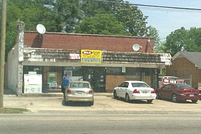
Property Record
805 Cokey Rd, Rocky Mount, NC 27801

Property Detail
805 Cokey Rd
3759-85-2841-00
805-807 COKEY RD
Commercialnec
Edgecombe
B and X Area of moderate flood hazard, usually the area between the limits of the 100-year and 500-year floods.
North Carolina
2025
0.23 AC
2025
Rocky Mount/Wilson
020200
Other Market Areas
2,725 SF
Rocky Mount, NC
NEARBY LISTINGS FOR SALE OR LEASE
DEMOGRAPHICS near 805 Cokey Rd
1 mile
3 mile
5 mile
2025 Total Population
7,913
31,113
55,541
2030 Population
8,295
32,434
57,314
Pop Growth 2025-2030
+ 4.83%
+ 4.25%
+ 3.19%
Average Age
41
41
41
2025 Total Households
3,245
13,108
23,792
HH Growth 2025-2030
+ 5.05%
+ 4.41%
+ 3.27%
Median Household Inc
$32,103
$42,025
$53,854
Avg Household Size
2.30
2.30
2.30
2025 Avg HH Vehicles
1.00
2.00
2.00
Median Home Value
$97,332
$132,350
$167,208
Median Year Built
1964
1970
1978
Nearby Places
Map Layers
Map Styles
 Street
 Aerial
Layers
 Traffic
 Biking
Places
Listings with unknown addresses are not visible on the map
- Restaurants
- Banks
- Shops
- Fitness
- Groceries
PUBLIC TRANSPORTATION
COMMUTER RAIL
Rocky Mount (Carolinian - Amtrak, Palmetto - Amtrak, Silver Meteor - Amtrak, Silver Star - Amtrak)
Drive
Walk
Distance
Rocky Mount (Carolinian - Amtrak, Palmetto - Amtrak, Silver Meteor - Amtrak, Silver Star - Amtrak)
2 min
19 min
1.0 mi
Freight Ports
Virginia Port Authority - Portsmouth
Drive
Walk
Distance
Virginia Port Authority - Portsmouth
164 min
137.7 mi
SALE & LEASE HISTORY
LISTING DATE
SALE/LEASE

Sep 04, 2025
For Lease
Nearby Properties
Address
Land Use
TOTAL SIZE
Lot Size
Zoning
Address
Land Use
TOTAL SIZE
Lot Size
Zoning
7,020 SF
33.70 AC
R6
Address
Land Use
TOTAL SIZE
Lot Size
Zoning
2,500 SF
14.61 AC
R6
Address
Land Use
TOTAL SIZE
Lot Size
Zoning
129,595 SF
11.35 AC
B2CU
Address
Land Use
TOTAL SIZE
Lot Size
Zoning
130,639 SF
60.52 AC
A1M
Address
Land Use
TOTAL SIZE
Lot Size
Zoning
10,632 SF
16.61 AC
R6
Address
Land Use
TOTAL SIZE
Lot Size
Zoning
78,052 SF
122.10 AC
I2
Address
Land Use
TOTAL SIZE
Lot Size
Zoning
165,000 SF
4.66 AC
Address
Land Use
TOTAL SIZE
Lot Size
Zoning
8,216 SF
4.21 AC
B4
Address
Land Use
TOTAL SIZE
Lot Size
Zoning
32,051 SF
18.50 AC
R6
Address
Land Use
TOTAL SIZE
Lot Size
Zoning
15,650 SF
32.25 AC
R10
Address
Land Use
TOTAL SIZE
Lot Size
Zoning
47,968 SF
4.68 AC
I
Address
Land Use
TOTAL SIZE
Lot Size
Zoning
118,800 SF
5.51 AC
I
Address
Land Use
TOTAL SIZE
Lot Size
Zoning
13,075 SF
14.90 AC
Address
Land Use
TOTAL SIZE
Lot Size
Zoning
135,400 SF
21.45 AC
B2
Address
Land Use
TOTAL SIZE
Lot Size
Zoning
129,264 SF
31.28 AC
B3
Address
Land Use
TOTAL SIZE
Lot Size
Zoning
42,449 SF
2.49 AC
I2
Address
Land Use
TOTAL SIZE
Lot Size
Zoning
61,850 SF
10 AC
I2
Address
Land Use
TOTAL SIZE
Lot Size
Zoning
140,705 SF
14.34 AC
I2
Address
Land Use
TOTAL SIZE
Lot Size
Zoning
79,481 SF
14.25 AC
R6
Address
Land Use
TOTAL SIZE
Lot Size
Zoning
26,401 SF
7.50 AC
R10
Address
Land Use
TOTAL SIZE
Lot Size
Zoning
30,481 SF
4.14 AC
Address
Land Use
TOTAL SIZE
Lot Size
Zoning
3,360 SF
6.27 AC
R10
Address
Land Use
TOTAL SIZE
Lot Size
Zoning
2,888 SF
3.35 AC
Address
Land Use
TOTAL SIZE
Lot Size
Zoning
29,187 SF
29.05 AC
R10
Address
Land Use
TOTAL SIZE
Lot Size
Zoning
60,793 SF
10.20 AC
I2
Address
Land Use
TOTAL SIZE
Lot Size
Zoning
113,921 SF
7.82 AC
B2
Address
Land Use
TOTAL SIZE
Lot Size
Zoning
69,902 SF
12.92 AC
B5
Address
Land Use
TOTAL SIZE
Lot Size
Zoning
95,646 SF
8.44 AC
B2
Address
Land Use
TOTAL SIZE
Lot Size
Zoning
52,789 SF
21.90 AC
I2
Address
Land Use
TOTAL SIZE
Lot Size
Zoning
9,892 SF
11.92 AC
R6
The World's #1 Commercial Real Estate Marketplace
Connect with us
© 2026 CoStar Group
The information above has been obtained from sources believed reliable. While we do not doubt its accuracy we have not verified it and make no guarantee, warranty or representation about it. It is your responsibility to independently confirm its accuracy and completeness. Any projections, opinions, assumptions, or estimates used are for example only and do not represent the current or future performance of the property. The value of this transaction to you depends on tax and other factors which should be evaluated by your tax, financial, and legal advisors. You and your advisors should conduct a careful, independent investigation of the property to determine to your satisfaction the suitability of the property for your needs.