Property Record
805 Cooper Rd, Voorhees, NJ 08043
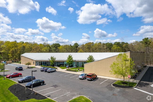


This Property Is For Sale
NEARBY LISTINGS FOR SALE OR LEASE
Property Detail
805 Cooper Rd
34-00202-23-00030
Camden
Commercialnec
New Jersey
X
30
34007C0127E
4.56 AC
2024
South Camden County
2025
Philadelphia
607502
Philadelphia-Camden-Wilmington, PA-NJ-DE-MD
23,336 SF
DEMOGRAPHICS near 805 Cooper Rd
1 Mile
3 Mile
5 Mile
2024 Total Population
8,206
68,495
199,287
2029 Population
8,114
68,587
199,804
Pop Growth 2024-2029
(1.12%)
+ 0.13%
+ 0.26%
Average Age
45
43
41
2024 Total Households
3,230
26,024
77,615
HH Growth 2024-2029
(1.18%)
+ 0.15%
+ 0.26%
Median Household Inc
$118,201
$118,099
$99,386
Avg Household Size
2.50
2.50
2.50
2024 Avg HH Vehicles
2.00
2.00
2.00
Median Home Value
$392,495
$356,038
$306,492
Median Year Built
1987
1979
1974
Nearby Places
Map Layers
Map Styles
 Street
 Aerial
- Restaurants
- Banks
- Shops
- Fitness
- Groceries
PUBLIC TRANSPORTATION
COMMUTER RAIL
Lindenwold (NJT) (Atlantic City Line - NJ Transit Commuter Rail (NJ Transit))
DRIVE
WALK
Distance
Lindenwold (NJT) (Atlantic City Line - NJ Transit Commuter Rail (NJ Transit))
10 min
4.4 mi
Atco (Atlantic City Line - NJ Transit Commuter Rail (NJ Transit))
DRIVE
WALK
Distance
Atco (Atlantic City Line - NJ Transit Commuter Rail (NJ Transit))
14 min
7.8 mi
AIRPORT
Philadelphia International
DRIVE
WALK
Distance
Philadelphia International
36 min
21.6 mi
Atlantic City International
DRIVE
WALK
Distance
Atlantic City International
72 min
39.4 mi
Trenton Mercer
DRIVE
WALK
Distance
Trenton Mercer
58 min
39.8 mi
Nearby Properties
Address
Land Use
TOTAL SIZE
Lot Size
Zoning
Address
Land Use
TOTAL SIZE
Lot Size
Zoning
58.91 AC
MB
Address
Land Use
TOTAL SIZE
Lot Size
Zoning
256,152 SF
58.91 AC
MB
Address
Land Use
TOTAL SIZE
Lot Size
Zoning
79.35 AC
CP
Address
Land Use
TOTAL SIZE
Lot Size
Zoning
1,896 SF
93.79 AC
LD
Address
Land Use
TOTAL SIZE
Lot Size
Zoning
270,246 SF
0.71 AC
RA
Address
Land Use
TOTAL SIZE
Lot Size
Zoning
16.61 AC
SH
Address
Land Use
TOTAL SIZE
Lot Size
Zoning
232,026 SF
24.41 AC
B
Address
Land Use
TOTAL SIZE
Lot Size
Zoning
44.80 AC
C-1
Address
Land Use
TOTAL SIZE
Lot Size
Zoning
5 AC
C-1
Address
Land Use
TOTAL SIZE
Lot Size
Zoning
168,264 SF
30.98 AC
TC
Address
Land Use
TOTAL SIZE
Lot Size
Zoning
258,896 SF
11.25 AC
TC
Address
Land Use
TOTAL SIZE
Lot Size
Zoning
4,177 SF
32.42 AC
SH
Address
Land Use
TOTAL SIZE
Lot Size
Zoning
244,640 SF
11.04 AC
TC
Address
Land Use
TOTAL SIZE
Lot Size
Zoning
52.30 AC
MD
Address
Land Use
TOTAL SIZE
Lot Size
Zoning
414,080 SF
15.75 AC
TC
Address
Land Use
TOTAL SIZE
Lot Size
Zoning
Address
Land Use
TOTAL SIZE
Lot Size
Zoning
114,852 SF
12.73 AC
GB2
Address
Land Use
TOTAL SIZE
Lot Size
Zoning
38.13 AC
CP
Address
Land Use
TOTAL SIZE
Lot Size
Zoning
57.50 AC
Address
Land Use
TOTAL SIZE
Lot Size
Zoning
186,464 SF
19.93 AC
MB
Address
Land Use
TOTAL SIZE
Lot Size
Zoning
147,136 SF
9.55 AC
TC
Address
Land Use
TOTAL SIZE
Lot Size
Zoning
185,936 SF
11.30 AC
TC
Address
Land Use
TOTAL SIZE
Lot Size
Zoning
Address
Land Use
TOTAL SIZE
Lot Size
Zoning
40,116 SF
2.84 AC
TC
Address
Land Use
TOTAL SIZE
Lot Size
Zoning
122,264 SF
5 AC
RR
Address
Land Use
TOTAL SIZE
Lot Size
Zoning
58,330 SF
5.08 AC
MB
Address
Land Use
TOTAL SIZE
Lot Size
Zoning
90,080 SF
5.22 AC
MB
Address
Land Use
TOTAL SIZE
Lot Size
Zoning
42.80 AC
MF
Address
Land Use
TOTAL SIZE
Lot Size
Zoning
11.29 AC
Address
Land Use
TOTAL SIZE
Lot Size
Zoning
25.28 AC
C-1
The World's #1 Commercial Real Estate Marketplace
Connect with us
© 2026 CoStar Group
The information above has been obtained from sources believed reliable. While we do not doubt its accuracy we have not verified it and make no guarantee, warranty or representation about it. It is your responsibility to independently confirm its accuracy and completeness. Any projections, opinions, assumptions, or estimates used are for example only and do not represent the current or future performance of the property. The value of this transaction to you depends on tax and other factors which should be evaluated by your tax, financial, and legal advisors. You and your advisors should conduct a careful, independent investigation of the property to determine to your satisfaction the suitability of the property for your needs.