Property Record
805 Florala Hwy, Opp, AL 36467
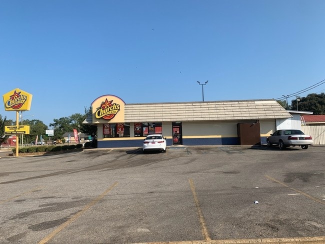


Property Detail
805 Florala Hwy
11-08-33-1-001-017.003
DB/PG>2021/14905 1/29/2021 BEG @ SE COR LOT 1 BLK D BENTON SUB TO OPP PB 2 PG 94 S33 T4N R18E TH E-80' TO E R/W US HWY 331; N
Restaurantbuilding
COVINGTON
B and X Area of moderate flood hazard, usually the area between the limits of the 100-year and 500-year floods.
Alabama
2025
1
2025
0.60 AC
962700
Alabama South Area
1,471 SF
Other Market Areas
NEARBY LISTINGS FOR SALE OR LEASE
-
-
View all Opp listings for sale on LoopNet.com
DEMOGRAPHICS near 805 Florala Hwy
1 mile
3 mile
5 mile
2025 Total Population
2,182
6,636
8,384
2030 Population
2,149
6,564
8,305
Pop Growth 2025-2030
(1.51%)
(1.08%)
(0.94%)
Average Age
41
42
43
2025 Total Households
874
2,671
3,389
HH Growth 2025-2030
(1.60%)
(1.12%)
(1.03%)
Median Household Inc
$41,235
$43,340
$43,617
Avg Household Size
2.30
2.30
2.30
2025 Avg HH Vehicles
2.00
2.00
2.00
Median Home Value
$144,898
$139,984
$140,216
Median Year Built
1968
1972
1974
Nearby Places
Map Layers
Map Styles
 Street
 Aerial
Layers
 Traffic
 Biking
Places
Listings with unknown addresses are not visible on the map
- Restaurants
- Banks
- Shops
- Fitness
- Groceries
SALE & LEASE HISTORY
LISTING DATE
SALE/LEASE

Oct 31, 2019
For Sale
Nearby Properties
Address
Land Use
TOTAL SIZE
Lot Size
Zoning
Address
Land Use
TOTAL SIZE
Lot Size
Zoning
65,194 SF
6 AC
Address
Land Use
TOTAL SIZE
Lot Size
Zoning
6,860 SF
5 AC
Address
Land Use
TOTAL SIZE
Lot Size
Zoning
3,600 SF
13 AC
Address
Land Use
TOTAL SIZE
Lot Size
Zoning
23,392 SF
3 AC
Address
Land Use
TOTAL SIZE
Lot Size
Zoning
15,018 SF
0.70 AC
Address
Land Use
TOTAL SIZE
Lot Size
Zoning
25,480 SF
1 AC
Address
Land Use
TOTAL SIZE
Lot Size
Zoning
14,107 SF
4 AC
Address
Land Use
TOTAL SIZE
Lot Size
Zoning
52,622 SF
7.80 AC
Address
Land Use
TOTAL SIZE
Lot Size
Zoning
8,220 SF
1.16 AC
Address
Land Use
TOTAL SIZE
Lot Size
Zoning
58,600 SF
4.80 AC
Address
Land Use
TOTAL SIZE
Lot Size
Zoning
5,934 SF
1.70 AC
Address
Land Use
TOTAL SIZE
Lot Size
Zoning
1,932 SF
1.48 AC
Address
Land Use
TOTAL SIZE
Lot Size
Zoning
2,304 SF
2.37 AC
Address
Land Use
TOTAL SIZE
Lot Size
Zoning
28,685 SF
Address
Land Use
TOTAL SIZE
Lot Size
Zoning
9,292 SF
4.20 AC
Address
Land Use
TOTAL SIZE
Lot Size
Zoning
17,300 SF
1.28 AC
Address
Land Use
TOTAL SIZE
Lot Size
Zoning
6,832 SF
3.10 AC
Address
Land Use
TOTAL SIZE
Lot Size
Zoning
5,839 SF
3.53 AC
Address
Land Use
TOTAL SIZE
Lot Size
Zoning
31,592 SF
2.92 AC
Address
Land Use
TOTAL SIZE
Lot Size
Zoning
8,928 SF
0.17 AC
Address
Land Use
TOTAL SIZE
Lot Size
Zoning
39 AC
Address
Land Use
TOTAL SIZE
Lot Size
Zoning
9,304 SF
1.98 AC
Address
Land Use
TOTAL SIZE
Lot Size
Zoning
4,187 SF
2.41 AC
Address
Land Use
TOTAL SIZE
Lot Size
Zoning
6,840 SF
2.50 AC
Address
Land Use
TOTAL SIZE
Lot Size
Zoning
17,196 SF
1.86 AC
Address
Land Use
TOTAL SIZE
Lot Size
Zoning
44,000 SF
9.60 AC
The World's #1 Commercial Real Estate Marketplace
Connect with us
© 2026 CoStar Group
The information above has been obtained from sources believed reliable. While we do not doubt its accuracy we have not verified it and make no guarantee, warranty or representation about it. It is your responsibility to independently confirm its accuracy and completeness. Any projections, opinions, assumptions, or estimates used are for example only and do not represent the current or future performance of the property. The value of this transaction to you depends on tax and other factors which should be evaluated by your tax, financial, and legal advisors. You and your advisors should conduct a careful, independent investigation of the property to determine to your satisfaction the suitability of the property for your needs.