Property Record
805 Farson St, Belpre, OH 45714
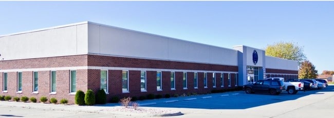

Property Detail
805 Farson St
Marietta, OH
R10 T2 S2 38.86 AC LOT 30 S PT N OF RR 1.683 AC
0800-30508-002
Washington
Medicalbuilding
Ohio
B and X Area of moderate flood hazard, usually the area between the limits of the 100-year and 500-year floods.
30
2025
1.68 AC
2025
Ohio South Area
020101
Other Market Areas
24,000 SF
NEARBY LISTINGS FOR SALE OR LEASE
DEMOGRAPHICS near 805 Farson St
1 mile
3 mile
5 mile
2025 Total Population
1,774
12,549
49,098
2030 Population
1,713
12,279
48,434
Pop Growth 2025-2030
(3.44%)
(2.15%)
(1.35%)
Average Age
45
43
43
2025 Total Households
826
5,562
21,638
HH Growth 2025-2030
(3.51%)
(2.23%)
(1.44%)
Median Household Inc
$49,694
$58,372
$51,288
Avg Household Size
2.10
2.20
2.20
2025 Avg HH Vehicles
2.00
2.00
2.00
Median Home Value
$157,089
$170,612
$152,651
Median Year Built
1969
1972
1963
Nearby Places
Map Layers
Map Styles
 Street
 Aerial
Layers
 Traffic
 Biking
Places
Listings with unknown addresses are not visible on the map
- Restaurants
- Banks
- Shops
- Fitness
- Groceries
Nearby Properties
Address
Land Use
TOTAL SIZE
Lot Size
Zoning
Address
Land Use
TOTAL SIZE
Lot Size
Zoning
40,548 SF
1.23 AC
Address
Land Use
TOTAL SIZE
Lot Size
Zoning
64.43 AC
Address
Land Use
TOTAL SIZE
Lot Size
Zoning
Address
Land Use
TOTAL SIZE
Lot Size
Zoning
24,645 SF
1.38 AC
Address
Land Use
TOTAL SIZE
Lot Size
Zoning
46,710 SF
3.26 AC
Address
Land Use
TOTAL SIZE
Lot Size
Zoning
17,286 SF
1.79 AC
Address
Land Use
TOTAL SIZE
Lot Size
Zoning
8.40 AC
Address
Land Use
TOTAL SIZE
Lot Size
Zoning
24,800 SF
1.51 AC
Address
Land Use
TOTAL SIZE
Lot Size
Zoning
42,169 SF
4 AC
Address
Land Use
TOTAL SIZE
Lot Size
Zoning
6.96 AC
Address
Land Use
TOTAL SIZE
Lot Size
Zoning
26,250 SF
12.32 AC
Address
Land Use
TOTAL SIZE
Lot Size
Zoning
1.34 AC
Address
Land Use
TOTAL SIZE
Lot Size
Zoning
12,662 SF
1.14 AC
Address
Land Use
TOTAL SIZE
Lot Size
Zoning
9.23 AC
Address
Land Use
TOTAL SIZE
Lot Size
Zoning
58,458 SF
4.67 AC
Address
Land Use
TOTAL SIZE
Lot Size
Zoning
1,518 SF
5 AC
Address
Land Use
TOTAL SIZE
Lot Size
Zoning
21,726 SF
3.39 AC
Address
Land Use
TOTAL SIZE
Lot Size
Zoning
63,712 SF
8.10 AC
Address
Land Use
TOTAL SIZE
Lot Size
Zoning
2.04 AC
Address
Land Use
TOTAL SIZE
Lot Size
Zoning
2.97 AC
Address
Land Use
TOTAL SIZE
Lot Size
Zoning
10.29 AC
Address
Land Use
TOTAL SIZE
Lot Size
Zoning
0.22 AC
Address
Land Use
TOTAL SIZE
Lot Size
Zoning
27.21 AC
Address
Land Use
TOTAL SIZE
Lot Size
Zoning
37,652 SF
0.92 AC
Address
Land Use
TOTAL SIZE
Lot Size
Zoning
7.59 AC
Address
Land Use
TOTAL SIZE
Lot Size
Zoning
41,610 SF
5.83 AC
Address
Land Use
TOTAL SIZE
Lot Size
Zoning
Address
Land Use
TOTAL SIZE
Lot Size
Zoning
2.34 AC
Address
Land Use
TOTAL SIZE
Lot Size
Zoning
1,056 SF
3.56 AC
The World's #1 Commercial Real Estate Marketplace
Connect with us
© 2026 CoStar Group
The information above has been obtained from sources believed reliable. While we do not doubt its accuracy we have not verified it and make no guarantee, warranty or representation about it. It is your responsibility to independently confirm its accuracy and completeness. Any projections, opinions, assumptions, or estimates used are for example only and do not represent the current or future performance of the property. The value of this transaction to you depends on tax and other factors which should be evaluated by your tax, financial, and legal advisors. You and your advisors should conduct a careful, independent investigation of the property to determine to your satisfaction the suitability of the property for your needs.