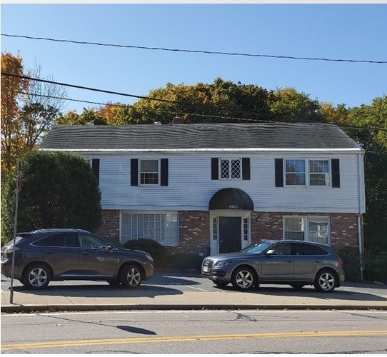
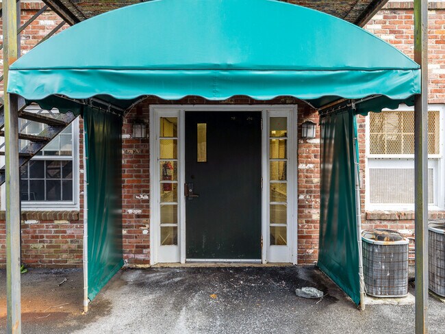
Property Record
805 High St, Westwood, MA 02090

Current Lease Availabilities
NEARBY LISTINGS FOR SALE OR LEASE
Property Detail
805 High St
WWOO-000014-000000-000142
Norfolk
Officebuilding
Massachusetts
X
142
25021C0176F
0.37 AC
2025
Route 1 South
2025
Boston
412100
Boston-Cambridge-Newton, MA-NH
4,148 SF
DEMOGRAPHICS near 805 High St
1 Mile
3 Mile
5 Mile
2024 Total Population
5,101
42,558
137,050
2029 Population
5,114
42,374
135,576
Pop Growth 2024-2029
+ 0.25%
(0.43%)
(1.08%)
Average Age
43
43
42
2024 Total Households
1,846
16,198
51,111
HH Growth 2024-2029
+ 0.22%
(0.58%)
(1.24%)
Median Household Inc
$158,513
$124,328
$132,334
Avg Household Size
2.70
2.50
2.60
2024 Avg HH Vehicles
2.00
2.00
2.00
Median Home Value
$850,054
$758,375
$751,269
Median Year Built
1959
1962
1961
Nearby Places
Map Layers
Map Styles
 Street
 Aerial
- Restaurants
- Banks
- Shops
- Fitness
- Groceries
PUBLIC TRANSPORTATION
COMMUTER RAIL
Norwood Depot (Franklin Line - Massachusetts Bay Transportation Authority Commuter Rail (Purple Line))
DRIVE
WALK
Distance
Norwood Depot (Franklin Line - Massachusetts Bay Transportation Authority Commuter Rail (Purple Line))
6 min
2.6 mi
Norwood Central (Franklin Line - Massachusetts Bay Transportation Authority Commuter Rail (Purple Line))
DRIVE
WALK
Distance
Norwood Central (Franklin Line - Massachusetts Bay Transportation Authority Commuter Rail (Purple Line))
7 min
2.9 mi
AIRPORT
General Edward Lawrence Logan International
DRIVE
WALK
Distance
General Edward Lawrence Logan International
35 min
18.5 mi
Worcester Regional
DRIVE
WALK
Distance
Worcester Regional
70 min
48.4 mi
Freight Ports
Port of Boston
DRIVE
WALK
Distance
Port of Boston
34 min
16.9 mi
Nearby Properties
Address
Land Use
TOTAL SIZE
Lot Size
Zoning
Address
Land Use
TOTAL SIZE
Lot Size
Zoning
380,030 SF
24.87 AC
Address
Land Use
TOTAL SIZE
Lot Size
Zoning
413,827 SF
9.49 AC
RDO
Address
Land Use
TOTAL SIZE
Lot Size
Zoning
11.66 AC
LM
Address
Land Use
TOTAL SIZE
Lot Size
Zoning
380,030 SF
24.87 AC
Address
Land Use
TOTAL SIZE
Lot Size
Zoning
45,836 SF
23.25 AC
Address
Land Use
TOTAL SIZE
Lot Size
Zoning
221,803 SF
36.46 AC
Address
Land Use
TOTAL SIZE
Lot Size
Zoning
5,349 SF
8.74 AC
Address
Land Use
TOTAL SIZE
Lot Size
Zoning
132,917 SF
24 AC
RE
Address
Land Use
TOTAL SIZE
Lot Size
Zoning
45.72 AC
LM
Address
Land Use
TOTAL SIZE
Lot Size
Zoning
15 AC
Address
Land Use
TOTAL SIZE
Lot Size
Zoning
141,322 SF
36.84 AC
Address
Land Use
TOTAL SIZE
Lot Size
Zoning
242,198 SF
53.28 AC
Address
Land Use
TOTAL SIZE
Lot Size
Zoning
294,771 SF
17.85 AC
Address
Land Use
TOTAL SIZE
Lot Size
Zoning
130,344 SF
8.18 AC
Address
Land Use
TOTAL SIZE
Lot Size
Zoning
18.01 AC
GB
Address
Land Use
TOTAL SIZE
Lot Size
Zoning
150,802 SF
3.09 AC
LM
Address
Land Use
TOTAL SIZE
Lot Size
Zoning
15.40 AC
LM
Address
Land Use
TOTAL SIZE
Lot Size
Zoning
170,482 SF
18.60 AC
Address
Land Use
TOTAL SIZE
Lot Size
Zoning
218,676 SF
22.54 AC
Address
Land Use
TOTAL SIZE
Lot Size
Zoning
11.70 AC
Address
Land Use
TOTAL SIZE
Lot Size
Zoning
92,278 SF
10.58 AC
Address
Land Use
TOTAL SIZE
Lot Size
Zoning
361,239 SF
37.28 AC
Address
Land Use
TOTAL SIZE
Lot Size
Zoning
529.60 AC
R2
Address
Land Use
TOTAL SIZE
Lot Size
Zoning
33,778 SF
18.86 AC
Address
Land Use
TOTAL SIZE
Lot Size
Zoning
314.70 AC
R2
Address
Land Use
TOTAL SIZE
Lot Size
Zoning
27.61 AC
Address
Land Use
TOTAL SIZE
Lot Size
Zoning
138,380 SF
17.26 AC
Address
Land Use
TOTAL SIZE
Lot Size
Zoning
54,792 SF
30.05 AC
Address
Land Use
TOTAL SIZE
Lot Size
Zoning
29,094 SF
9.03 AC
Address
Land Use
TOTAL SIZE
Lot Size
Zoning
52,716 SF
12.28 AC
The World's #1 Commercial Real Estate Marketplace
Connect with us
© 2025 CoStar Group
The information above has been obtained from sources believed reliable. While we do not doubt its accuracy we have not verified it and make no guarantee, warranty or representation about it. It is your responsibility to independently confirm its accuracy and completeness. Any projections, opinions, assumptions, or estimates used are for example only and do not represent the current or future performance of the property. The value of this transaction to you depends on tax and other factors which should be evaluated by your tax, financial, and legal advisors. You and your advisors should conduct a careful, independent investigation of the property to determine to your satisfaction the suitability of the property for your needs.