Property Record
805 N Federal Hwy, Boynton Beach, FL 33435
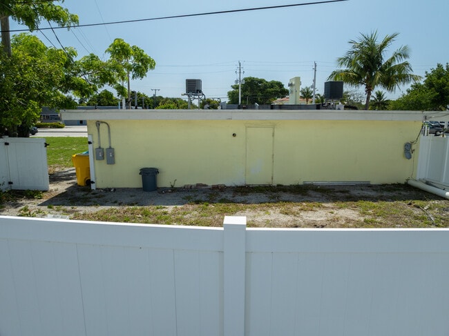
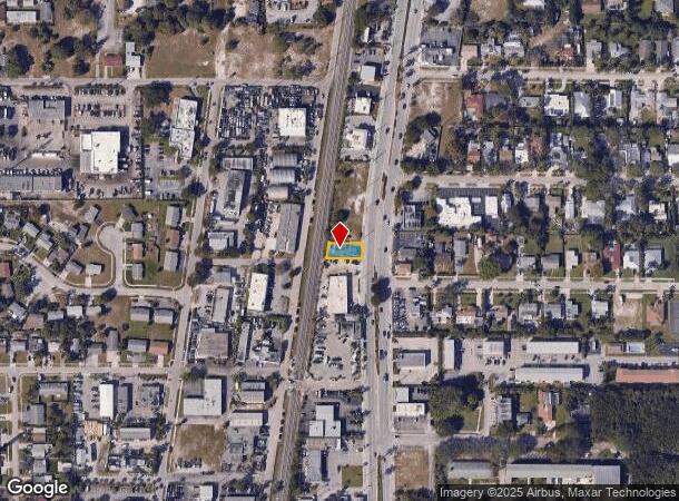
This Property Is For Sale
NEARBY LISTINGS FOR SALE OR LEASE
Property Detail
805 N Federal Hwy
West Palm Beach-Boca Raton-Delray Beach, FL
Lake Add To Boynton
08-43-45-21-32-001-0170
LAKE ADD TO BOYNTON LT 17 (LESS ELY 17 FT N FED HWY R/W) BLK 1 & 20 FT ABND PT OF ALLEY LYG W OF & ADJ TO
Storemultistory
Palm Beach
X
Florida
12099C0791F
17
2024
0.13 AC
2024
Boynton/Lantana
006100
South Florida
1,796 SF
DEMOGRAPHICS near 805 N Federal Hwy
1 Mile
3 Mile
5 Mile
2024 Total Population
16,100
91,686
201,465
2029 Population
16,939
95,723
210,422
Pop Growth 2024-2029
+ 5.21%
+ 4.40%
+ 4.45%
Average Age
43
44
45
2024 Total Households
6,403
39,167
85,641
HH Growth 2024-2029
+ 5.37%
+ 4.42%
+ 4.49%
Median Household Inc
$56,695
$62,810
$67,161
Avg Household Size
2.30
2.20
2.20
2024 Avg HH Vehicles
2.00
2.00
2.00
Median Home Value
$348,097
$270,001
$309,593
Median Year Built
1976
1983
1984
Nearby Places
- Restaurants
- Banks
- Shops
- Fitness
- Groceries
PUBLIC TRANSPORTATION
COMMUTER RAIL
Boynton Beach (Mangonia Park - Miami Airport - Tri-Rail, Tri-County Commuter - Tri-Rail)
DRIVE
WALK
Distance
Boynton Beach (Mangonia Park - Miami Airport - Tri-Rail, Tri-County Commuter - Tri-Rail)
7 min
2.8 mi
Lake Worth (Mangonia Park - Miami Airport - Tri-Rail, Tri-County Commuter - Tri-Rail)
DRIVE
WALK
Distance
Lake Worth (Mangonia Park - Miami Airport - Tri-Rail, Tri-County Commuter - Tri-Rail)
13 min
7.7 mi
AIRPORT
Palm Beach International
DRIVE
WALK
Distance
Palm Beach International
21 min
14.4 mi
Freight Ports
Port of Palm Beach
DRIVE
WALK
Distance
Port of Palm Beach
31 min
19.7 mi
Nearby Properties
Address
Land Use
TOTAL SIZE
Lot Size
Zoning
Address
Land Use
TOTAL SIZE
Lot Size
Zoning
822,044 SF
11.62 AC
MU-4
Address
Land Use
TOTAL SIZE
Lot Size
Zoning
980,025 SF
22.78 AC
PU
Address
Land Use
TOTAL SIZE
Lot Size
Zoning
514,687 SF
19.38 AC
SMU
Address
Land Use
TOTAL SIZE
Lot Size
Zoning
437,883 SF
3.69 AC
MU-4
Address
Land Use
TOTAL SIZE
Lot Size
Zoning
525,037 SF
25.65 AC
PUD
Address
Land Use
TOTAL SIZE
Lot Size
Zoning
391,475 SF
13.19 AC
SMU
Address
Land Use
TOTAL SIZE
Lot Size
Zoning
527,411 SF
15.60 AC
PUD
Address
Land Use
TOTAL SIZE
Lot Size
Zoning
441,081 SF
20.08 AC
PUD
Address
Land Use
TOTAL SIZE
Lot Size
Zoning
579,116 SF
4.52 AC
MU-C
Address
Land Use
TOTAL SIZE
Lot Size
Zoning
440,818 SF
47.57 AC
RS
Address
Land Use
TOTAL SIZE
Lot Size
Zoning
403,863 SF
24.14 AC
PUD
Address
Land Use
TOTAL SIZE
Lot Size
Zoning
327,864 SF
9.21 AC
MW
Address
Land Use
TOTAL SIZE
Lot Size
Zoning
340,811 SF
49.49 AC
PID
Address
Land Use
TOTAL SIZE
Lot Size
Zoning
259,857 SF
14.18 AC
PUD
Address
Land Use
TOTAL SIZE
Lot Size
Zoning
437,380 SF
18.05 AC
PID
Address
Land Use
TOTAL SIZE
Lot Size
Zoning
303,078 SF
19.62 AC
PUD
Address
Land Use
TOTAL SIZE
Lot Size
Zoning
346,777 SF
15.91 AC
PUD
Address
Land Use
TOTAL SIZE
Lot Size
Zoning
381,807 SF
3.98 AC
SMU
Address
Land Use
TOTAL SIZE
Lot Size
Zoning
487,842 SF
63.78 AC
PID
Address
Land Use
TOTAL SIZE
Lot Size
Zoning
334,014 SF
3.35 AC
SMU
Address
Land Use
TOTAL SIZE
Lot Size
Zoning
278,460 SF
21.24 AC
PUD
Address
Land Use
TOTAL SIZE
Lot Size
Zoning
285,837 SF
14.86 AC
PUD
Address
Land Use
TOTAL SIZE
Lot Size
Zoning
214,095 SF
7.67 AC
PUD
Address
Land Use
TOTAL SIZE
Lot Size
Zoning
211,944 SF
22.76 AC
PCD
Address
Land Use
TOTAL SIZE
Lot Size
Zoning
181,150 SF
4.27 AC
SMU
Address
Land Use
TOTAL SIZE
Lot Size
Zoning
182,859 SF
4.89 AC
SMU
Address
Land Use
TOTAL SIZE
Lot Size
Zoning
240,786 SF
10.63 AC
C3
Address
Land Use
TOTAL SIZE
Lot Size
Zoning
188,621 SF
7.42 AC
PUD
Address
Land Use
TOTAL SIZE
Lot Size
Zoning
291,589 SF
11.63 AC
PID
Address
Land Use
TOTAL SIZE
Lot Size
Zoning
263,799 SF
8.36 AC
PUD
The World's #1 Commercial Real Estate Marketplace
Connect with us
© 2025 CoStar Group
The information above has been obtained from sources believed reliable. While we do not doubt its accuracy we have not verified it and make no guarantee, warranty or representation about it. It is your responsibility to independently confirm its accuracy and completeness. Any projections, opinions, assumptions, or estimates used are for example only and do not represent the current or future performance of the property. The value of this transaction to you depends on tax and other factors which should be evaluated by your tax, financial, and legal advisors. You and your advisors should conduct a careful, independent investigation of the property to determine to your satisfaction the suitability of the property for your needs.