Property Record
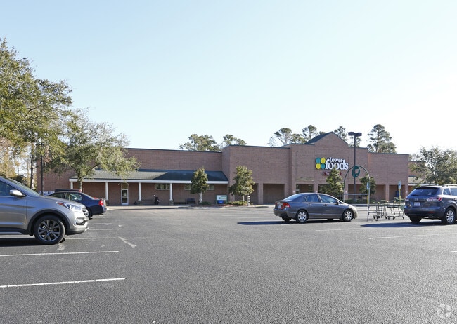
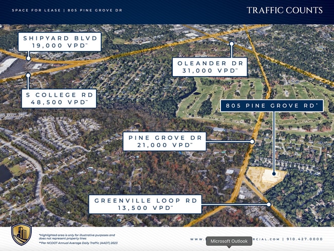
805 Pine Grove Dr, Wilmington, NC 28409

Current Lease Availabilities
Property Detail
805 Pine Grove Dr
R06116-003-002-002
PT 805 PINE GROVE DRIVE DIV
Supermarket
New Hanover
CB,COMMUNI
North Carolina
B and X Area of moderate flood hazard, usually the area between the limits of the 100-year and 500-year floods.
2
2025
4.79 AC
2025
Midtown
012011
Wilmington
46,209 SF
Wilmington, NC
NEARBY LISTINGS FOR SALE OR LEASE
DEMOGRAPHICS near 805 Pine Grove Dr
1 mile
3 mile
5 mile
2025 Total Population
6,145
62,426
145,589
2030 Population
6,468
65,367
153,860
Pop Growth 2025-2030
+ 5.26%
+ 4.71%
+ 5.68%
Average Age
41
38
40
2025 Total Households
2,559
26,240
64,403
HH Growth 2025-2030
+ 5.35%
+ 5.01%
+ 5.93%
Median Household Inc
$83,021
$73,298
$73,218
Avg Household Size
2.30
2.10
2.10
2025 Avg HH Vehicles
2.00
2.00
2.00
Median Home Value
$392,541
$392,975
$385,566
Median Year Built
1987
1990
1989
Nearby Places
Map Layers
Map Styles
 Street
 Aerial
Transit
 Traffic
 Biking
Places
Listings with unknown addresses are not visible on the map
- Restaurants
- Banks
- Shops
- Fitness
- Groceries
PUBLIC TRANSPORTATION
AIRPORT
Wilmington International
Drive
Walk
Distance
Wilmington International
23 min
10.7 mi
Freight Ports
Port of Wilmington
Drive
Walk
Distance
Port of Wilmington
13 min
6.0 mi
Nearby Properties
Address
Land Use
TOTAL SIZE
Lot Size
Zoning
Address
Land Use
TOTAL SIZE
Lot Size
Zoning
18,848 SF
649.08 AC
O&I,OFFICE
Address
Land Use
TOTAL SIZE
Lot Size
Zoning
393,150 SF
60.45 AC
O&I,OFFICE
Address
Land Use
TOTAL SIZE
Lot Size
Zoning
13,398 SF
15.67 AC
O&I,OFFICE
Address
Land Use
TOTAL SIZE
Lot Size
Zoning
35,600 SF
14.86 AC
CB,COMMUNI
Address
Land Use
TOTAL SIZE
Lot Size
Zoning
35,334 SF
38.86 AC
O&I,OFFICE
Address
Land Use
TOTAL SIZE
Lot Size
Zoning
5,563 SF
13.60 AC
MD-17
Address
Land Use
TOTAL SIZE
Lot Size
Zoning
606,792 SF
44.13 AC
RB,REGIONA
Address
Land Use
TOTAL SIZE
Lot Size
Zoning
191,720 SF
7.82 AC
RB,REGIONA
Address
Land Use
TOTAL SIZE
Lot Size
Zoning
142,207 SF
9.29 AC
O&I,OFFICE
Address
Land Use
TOTAL SIZE
Lot Size
Zoning
160,284 SF
59.79 AC
O&I,OFFICE
Address
Land Use
TOTAL SIZE
Lot Size
Zoning
150,588 SF
30.57 AC
RB,REGIONA
Address
Land Use
TOTAL SIZE
Lot Size
Zoning
128,015 SF
6.91 AC
RB,REGIONA
Address
Land Use
TOTAL SIZE
Lot Size
Zoning
153,764 SF
22.87 AC
RB,REGIONA
Address
Land Use
TOTAL SIZE
Lot Size
Zoning
108.30 AC
R-15,RESID
Address
Land Use
TOTAL SIZE
Lot Size
Zoning
6,780 SF
24.11 AC
RB,REGIONA
Address
Land Use
TOTAL SIZE
Lot Size
Zoning
228,521 SF
25.17 AC
RB,REGIONA
Address
Land Use
TOTAL SIZE
Lot Size
Zoning
24,966 SF
5.55 AC
O&I,OFFICE
Address
Land Use
TOTAL SIZE
Lot Size
Zoning
39,866 SF
15.89 AC
R-15,RESID
Address
Land Use
TOTAL SIZE
Lot Size
Zoning
1,656 SF
74.28 AC
R-15,RESID
Address
Land Use
TOTAL SIZE
Lot Size
Zoning
3,190 SF
59.66 AC
R-15,RESID
Address
Land Use
TOTAL SIZE
Lot Size
Zoning
162,023 SF
17.56 AC
RB,REGIONA
Address
Land Use
TOTAL SIZE
Lot Size
Zoning
1,560 SF
4.20 AC
CB,COMMUNI
Address
Land Use
TOTAL SIZE
Lot Size
Zoning
4,674 SF
55.08 AC
MX
Address
Land Use
TOTAL SIZE
Lot Size
Zoning
40,810 SF
20.75 AC
O&I,OFFICE
Address
Land Use
TOTAL SIZE
Lot Size
Zoning
16,922 SF
4.96 AC
RB,REGIONA
Address
Land Use
TOTAL SIZE
Lot Size
Zoning
55,917 SF
9.75 AC
RB,REGIONA
Address
Land Use
TOTAL SIZE
Lot Size
Zoning
67,668 SF
2.61 AC
RB,REGIONA
Address
Land Use
TOTAL SIZE
Lot Size
Zoning
54,529 SF
15.25 AC
RB,REGIONA
Address
Land Use
TOTAL SIZE
Lot Size
Zoning
223,059 SF
19.88 AC
RB,REGIONA
Address
Land Use
TOTAL SIZE
Lot Size
Zoning
84,162 SF
5.05 AC
O&I,OFFICE
The World's #1 Commercial Real Estate Marketplace
Connect with us
© 2026 CoStar Group
The information above has been obtained from sources believed reliable. While we do not doubt its accuracy we have not verified it and make no guarantee, warranty or representation about it. It is your responsibility to independently confirm its accuracy and completeness. Any projections, opinions, assumptions, or estimates used are for example only and do not represent the current or future performance of the property. The value of this transaction to you depends on tax and other factors which should be evaluated by your tax, financial, and legal advisors. You and your advisors should conduct a careful, independent investigation of the property to determine to your satisfaction the suitability of the property for your needs.