Property Record
8051 N Ih 35, Georgetown, TX 78633
Property Detail
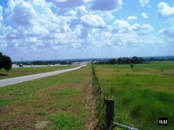
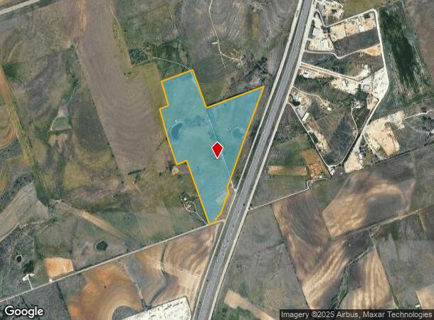
8051 N Ih 35
Austin-Round Rock-San Marcos, TX
AW0421 AW0421 - MANCHACA, A. SUR., ACRES 66.642, UNDIVIDED INTEREST
R012399
WILLIAMSON
Agriculturalland
Texas
B and X Area of moderate flood hazard, usually the area between the limits of the 100-year and 500-year floods.
66.64 AC
2024
Georgetown
2025
Austin
020119
NEARBY LISTINGS FOR SALE OR LEASE
DEMOGRAPHICS near 8051 N Ih 35
1 mile
3 mile
5 mile
2024 Total Population
32
3,095
26,187
2029 Population
37
3,639
30,614
Pop Growth 2024-2029
+ 15.63%
+ 17.58%
+ 16.91%
Average Age
38
39
41
2024 Total Households
11
1,053
9,732
HH Growth 2024-2029
+ 18.18%
+ 18.14%
+ 17.09%
Median Household Inc
$55,000
$98,332
$98,626
Avg Household Size
2.70
2.90
2.70
2024 Avg HH Vehicles
3.00
3.00
2.00
Median Home Value
$450,000
$462,257
$392,476
Median Year Built
2002
2005
2010
Nearby Places
Map Layers
Map Styles
 Street
 Aerial
Transit
 Traffic
 Biking
Places
Listings with unknown addresses are not visible on the map
- Restaurants
- Banks
- Shops
- Fitness
- Groceries
PUBLIC TRANSPORTATION
AIRPORT
Killeen Municipal
Drive
Walk
Distance
Killeen Municipal
48 min
35.1 mi
Robert Gray AAF
Drive
Walk
Distance
Robert Gray AAF
55 min
39.0 mi
Freight Ports
Port of Houston
Drive
Walk
Distance
Port of Houston
221 min
189.5 mi
Nearby Properties
Address
Land Use
TOTAL SIZE
Lot Size
Zoning
Address
Land Use
TOTAL SIZE
Lot Size
Zoning
495,945 SF
56.14 AC
Address
Land Use
TOTAL SIZE
Lot Size
Zoning
65,904 SF
14.96 AC
Address
Land Use
TOTAL SIZE
Lot Size
Zoning
101,484 SF
17.37 AC
Address
Land Use
TOTAL SIZE
Lot Size
Zoning
62,452 SF
11 AC
Address
Land Use
TOTAL SIZE
Lot Size
Zoning
39,020 SF
11.65 AC
Address
Land Use
TOTAL SIZE
Lot Size
Zoning
31,480 SF
19.73 AC
Address
Land Use
TOTAL SIZE
Lot Size
Zoning
34,278 SF
4.98 AC
Address
Land Use
TOTAL SIZE
Lot Size
Zoning
1,453 SF
360.07 AC
Address
Land Use
TOTAL SIZE
Lot Size
Zoning
28,704 SF
13.05 AC
Address
Land Use
TOTAL SIZE
Lot Size
Zoning
56,950 SF
10 AC
Address
Land Use
TOTAL SIZE
Lot Size
Zoning
14,652 SF
18.54 AC
Address
Land Use
TOTAL SIZE
Lot Size
Zoning
18,001 SF
8.87 AC
Address
Land Use
TOTAL SIZE
Lot Size
Zoning
32,935 SF
10 AC
Address
Land Use
TOTAL SIZE
Lot Size
Zoning
11,100 SF
10 AC
Address
Land Use
TOTAL SIZE
Lot Size
Zoning
2,096 SF
5 AC
Address
Land Use
TOTAL SIZE
Lot Size
Zoning
89 SF
21.40 AC
Address
Land Use
TOTAL SIZE
Lot Size
Zoning
12,218 SF
9.92 AC
Address
Land Use
TOTAL SIZE
Lot Size
Zoning
41,844 SF
107.05 AC
Address
Land Use
TOTAL SIZE
Lot Size
Zoning
32,000 SF
4.67 AC
Address
Land Use
TOTAL SIZE
Lot Size
Zoning
10,612 SF
3.59 AC
Address
Land Use
TOTAL SIZE
Lot Size
Zoning
14,615 SF
2.62 AC
Address
Land Use
TOTAL SIZE
Lot Size
Zoning
16,089 SF
228.71 AC
Address
Land Use
TOTAL SIZE
Lot Size
Zoning
78.57 AC
Address
Land Use
TOTAL SIZE
Lot Size
Zoning
3,760 SF
4.96 AC
Address
Land Use
TOTAL SIZE
Lot Size
Zoning
10,150 SF
5 AC
Address
Land Use
TOTAL SIZE
Lot Size
Zoning
86.46 AC
Address
Land Use
TOTAL SIZE
Lot Size
Zoning
16,540 SF
35.01 AC
Address
Land Use
TOTAL SIZE
Lot Size
Zoning
Address
Land Use
TOTAL SIZE
Lot Size
Zoning
6,000 SF
4.34 AC
Address
Land Use
TOTAL SIZE
Lot Size
Zoning
10,001 SF
6.79 AC
The World's #1 Commercial Real Estate Marketplace
Connect with us
© 2026 CoStar Group
The information above has been obtained from sources believed reliable. While we do not doubt its accuracy we have not verified it and make no guarantee, warranty or representation about it. It is your responsibility to independently confirm its accuracy and completeness. Any projections, opinions, assumptions, or estimates used are for example only and do not represent the current or future performance of the property. The value of this transaction to you depends on tax and other factors which should be evaluated by your tax, financial, and legal advisors. You and your advisors should conduct a careful, independent investigation of the property to determine to your satisfaction the suitability of the property for your needs.