Property Record
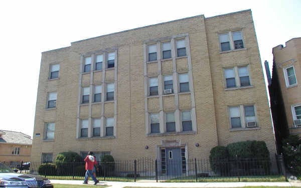
8056 S Drexel Ave, Chicago, IL 60619


This Property Is For Sale
NEARBY LISTINGS FOR SALE OR LEASE
Property Detail
8056 S Drexel Ave
Chicago-Naperville-Elgin, IL-IN-WI
Britigans Westfield
20-31-212-035-0000
(BRITIGANS)(WESTFIELD) SUB IN NE SEC 31-38-14
Apartment
Cook
X
Illinois
17031C0635J
411,4
2023
0.17 AC
2024
Gresham
711100
Chicago
16,212 SF
DEMOGRAPHICS near 8056 S Drexel Ave
1 Mile
3 Mile
5 Mile
2024 Total Population
30,919
245,620
674,219
2029 Population
29,626
235,593
645,074
Pop Growth 2024-2029
(4.18%)
(4.08%)
(4.32%)
Average Age
42
39
39
2024 Total Households
12,266
88,466
243,436
HH Growth 2024-2029
(4.63%)
(4.44%)
(4.49%)
Median Household Inc
$39,097
$44,685
$47,431
Avg Household Size
2.40
2.70
2.60
2024 Avg HH Vehicles
1.00
1.00
1.00
Median Home Value
$155,782
$183,211
$201,847
Median Year Built
1949
1950
1950
Nearby Places
Map Layers
Map Styles
 Street
 Aerial
- Restaurants
- Banks
- Shops
- Fitness
- Groceries
PUBLIC TRANSPORTATION
COMMUTER RAIL
Brainerd Station (Rock Island District Line - Northeast Illinois Regional Commuter Railroad (Metra))
DRIVE
WALK
Distance
Brainerd Station (Rock Island District Line - Northeast Illinois Regional Commuter Railroad (Metra))
4 min
1.6 mi
Beverly-91St Street Station (Rock Island District Line - Northeast Illinois Regional Commuter Railroad (Metra))
DRIVE
WALK
Distance
Beverly-91St Street Station (Rock Island District Line - Northeast Illinois Regional Commuter Railroad (Metra))
8 min
3.3 mi
AIRPORT
Chicago Midway International
DRIVE
WALK
Distance
Chicago Midway International
15 min
7.7 mi
Chicago O'Hare International
DRIVE
WALK
Distance
Chicago O'Hare International
46 min
29.3 mi
Freight Ports
Port Milwaukee
DRIVE
WALK
Distance
Port Milwaukee
124 min
97.6 mi
Nearby Properties
Address
Land Use
TOTAL SIZE
Lot Size
Zoning
Address
Land Use
TOTAL SIZE
Lot Size
Zoning
10.73 AC
PD 1243
Address
Land Use
TOTAL SIZE
Lot Size
Zoning
0.91 AC
PD 1177
Address
Land Use
TOTAL SIZE
Lot Size
Zoning
159,300 SF
13.36 AC
PD 425
Address
Land Use
TOTAL SIZE
Lot Size
Zoning
87,830 SF
0.76 AC
B1-1
Address
Land Use
TOTAL SIZE
Lot Size
Zoning
796,454 SF
25.68 AC
PMD13
Address
Land Use
TOTAL SIZE
Lot Size
Zoning
157,787 SF
12.23 AC
Address
Land Use
TOTAL SIZE
Lot Size
Zoning
1,615,006 SF
41.91 AC
PMD13
Address
Land Use
TOTAL SIZE
Lot Size
Zoning
Address
Land Use
TOTAL SIZE
Lot Size
Zoning
223,310 SF
15.67 AC
Address
Land Use
TOTAL SIZE
Lot Size
Zoning
224,089 SF
Address
Land Use
TOTAL SIZE
Lot Size
Zoning
82,000 SF
Address
Land Use
TOTAL SIZE
Lot Size
Zoning
99,900 SF
12.45 AC
PD 1172
Address
Land Use
TOTAL SIZE
Lot Size
Zoning
166,292 SF
5.95 AC
PMD13
Address
Land Use
TOTAL SIZE
Lot Size
Zoning
13,700 SF
0.33 AC
B3-2
Address
Land Use
TOTAL SIZE
Lot Size
Zoning
141,165 SF
7.82 AC
PD 966
Address
Land Use
TOTAL SIZE
Lot Size
Zoning
285,672 SF
13.14 AC
Address
Land Use
TOTAL SIZE
Lot Size
Zoning
101,294 SF
8.10 AC
B3-1
Address
Land Use
TOTAL SIZE
Lot Size
Zoning
111,198 SF
10.60 AC
PD 566
Address
Land Use
TOTAL SIZE
Lot Size
Zoning
0.54 AC
RS-3
Address
Land Use
TOTAL SIZE
Lot Size
Zoning
69,857 SF
5.39 AC
PD 338
Address
Land Use
TOTAL SIZE
Lot Size
Zoning
65,186 SF
10.47 AC
PD 566
Address
Land Use
TOTAL SIZE
Lot Size
Zoning
91,200 SF
3.41 AC
PMD13
Address
Land Use
TOTAL SIZE
Lot Size
Zoning
213,670 SF
10.17 AC
PMD13
Address
Land Use
TOTAL SIZE
Lot Size
Zoning
298,540 SF
2.74 AC
B1-3
Address
Land Use
TOTAL SIZE
Lot Size
Zoning
0.35 AC
RS-3
Address
Land Use
TOTAL SIZE
Lot Size
Zoning
66,152 SF
5.47 AC
PD 430
Address
Land Use
TOTAL SIZE
Lot Size
Zoning
76,363 SF
6.40 AC
B3-1
Address
Land Use
TOTAL SIZE
Lot Size
Zoning
69,365 SF
4.10 AC
PMD13
Address
Land Use
TOTAL SIZE
Lot Size
Zoning
3.16 AC
PD 859
Address
Land Use
TOTAL SIZE
Lot Size
Zoning
876,800 SF
12.40 AC
PMD13
The World's #1 Commercial Real Estate Marketplace
Connect with us
© 2025 CoStar Group
The information above has been obtained from sources believed reliable. While we do not doubt its accuracy we have not verified it and make no guarantee, warranty or representation about it. It is your responsibility to independently confirm its accuracy and completeness. Any projections, opinions, assumptions, or estimates used are for example only and do not represent the current or future performance of the property. The value of this transaction to you depends on tax and other factors which should be evaluated by your tax, financial, and legal advisors. You and your advisors should conduct a careful, independent investigation of the property to determine to your satisfaction the suitability of the property for your needs.