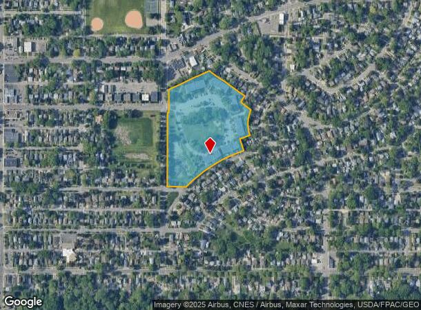
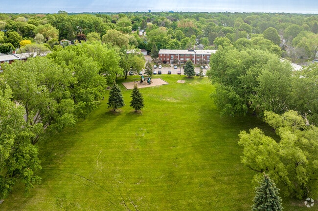
Property Record
806 Hazel St N, Saint Paul, MN 55119

NEARBY LISTINGS FOR SALE OR LEASE
Property Detail
806 Hazel St N
Minneapolis-St. Paul-Bloomington, MN-WI
Beaver Lake Heights
26-29-22-34-0167
BEAVER LAKE HEIGHTS PART DESC AS BEG AT A PT OF INTERSECTION WITH ...TO THE POB OF LOTS B,C AND LOT D
Apartment
Ramsey
X
Minnesota
27037C0050E
b
2024
10.11 AC
2025
Beaver Lake Heights
031802
Minneapolis/St Paul
67,392 SF
DEMOGRAPHICS near 806 Hazel St N
1 Mile
3 Mile
5 Mile
2024 Total Population
21,432
122,933
271,618
2029 Population
20,810
120,448
269,621
Pop Growth 2024-2029
(2.90%)
(2.02%)
(0.74%)
Average Age
34
36
37
2024 Total Households
7,142
42,323
101,158
HH Growth 2024-2029
(3.14%)
(1.96%)
(0.54%)
Median Household Inc
$61,893
$63,250
$66,224
Avg Household Size
2.80
2.70
2.50
2024 Avg HH Vehicles
2.00
2.00
2.00
Median Home Value
$190,098
$227,057
$252,819
Median Year Built
1958
1963
1970
Nearby Places
Map Layers
Map Styles
 Street
 Aerial
- Restaurants
- Banks
- Shops
- Fitness
- Groceries
PUBLIC TRANSPORTATION
COMMUTER RAIL
St. Paul-Minneapolis (Empire Builder - Amtrak)
DRIVE
WALK
Distance
St. Paul-Minneapolis (Empire Builder - Amtrak)
8 min
4.3 mi
AIRPORT
Minneapolis-St Paul International/Wold-Chamberlain
DRIVE
WALK
Distance
Minneapolis-St Paul International/Wold-Chamberlain
23 min
14.4 mi
Freight Ports
Port Milwaukee
DRIVE
WALK
Distance
Port Milwaukee
360 min
327.0 mi
Nearby Properties
Address
Land Use
TOTAL SIZE
Lot Size
Zoning
Address
Land Use
TOTAL SIZE
Lot Size
Zoning
267,948 SF
372.92 AC
Address
Land Use
TOTAL SIZE
Lot Size
Zoning
270,348 SF
35.96 AC
Address
Land Use
TOTAL SIZE
Lot Size
Zoning
127,888 SF
141.04 AC
Address
Land Use
TOTAL SIZE
Lot Size
Zoning
460,439 SF
25.26 AC
Address
Land Use
TOTAL SIZE
Lot Size
Zoning
29.55 AC
Address
Land Use
TOTAL SIZE
Lot Size
Zoning
47,670 SF
179 AC
Address
Land Use
TOTAL SIZE
Lot Size
Zoning
32,159 SF
448.26 AC
Address
Land Use
TOTAL SIZE
Lot Size
Zoning
3,080 SF
9.37 AC
Address
Land Use
TOTAL SIZE
Lot Size
Zoning
273,937 SF
16.75 AC
Address
Land Use
TOTAL SIZE
Lot Size
Zoning
53,851 SF
22.74 AC
Address
Land Use
TOTAL SIZE
Lot Size
Zoning
311,332 SF
36.34 AC
Address
Land Use
TOTAL SIZE
Lot Size
Zoning
181.88 AC
Address
Land Use
TOTAL SIZE
Lot Size
Zoning
246,000 SF
31.03 AC
Address
Land Use
TOTAL SIZE
Lot Size
Zoning
138,407 SF
15.67 AC
Address
Land Use
TOTAL SIZE
Lot Size
Zoning
64,563 SF
1.05 AC
Address
Land Use
TOTAL SIZE
Lot Size
Zoning
297,750 SF
11.54 AC
Address
Land Use
TOTAL SIZE
Lot Size
Zoning
262,872 SF
14.22 AC
Address
Land Use
TOTAL SIZE
Lot Size
Zoning
96,587 SF
17.42 AC
Address
Land Use
TOTAL SIZE
Lot Size
Zoning
41,201 SF
9.55 AC
Address
Land Use
TOTAL SIZE
Lot Size
Zoning
256,440 SF
27.44 AC
Address
Land Use
TOTAL SIZE
Lot Size
Zoning
221,625 SF
3.94 AC
Address
Land Use
TOTAL SIZE
Lot Size
Zoning
371,200 SF
8.99 AC
Address
Land Use
TOTAL SIZE
Lot Size
Zoning
222,374 SF
43.99 AC
Address
Land Use
TOTAL SIZE
Lot Size
Zoning
49,691 SF
10.94 AC
Address
Land Use
TOTAL SIZE
Lot Size
Zoning
Address
Land Use
TOTAL SIZE
Lot Size
Zoning
92,091 SF
2.78 AC
Address
Land Use
TOTAL SIZE
Lot Size
Zoning
188,160 SF
7.53 AC
Address
Land Use
TOTAL SIZE
Lot Size
Zoning
190,062 SF
6.99 AC
Address
Land Use
TOTAL SIZE
Lot Size
Zoning
301,658 SF
21.92 AC
Address
Land Use
TOTAL SIZE
Lot Size
Zoning
192,600 SF
11 AC
The World's #1 Commercial Real Estate Marketplace
Connect with us
© 2025 CoStar Group
The information above has been obtained from sources believed reliable. While we do not doubt its accuracy we have not verified it and make no guarantee, warranty or representation about it. It is your responsibility to independently confirm its accuracy and completeness. Any projections, opinions, assumptions, or estimates used are for example only and do not represent the current or future performance of the property. The value of this transaction to you depends on tax and other factors which should be evaluated by your tax, financial, and legal advisors. You and your advisors should conduct a careful, independent investigation of the property to determine to your satisfaction the suitability of the property for your needs.