Property Record
806 Route 17 N, Ramsey, NJ 07446


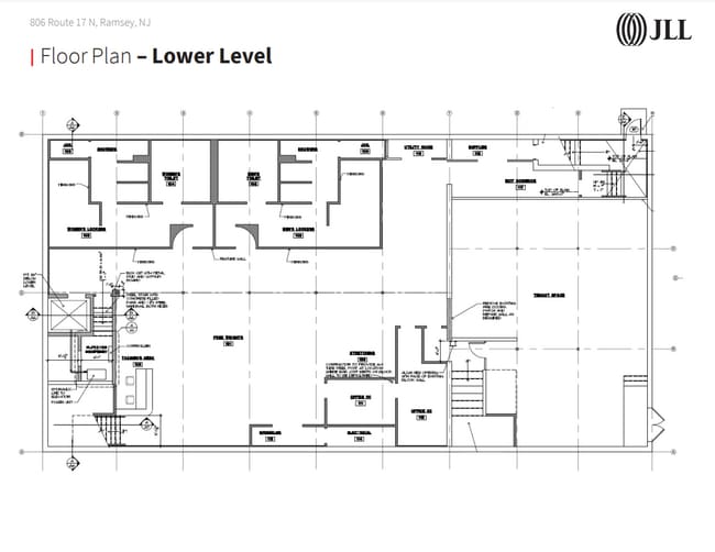

Current Lease Availabilities
NEARBY LISTINGS FOR SALE OR LEASE
Property Detail
806 Route 17 N
48-04702-0000-00004
1.714AC
Commercialnec
Bergen
AE
New Jersey
34003C0059H
4
2024
1.71 AC
2025
North 17 Corridor
044202
Northern New Jersey
8,560 SF
New York-Jersey City-White Plains, NY-NJ
DEMOGRAPHICS near 806 Route 17 N
1 Mile
3 Mile
5 Mile
2024 Total Population
9,347
61,639
180,636
2029 Population
9,429
61,897
180,431
Pop Growth 2024-2029
+ 0.88%
+ 0.42%
(0.11%)
Average Age
43
43
39
2024 Total Households
3,568
22,904
59,242
HH Growth 2024-2029
+ 0.64%
+ 0.32%
(0.09%)
Median Household Inc
$149,964
$132,661
$122,402
Avg Household Size
2.60
2.60
2.90
2024 Avg HH Vehicles
2.00
2.00
2.00
Median Home Value
$704,181
$695,447
$698,245
Median Year Built
1976
1976
1970
Nearby Places
Map Layers
Map Styles
 Street
 Aerial
- Restaurants
- Banks
- Shops
- Fitness
- Groceries
PUBLIC TRANSPORTATION
COMMUTER RAIL
Ramsey (Bergen County/Port Jervis Line - NJ Transit Commuter Rail (NJ Transit), Main/Port Jervis Line - NJ Transit Commuter Rail (NJ Transit))
DRIVE
WALK
Distance
Ramsey (Bergen County/Port Jervis Line - NJ Transit Commuter Rail (NJ Transit), Main/Port Jervis Line - NJ Transit Commuter Rail (NJ Transit))
6 min
2.4 mi
Mahwah (Bergen County/Port Jervis Line - NJ Transit Commuter Rail (NJ Transit), Main/Port Jervis Line - NJ Transit Commuter Rail (NJ Transit))
DRIVE
WALK
Distance
Mahwah (Bergen County/Port Jervis Line - NJ Transit Commuter Rail (NJ Transit), Main/Port Jervis Line - NJ Transit Commuter Rail (NJ Transit))
5 min
2.6 mi
AIRPORT
LaGuardia
DRIVE
WALK
Distance
LaGuardia
48 min
31.3 mi
Newark Liberty International
DRIVE
WALK
Distance
Newark Liberty International
41 min
31.7 mi
Westchester County
DRIVE
WALK
Distance
Westchester County
48 min
32.5 mi
Freight Ports
Maher Terminal
DRIVE
WALK
Distance
Maher Terminal
50 min
33.8 mi
Nearby Properties
Address
Land Use
TOTAL SIZE
Lot Size
Zoning
Address
Land Use
TOTAL SIZE
Lot Size
Zoning
284 AC
P40
Address
Land Use
TOTAL SIZE
Lot Size
Zoning
28.44 AC
Address
Land Use
TOTAL SIZE
Lot Size
Zoning
28.28 AC
GI80
Address
Land Use
TOTAL SIZE
Lot Size
Zoning
39.50 AC
Address
Land Use
TOTAL SIZE
Lot Size
Zoning
46.89 AC
IP120
Address
Land Use
TOTAL SIZE
Lot Size
Zoning
40.40 AC
PU
Address
Land Use
TOTAL SIZE
Lot Size
Zoning
61.37 AC
PED
Address
Land Use
TOTAL SIZE
Lot Size
Zoning
17.71 AC
B3
Address
Land Use
TOTAL SIZE
Lot Size
Zoning
2,379 SF
1.09 AC
LI
Address
Land Use
TOTAL SIZE
Lot Size
Zoning
7.11 AC
Address
Land Use
TOTAL SIZE
Lot Size
Zoning
13 AC
EAO
Address
Land Use
TOTAL SIZE
Lot Size
Zoning
16.02 AC
R3
Address
Land Use
TOTAL SIZE
Lot Size
Zoning
17 AC
OR1
Address
Land Use
TOTAL SIZE
Lot Size
Zoning
Address
Land Use
TOTAL SIZE
Lot Size
Zoning
31.79 AC
OR2
Address
Land Use
TOTAL SIZE
Lot Size
Zoning
Address
Land Use
TOTAL SIZE
Lot Size
Zoning
38.65 AC
Address
Land Use
TOTAL SIZE
Lot Size
Zoning
10.38 AC
Address
Land Use
TOTAL SIZE
Lot Size
Zoning
10.64 AC
AAA
Address
Land Use
TOTAL SIZE
Lot Size
Zoning
6.52 AC
Address
Land Use
TOTAL SIZE
Lot Size
Zoning
17.90 AC
IP
Address
Land Use
TOTAL SIZE
Lot Size
Zoning
2.33 AC
B3
Address
Land Use
TOTAL SIZE
Lot Size
Zoning
20 AC
ORP200
Address
Land Use
TOTAL SIZE
Lot Size
Zoning
170,941 SF
10.04 AC
IP
Address
Land Use
TOTAL SIZE
Lot Size
Zoning
124,528 SF
8.87 AC
EM
Address
Land Use
TOTAL SIZE
Lot Size
Zoning
14.09 AC
B200
Address
Land Use
TOTAL SIZE
Lot Size
Zoning
106,836 SF
8.85 AC
LO
Address
Land Use
TOTAL SIZE
Lot Size
Zoning
Address
Land Use
TOTAL SIZE
Lot Size
Zoning
15.98 AC
Address
Land Use
TOTAL SIZE
Lot Size
Zoning
6.29 AC
B3
The World's #1 Commercial Real Estate Marketplace
Connect with us
© 2025 CoStar Group
The information above has been obtained from sources believed reliable. While we do not doubt its accuracy we have not verified it and make no guarantee, warranty or representation about it. It is your responsibility to independently confirm its accuracy and completeness. Any projections, opinions, assumptions, or estimates used are for example only and do not represent the current or future performance of the property. The value of this transaction to you depends on tax and other factors which should be evaluated by your tax, financial, and legal advisors. You and your advisors should conduct a careful, independent investigation of the property to determine to your satisfaction the suitability of the property for your needs.