Property Record
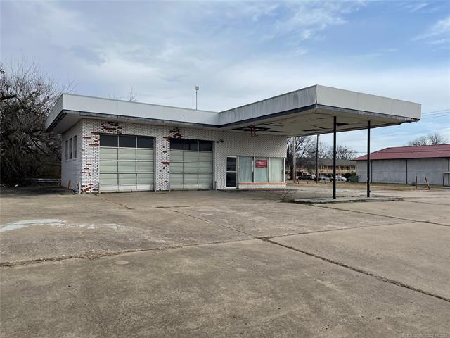
806 S 32Nd St, Muskogee, OK 74401


Property Detail
806 S 32Nd St
12242
ELMWOOD PLACE S20 LOT 8 & E153.74 LOT 9 BLOCK 4
Autorepair
Muskogee
E1
Oklahoma
B and X Area of moderate flood hazard, usually the area between the limits of the 100-year and 500-year floods.
8,9
0
0.44 AC
2025
Muskogee County
000100
Tulsa
1,276 SF
Muskogee, OK
NEARBY LISTINGS FOR SALE OR LEASE
DEMOGRAPHICS near 806 S 32Nd St
1 mile
3 mile
5 mile
2025 Total Population
5,260
22,011
39,865
2030 Population
5,352
22,573
40,464
Pop Growth 2025-2030
+ 1.75%
+ 2.55%
+ 1.50%
Average Age
39
39
39
2025 Total Households
2,161
8,874
16,073
HH Growth 2025-2030
+ 1.71%
+ 2.63%
+ 1.57%
Median Household Inc
$47,056
$43,782
$50,519
Avg Household Size
2.20
2.30
2.30
2025 Avg HH Vehicles
2.00
2.00
2.00
Median Home Value
$116,361
$105,207
$140,850
Median Year Built
1960
1965
1971
Nearby Places
Map Layers
Map Styles
 Street
 Aerial
Layers
 Traffic
 Biking
Places
Listings with unknown addresses are not visible on the map
- Restaurants
- Banks
- Shops
- Fitness
- Groceries
PUBLIC TRANSPORTATION
AIRPORT
Tulsa International
Drive
Walk
Distance
Tulsa International
60 min
49.9 mi
SALE & LEASE HISTORY
LISTING DATE
SALE/LEASE

Jul 17, 2017
For Sale
Feb 18, 2019
For Sale
Feb 02, 2022
For Sale
Nearby Properties
Address
Land Use
TOTAL SIZE
Lot Size
Zoning
Address
Land Use
TOTAL SIZE
Lot Size
Zoning
49,127 SF
34.96 AC
Address
Land Use
TOTAL SIZE
Lot Size
Zoning
7,312 SF
27.94 AC
Address
Land Use
TOTAL SIZE
Lot Size
Zoning
69,776 SF
20.13 AC
Address
Land Use
TOTAL SIZE
Lot Size
Zoning
35,708 SF
77.67 AC
Address
Land Use
TOTAL SIZE
Lot Size
Zoning
71,364 SF
3.48 AC
F
Address
Land Use
TOTAL SIZE
Lot Size
Zoning
51,422 SF
9.45 AC
Address
Land Use
TOTAL SIZE
Lot Size
Zoning
2,000 SF
9.08 AC
Address
Land Use
TOTAL SIZE
Lot Size
Zoning
19,548 SF
3.77 AC
B
Address
Land Use
TOTAL SIZE
Lot Size
Zoning
125,980 SF
99.24 AC
Address
Land Use
TOTAL SIZE
Lot Size
Zoning
43,002 SF
1.09 AC
MI
Address
Land Use
TOTAL SIZE
Lot Size
Zoning
17,764 SF
5.40 AC
Address
Land Use
TOTAL SIZE
Lot Size
Zoning
41,924 SF
1.51 AC
MI
Address
Land Use
TOTAL SIZE
Lot Size
Zoning
11,474 SF
5.02 AC
G
Address
Land Use
TOTAL SIZE
Lot Size
Zoning
432 SF
5.21 AC
MI
Address
Land Use
TOTAL SIZE
Lot Size
Zoning
6,720 SF
20 AC
D
Address
Land Use
TOTAL SIZE
Lot Size
Zoning
5,040 SF
8.40 AC
Address
Land Use
TOTAL SIZE
Lot Size
Zoning
21,332 SF
5.51 AC
Address
Land Use
TOTAL SIZE
Lot Size
Zoning
21,252 SF
2.49 AC
Address
Land Use
TOTAL SIZE
Lot Size
Zoning
84,918 SF
1.21 AC
D
Address
Land Use
TOTAL SIZE
Lot Size
Zoning
34,070 SF
2.33 AC
PP
Address
Land Use
TOTAL SIZE
Lot Size
Zoning
11,071 SF
1.86 AC
Address
Land Use
TOTAL SIZE
Lot Size
Zoning
6,000 SF
1.39 AC
Address
Land Use
TOTAL SIZE
Lot Size
Zoning
600,300 SF
3.96 AC
PP
Address
Land Use
TOTAL SIZE
Lot Size
Zoning
17,000 SF
30.60 AC
Address
Land Use
TOTAL SIZE
Lot Size
Zoning
4,812 SF
1.46 AC
E1
Address
Land Use
TOTAL SIZE
Lot Size
Zoning
37,260 SF
1.93 AC
Address
Land Use
TOTAL SIZE
Lot Size
Zoning
13,810 SF
13.10 AC
Address
Land Use
TOTAL SIZE
Lot Size
Zoning
4,752 SF
1.29 AC
B
Address
Land Use
TOTAL SIZE
Lot Size
Zoning
51,616 SF
2.98 AC
PP
The World's #1 Commercial Real Estate Marketplace
Connect with us
© 2026 CoStar Group
The information above has been obtained from sources believed reliable. While we do not doubt its accuracy we have not verified it and make no guarantee, warranty or representation about it. It is your responsibility to independently confirm its accuracy and completeness. Any projections, opinions, assumptions, or estimates used are for example only and do not represent the current or future performance of the property. The value of this transaction to you depends on tax and other factors which should be evaluated by your tax, financial, and legal advisors. You and your advisors should conduct a careful, independent investigation of the property to determine to your satisfaction the suitability of the property for your needs.