Property Record
806 W Miami St, Paola, KS 66071
NEARBY LISTINGS FOR SALE OR LEASE
Property Detail
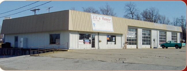
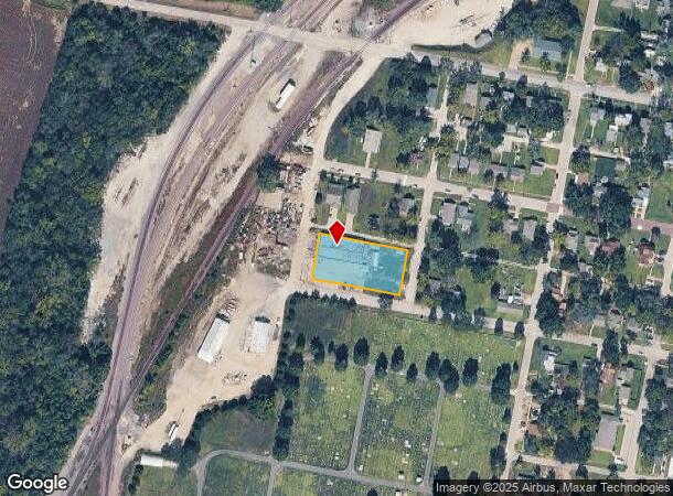
806 W Miami St
Kansas City, MO-KS
Snyder's Addn Paola
134-17-0-10-14-005.00-0
SNYDER'S ADDN PAOLA, BLOCK 8, LOT 11 - 20, LOTS 11-20 BLK 8 SNYDERS ADDN SECTION 17 TOWNSHIP 17 RANGE 23
Autorepair
Miami
X
Kansas
20121C0159D
11-20
2025
0.65 AC
2025
Outer South Kansas City
100601
Kansas City
7,200 SF
DEMOGRAPHICS near 806 W Miami St
1 Mile
3 Mile
5 Mile
2024 Total Population
3,281
7,090
8,930
2029 Population
3,444
7,390
9,309
Pop Growth 2024-2029
+ 4.97%
+ 4.23%
+ 4.24%
Average Age
38
41
42
2024 Total Households
1,278
2,906
3,630
HH Growth 2024-2029
+ 5.09%
+ 4.27%
+ 4.30%
Median Household Inc
$72,005
$69,712
$72,260
Avg Household Size
2.40
2.30
2.30
2024 Avg HH Vehicles
2.00
2.00
2.00
Median Home Value
$160,504
$196,243
$218,760
Median Year Built
1947
1969
1972
Nearby Places
- Restaurants
- Banks
- Shops
- Fitness
- Groceries
Nearby Properties
Address
Land Use
TOTAL SIZE
Lot Size
Zoning
Address
Land Use
TOTAL SIZE
Lot Size
Zoning
45,759 SF
63.69 AC
Address
Land Use
TOTAL SIZE
Lot Size
Zoning
29,348 SF
0.81 AC
Address
Land Use
TOTAL SIZE
Lot Size
Zoning
52,836 SF
7.26 AC
Address
Land Use
TOTAL SIZE
Lot Size
Zoning
11,250 SF
30.50 AC
Address
Land Use
TOTAL SIZE
Lot Size
Zoning
64,224 SF
37.95 AC
Address
Land Use
TOTAL SIZE
Lot Size
Zoning
27,400 SF
0.77 AC
Address
Land Use
TOTAL SIZE
Lot Size
Zoning
26,316 SF
6.15 AC
Address
Land Use
TOTAL SIZE
Lot Size
Zoning
7,200 SF
15.23 AC
PGA
Address
Land Use
TOTAL SIZE
Lot Size
Zoning
29,054 SF
18.25 AC
Address
Land Use
TOTAL SIZE
Lot Size
Zoning
8,424 SF
1.86 AC
Address
Land Use
TOTAL SIZE
Lot Size
Zoning
37,296 SF
1.74 AC
Address
Land Use
TOTAL SIZE
Lot Size
Zoning
17,264 SF
2.45 AC
Address
Land Use
TOTAL SIZE
Lot Size
Zoning
2,248 SF
0.27 AC
Address
Land Use
TOTAL SIZE
Lot Size
Zoning
23,563 SF
5.25 AC
Address
Land Use
TOTAL SIZE
Lot Size
Zoning
25,784 SF
1.73 AC
Address
Land Use
TOTAL SIZE
Lot Size
Zoning
8,791 SF
0.13 AC
Address
Land Use
TOTAL SIZE
Lot Size
Zoning
144,904 SF
18.23 AC
Address
Land Use
TOTAL SIZE
Lot Size
Zoning
16,780 SF
8.17 AC
Address
Land Use
TOTAL SIZE
Lot Size
Zoning
25,048 SF
4.88 AC
Address
Land Use
TOTAL SIZE
Lot Size
Zoning
684 SF
18.52 AC
PGA
Address
Land Use
TOTAL SIZE
Lot Size
Zoning
3,532 SF
2.96 AC
Address
Land Use
TOTAL SIZE
Lot Size
Zoning
2,400 SF
2.91 AC
Address
Land Use
TOTAL SIZE
Lot Size
Zoning
6,606 SF
9.80 AC
Address
Land Use
TOTAL SIZE
Lot Size
Zoning
5,908 SF
8.50 AC
OGA
Address
Land Use
TOTAL SIZE
Lot Size
Zoning
13,552 SF
4.50 AC
PGA
Address
Land Use
TOTAL SIZE
Lot Size
Zoning
108,696 SF
12.01 AC
Address
Land Use
TOTAL SIZE
Lot Size
Zoning
5,992 SF
0.70 AC
Address
Land Use
TOTAL SIZE
Lot Size
Zoning
15,000 SF
4.27 AC
Address
Land Use
TOTAL SIZE
Lot Size
Zoning
12,626 SF
0.55 AC
Address
Land Use
TOTAL SIZE
Lot Size
Zoning
3,825 SF
0.48 AC
The World's #1 Commercial Real Estate Marketplace
Connect with us
© 2025 CoStar Group
The information above has been obtained from sources believed reliable. While we do not doubt its accuracy we have not verified it and make no guarantee, warranty or representation about it. It is your responsibility to independently confirm its accuracy and completeness. Any projections, opinions, assumptions, or estimates used are for example only and do not represent the current or future performance of the property. The value of this transaction to you depends on tax and other factors which should be evaluated by your tax, financial, and legal advisors. You and your advisors should conduct a careful, independent investigation of the property to determine to your satisfaction the suitability of the property for your needs.