No Photo
Property Record
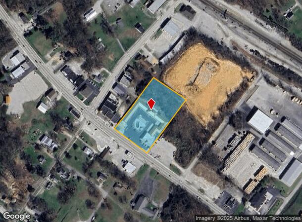
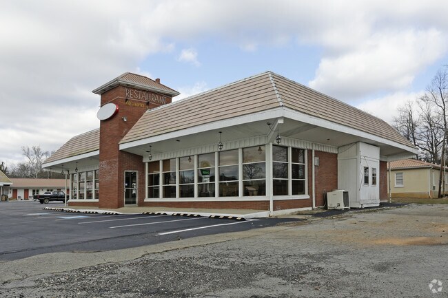
8064 S Highway 27, Burnside, KY 42519

NEARBY LISTINGS FOR SALE OR LEASE
-
-
View all Burnside listings for lease on LoopNet.com
Property Detail
8064 S Highway 27
064-7-2-22
Burnside Realty Company Sub
Motel
S HWY 27 MOTEL & REST
X
Pulaski
21199C0430C
Kentucky
2024
2.38 AC
2025
Corbin/London Area
931104
Other Market Areas
3,500 SF
Somerset, KY
DEMOGRAPHICS near 8064 S Highway 27
1 Mile
3 Mile
5 Mile
2024 Total Population
612
6,888
17,254
2029 Population
618
7,108
17,777
Pop Growth 2024-2029
+ 0.98%
+ 3.19%
+ 3.03%
Average Age
44
41
42
2024 Total Households
252
2,850
7,124
HH Growth 2024-2029
+ 0.79%
+ 3.16%
+ 2.99%
Median Household Inc
$44,238
$38,966
$46,358
Avg Household Size
2.40
2.40
2.40
2024 Avg HH Vehicles
2.00
2.00
2.00
Median Home Value
$155,357
$121,980
$153,314
Median Year Built
1972
1983
1987
Nearby Places
Map Layers
Map Styles
 Street
 Aerial
- Restaurants
- Banks
- Shops
- Fitness
- Groceries
SALE & LEASE HISTORY
LISTING DATE
SALE/LEASE

Jan 18, 2017
For Lease
Nearby Properties
Address
Land Use
TOTAL SIZE
Lot Size
Zoning
Address
Land Use
TOTAL SIZE
Lot Size
Zoning
5.80 AC
Address
Land Use
TOTAL SIZE
Lot Size
Zoning
672 SF
74.90 AC
Address
Land Use
TOTAL SIZE
Lot Size
Zoning
10,336 SF
5.80 AC
Address
Land Use
TOTAL SIZE
Lot Size
Zoning
10.59 AC
Address
Land Use
TOTAL SIZE
Lot Size
Zoning
1,600 SF
2.48 AC
Address
Land Use
TOTAL SIZE
Lot Size
Zoning
792 SF
2.19 AC
Address
Land Use
TOTAL SIZE
Lot Size
Zoning
27.12 AC
Address
Land Use
TOTAL SIZE
Lot Size
Zoning
68,376 SF
10.76 AC
Address
Land Use
TOTAL SIZE
Lot Size
Zoning
Address
Land Use
TOTAL SIZE
Lot Size
Zoning
Address
Land Use
TOTAL SIZE
Lot Size
Zoning
1,600 SF
1.59 AC
Address
Land Use
TOTAL SIZE
Lot Size
Zoning
1,890 AC
Address
Land Use
TOTAL SIZE
Lot Size
Zoning
2,000 SF
27.84 AC
Address
Land Use
TOTAL SIZE
Lot Size
Zoning
0.82 AC
Address
Land Use
TOTAL SIZE
Lot Size
Zoning
4,437 SF
1.28 AC
Address
Land Use
TOTAL SIZE
Lot Size
Zoning
1.27 AC
Address
Land Use
TOTAL SIZE
Lot Size
Zoning
15,000 SF
13.20 AC
Address
Land Use
TOTAL SIZE
Lot Size
Zoning
1.45 AC
Address
Land Use
TOTAL SIZE
Lot Size
Zoning
0.92 AC
Address
Land Use
TOTAL SIZE
Lot Size
Zoning
7,436 SF
1.32 AC
Address
Land Use
TOTAL SIZE
Lot Size
Zoning
1.03 AC
Address
Land Use
TOTAL SIZE
Lot Size
Zoning
10,836 SF
8.98 AC
Address
Land Use
TOTAL SIZE
Lot Size
Zoning
3.27 AC
Address
Land Use
TOTAL SIZE
Lot Size
Zoning
6,724 SF
1.24 AC
Address
Land Use
TOTAL SIZE
Lot Size
Zoning
Address
Land Use
TOTAL SIZE
Lot Size
Zoning
Address
Land Use
TOTAL SIZE
Lot Size
Zoning
5,000 SF
0.81 AC
Address
Land Use
TOTAL SIZE
Lot Size
Zoning
1.34 AC
Address
Land Use
TOTAL SIZE
Lot Size
Zoning
1,800 SF
2 AC
Address
Land Use
TOTAL SIZE
Lot Size
Zoning
9,869 SF
4 AC
The World's #1 Commercial Real Estate Marketplace
Connect with us
© 2025 CoStar Group
The information above has been obtained from sources believed reliable. While we do not doubt its accuracy we have not verified it and make no guarantee, warranty or representation about it. It is your responsibility to independently confirm its accuracy and completeness. Any projections, opinions, assumptions, or estimates used are for example only and do not represent the current or future performance of the property. The value of this transaction to you depends on tax and other factors which should be evaluated by your tax, financial, and legal advisors. You and your advisors should conduct a careful, independent investigation of the property to determine to your satisfaction the suitability of the property for your needs.