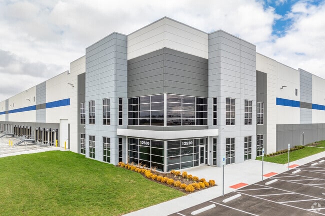
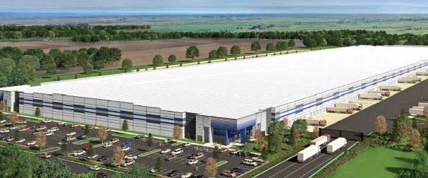
Property Record
8065 Mink St Sw, Pataskala, OH 43062
NEARBY LISTINGS FOR SALE OR LEASE
Property Detail
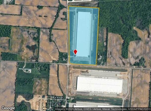
8065 Mink St Sw
Columbus, OH
Sw Quarter
063-141516-00.000
93.785 AC LOT 1 & 2 R15 T1 Q3 TAX ABATE CRA 2024-2038
Warehouse
Licking
X
Ohio
39089C0426J
1
2024
93.78 AC
2024
Licking County
756500
Columbus
2,556 SF
DEMOGRAPHICS near 8065 Mink St Sw
1 Mile
3 Mile
5 Mile
2024 Total Population
628
26,273
106,116
2029 Population
660
27,510
109,408
Pop Growth 2024-2029
+ 5.10%
+ 4.71%
+ 3.10%
Average Age
41
39
38
2024 Total Households
241
9,245
38,370
HH Growth 2024-2029
+ 4.98%
+ 4.69%
+ 2.99%
Median Household Inc
$78,750
$94,549
$87,362
Avg Household Size
2.60
2.80
2.70
2024 Avg HH Vehicles
2.00
2.00
2.00
Median Home Value
$214,474
$237,126
$251,774
Median Year Built
1975
1995
1995
Nearby Places
Map Layers
Map Styles
 Street
 Aerial
- Restaurants
- Banks
- Shops
- Fitness
- Groceries
PUBLIC TRANSPORTATION
AIRPORT
John Glenn Columbus International
DRIVE
WALK
Distance
John Glenn Columbus International
22 min
12.7 mi
Rickenbacker International
DRIVE
WALK
Distance
Rickenbacker International
31 min
19.6 mi
Freight Ports
Port of Toledo
DRIVE
WALK
Distance
Port of Toledo
197 min
156.0 mi
SALE & LEASE HISTORY
LISTING DATE
SALE/LEASE

May 18, 2021
For Lease
Nearby Properties
Address
Land Use
TOTAL SIZE
Lot Size
Zoning
Address
Land Use
TOTAL SIZE
Lot Size
Zoning
1,230,350 SF
78.26 AC
Address
Land Use
TOTAL SIZE
Lot Size
Zoning
1,091,997 SF
49.37 AC
Address
Land Use
TOTAL SIZE
Lot Size
Zoning
1,014,005 SF
101.26 AC
Address
Land Use
TOTAL SIZE
Lot Size
Zoning
855,000 SF
96 AC
Address
Land Use
TOTAL SIZE
Lot Size
Zoning
588,910 SF
52.23 AC
Address
Land Use
TOTAL SIZE
Lot Size
Zoning
437,569 SF
33 AC
Address
Land Use
TOTAL SIZE
Lot Size
Zoning
700,491 SF
92.80 AC
Address
Land Use
TOTAL SIZE
Lot Size
Zoning
699,016 SF
43.57 AC
Address
Land Use
TOTAL SIZE
Lot Size
Zoning
Address
Land Use
TOTAL SIZE
Lot Size
Zoning
1,003,816 SF
75.60 AC
Address
Land Use
TOTAL SIZE
Lot Size
Zoning
978,491 SF
72.31 AC
Address
Land Use
TOTAL SIZE
Lot Size
Zoning
756,333 SF
44.37 AC
Address
Land Use
TOTAL SIZE
Lot Size
Zoning
705,707 SF
107.11 AC
Address
Land Use
TOTAL SIZE
Lot Size
Zoning
51,958 SF
48.39 AC
Address
Land Use
TOTAL SIZE
Lot Size
Zoning
524,490 SF
25.40 AC
Address
Land Use
TOTAL SIZE
Lot Size
Zoning
524,494 SF
25.67 AC
Address
Land Use
TOTAL SIZE
Lot Size
Zoning
137,136 SF
69.71 AC
Address
Land Use
TOTAL SIZE
Lot Size
Zoning
410,332 SF
21.81 AC
Address
Land Use
TOTAL SIZE
Lot Size
Zoning
512,267 SF
22.36 AC
Address
Land Use
TOTAL SIZE
Lot Size
Zoning
201,687 SF
20.97 AC
Address
Land Use
TOTAL SIZE
Lot Size
Zoning
47.69 AC
Address
Land Use
TOTAL SIZE
Lot Size
Zoning
303,408 SF
29.74 AC
Address
Land Use
TOTAL SIZE
Lot Size
Zoning
82,450 SF
28.27 AC
Address
Land Use
TOTAL SIZE
Lot Size
Zoning
2,171 SF
14.44 AC
Address
Land Use
TOTAL SIZE
Lot Size
Zoning
53,199 SF
50.28 AC
Address
Land Use
TOTAL SIZE
Lot Size
Zoning
83,892 SF
15.80 AC
Address
Land Use
TOTAL SIZE
Lot Size
Zoning
4,208 SF
15.91 AC
Address
Land Use
TOTAL SIZE
Lot Size
Zoning
472,029 SF
59.94 AC
Address
Land Use
TOTAL SIZE
Lot Size
Zoning
105,628 SF
17.72 AC
The World's #1 Commercial Real Estate Marketplace
Connect with us
© 2026 CoStar Group
The information above has been obtained from sources believed reliable. While we do not doubt its accuracy we have not verified it and make no guarantee, warranty or representation about it. It is your responsibility to independently confirm its accuracy and completeness. Any projections, opinions, assumptions, or estimates used are for example only and do not represent the current or future performance of the property. The value of this transaction to you depends on tax and other factors which should be evaluated by your tax, financial, and legal advisors. You and your advisors should conduct a careful, independent investigation of the property to determine to your satisfaction the suitability of the property for your needs.