Property Record
8068 W Beaver St, Jacksonville, FL 32220
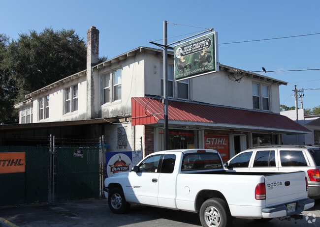

This Property Is For Sale
NEARBY LISTINGS FOR SALE OR LEASE
Property Detail
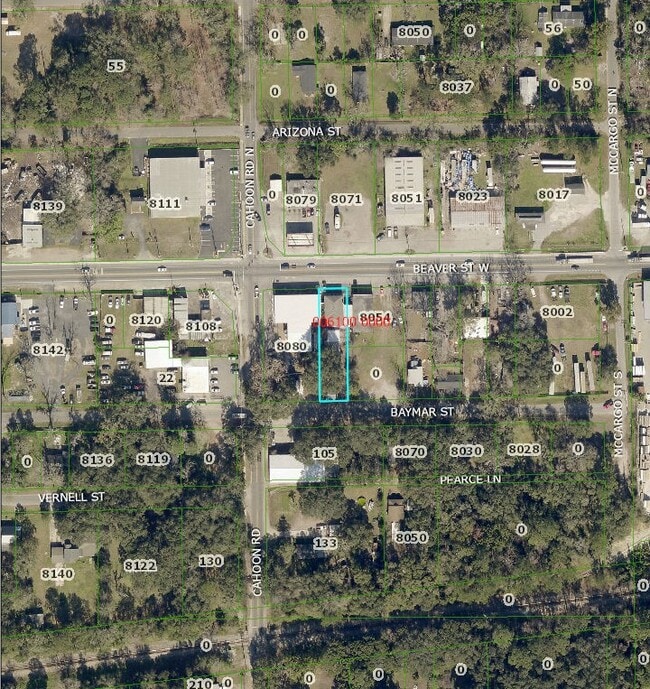
8068 W Beaver St
006100-0000
Peninsular Life Insurance Company's Repl
Commercialofficeresidentialmixeduse
15-4 15-2S-25E .25 PENINSULAR LIFE INS CO R/P 2 W 52.5FT OF E 210FT TRACT 9
X
Duval
12031C0333H
Florida
2025
0.25 AC
2026
Northwest Jacksonville
011901
Jacksonville (Florida)
6,301 SF
Jacksonville, FL
DEMOGRAPHICS near 8068 W Beaver St
1 mile
3 mile
5 mile
2024 Total Population
4,066
37,438
123,951
2029 Population
4,272
39,312
129,959
Pop Growth 2024-2029
+ 5.07%
+ 5.01%
+ 4.85%
Average Age
41
39
38
2024 Total Households
1,556
14,160
48,365
HH Growth 2024-2029
+ 5.21%
+ 5.16%
+ 4.95%
Median Household Inc
$52,318
$55,453
$52,951
Avg Household Size
2.50
2.50
2.50
2024 Avg HH Vehicles
2.00
2.00
2.00
Median Home Value
$163,560
$176,768
$183,782
Median Year Built
1978
1981
1972
Nearby Places
Map Layers
Map Styles
 Street
 Aerial
Transit
 Traffic
 Biking
Places
Listings with unknown addresses are not visible on the map
- Restaurants
- Banks
- Shops
- Fitness
- Groceries
PUBLIC TRANSPORTATION
COMMUTER RAIL
Drive
Walk
Distance
14 min
6.8 mi
AIRPORT
Jacksonville International
Drive
Walk
Distance
Jacksonville International
28 min
17.4 mi
Freight Ports
Jacksonville Port
Drive
Walk
Distance
Jacksonville Port
21 min
12.4 mi
Nearby Properties
Address
Land Use
TOTAL SIZE
Lot Size
Zoning
Address
Land Use
TOTAL SIZE
Lot Size
Zoning
744,280 SF
53.40 AC
RMD-D
Address
Land Use
TOTAL SIZE
Lot Size
Zoning
600,857 SF
38.14 AC
IL
Address
Land Use
TOTAL SIZE
Lot Size
Zoning
506,816 SF
39.32 AC
IBP
Address
Land Use
TOTAL SIZE
Lot Size
Zoning
874,178 SF
46.91 AC
PBF-2
Address
Land Use
TOTAL SIZE
Lot Size
Zoning
465,664 SF
21.27 AC
IL
Address
Land Use
TOTAL SIZE
Lot Size
Zoning
888,083 SF
46.65 AC
IL
Address
Land Use
TOTAL SIZE
Lot Size
Zoning
397,865 SF
42 AC
IL
Address
Land Use
TOTAL SIZE
Lot Size
Zoning
421,500 SF
43.21 AC
PUD
Address
Land Use
TOTAL SIZE
Lot Size
Zoning
321,547 SF
17.17 AC
PUD
Address
Land Use
TOTAL SIZE
Lot Size
Zoning
222,138 SF
13.18 AC
IL
Address
Land Use
TOTAL SIZE
Lot Size
Zoning
505,748 SF
94.71 AC
IL
Address
Land Use
TOTAL SIZE
Lot Size
Zoning
392,050 SF
50.22 AC
PUD
Address
Land Use
TOTAL SIZE
Lot Size
Zoning
307,732 SF
41.23 AC
IL
Address
Land Use
TOTAL SIZE
Lot Size
Zoning
290,599 SF
27.84 AC
RMD-D
Address
Land Use
TOTAL SIZE
Lot Size
Zoning
310,972 SF
19.91 AC
RMD-D
Address
Land Use
TOTAL SIZE
Lot Size
Zoning
233,363 SF
20.36 AC
PUD
Address
Land Use
TOTAL SIZE
Lot Size
Zoning
270,762 SF
39.15 AC
PUD
Address
Land Use
TOTAL SIZE
Lot Size
Zoning
157,289 SF
59.35 AC
RLD-60
Address
Land Use
TOTAL SIZE
Lot Size
Zoning
509,686 SF
43.32 AC
IL
Address
Land Use
TOTAL SIZE
Lot Size
Zoning
139,435 SF
7.15 AC
CCG-2
Address
Land Use
TOTAL SIZE
Lot Size
Zoning
481,686 SF
43.54 AC
IL
Address
Land Use
TOTAL SIZE
Lot Size
Zoning
64,013 SF
8.37 AC
PUD
Address
Land Use
TOTAL SIZE
Lot Size
Zoning
162,283 SF
14.29 AC
IL
Address
Land Use
TOTAL SIZE
Lot Size
Zoning
161,001 SF
10.32 AC
IL
Address
Land Use
TOTAL SIZE
Lot Size
Zoning
209,480 SF
22.42 AC
CCG-1
Address
Land Use
TOTAL SIZE
Lot Size
Zoning
89,150 SF
61.04 AC
RMD-MH
Address
Land Use
TOTAL SIZE
Lot Size
Zoning
54,296 SF
39.10 AC
RLD-60
Address
Land Use
TOTAL SIZE
Lot Size
Zoning
114,316 SF
20.57 AC
IL
Address
Land Use
TOTAL SIZE
Lot Size
Zoning
279,053 SF
21.03 AC
IBP
Address
Land Use
TOTAL SIZE
Lot Size
Zoning
170,550 SF
7.48 AC
IL
The World's #1 Commercial Real Estate Marketplace
Connect with us
© 2026 CoStar Group
The information above has been obtained from sources believed reliable. While we do not doubt its accuracy we have not verified it and make no guarantee, warranty or representation about it. It is your responsibility to independently confirm its accuracy and completeness. Any projections, opinions, assumptions, or estimates used are for example only and do not represent the current or future performance of the property. The value of this transaction to you depends on tax and other factors which should be evaluated by your tax, financial, and legal advisors. You and your advisors should conduct a careful, independent investigation of the property to determine to your satisfaction the suitability of the property for your needs.