Property Record
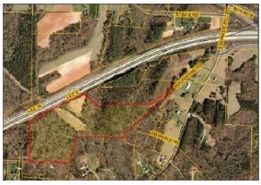
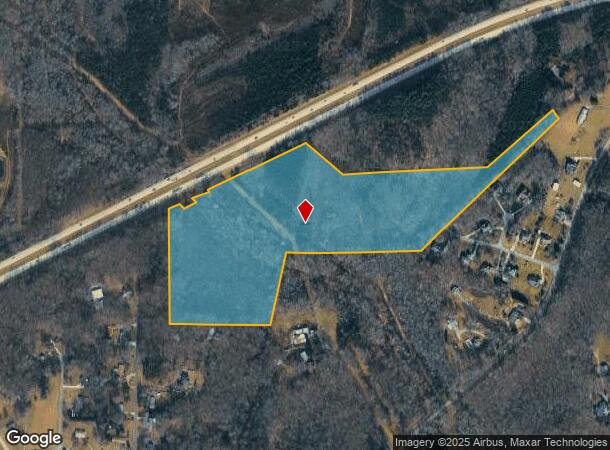
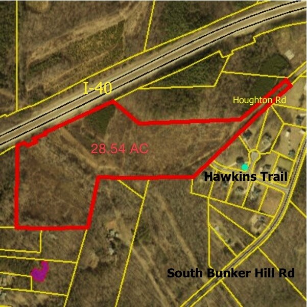
8068 Houghton Rd, Colfax, NC 27235
This Property Is For Sale
NEARBY LISTINGS FOR SALE OR LEASE
Property Detail
8068 Houghton Rd
Greensboro-High Point, NC
Stack
0168968
28.54AC STACK
Residentialnec
Guilford
AE
North Carolina
3710689500K
24
2024
28.54 AC
2025
Airport/W Guilford County
016203
Greensboro/Winston-Salem
DEMOGRAPHICS near 8068 Houghton Rd
1 mile
3 mile
5 mile
2024 Total Population
945
15,410
63,197
2029 Population
959
15,910
64,883
Pop Growth 2024-2029
+ 1.48%
+ 3.24%
+ 2.67%
Average Age
42
43
42
2024 Total Households
419
6,716
25,775
HH Growth 2024-2029
+ 1.67%
+ 3.38%
+ 2.79%
Median Household Inc
$67,391
$64,959
$78,613
Avg Household Size
2.20
2.20
2.40
2024 Avg HH Vehicles
2.00
2.00
2.00
Median Home Value
$304,464
$259,815
$253,193
Median Year Built
1999
1998
1995
Nearby Places
Map Layers
Map Styles
 Street
 Aerial
Transit
 Traffic
 Biking
Places
Listings with unknown addresses are not visible on the map
- Restaurants
- Banks
- Shops
- Fitness
- Groceries
PUBLIC TRANSPORTATION
AIRPORT
Piedmont Triad International
Drive
Walk
Distance
Piedmont Triad International
15 min
7.7 mi
Freight Ports
Virginia Port Authority - Richmond
Drive
Walk
Distance
Virginia Port Authority - Richmond
242 min
211.3 mi
Nearby Properties
Address
Land Use
TOTAL SIZE
Lot Size
Zoning
Address
Land Use
TOTAL SIZE
Lot Size
Zoning
179,681 SF
38.53 AC
MBP
Address
Land Use
TOTAL SIZE
Lot Size
Zoning
274,486 SF
30.31 AC
MBP
Address
Land Use
TOTAL SIZE
Lot Size
Zoning
1,001,670 SF
94.34 AC
BI
Address
Land Use
TOTAL SIZE
Lot Size
Zoning
1,057,283 SF
104.31 AC
PDP
Address
Land Use
TOTAL SIZE
Lot Size
Zoning
181,444 SF
126.42 AC
PD-P
Address
Land Use
TOTAL SIZE
Lot Size
Zoning
667,440 SF
53.44 AC
BI
Address
Land Use
TOTAL SIZE
Lot Size
Zoning
122,848 SF
22.70 AC
RM18-S
Address
Land Use
TOTAL SIZE
Lot Size
Zoning
777,963 SF
133.64 AC
BI
Address
Land Use
TOTAL SIZE
Lot Size
Zoning
342,765 SF
20.98 AC
PUD
Address
Land Use
TOTAL SIZE
Lot Size
Zoning
509,216 SF
40.85 AC
LI
Address
Land Use
TOTAL SIZE
Lot Size
Zoning
79,154 SF
9.36 AC
TND-S
Address
Land Use
TOTAL SIZE
Lot Size
Zoning
93,691 SF
15.40 AC
MU-S
Address
Land Use
TOTAL SIZE
Lot Size
Zoning
428,867 SF
76.65 AC
LI
Address
Land Use
TOTAL SIZE
Lot Size
Zoning
254,290 SF
21.12 AC
RM-12
Address
Land Use
TOTAL SIZE
Lot Size
Zoning
350,268 SF
30.53 AC
BI
Address
Land Use
TOTAL SIZE
Lot Size
Zoning
341,000 SF
29.55 AC
LI
Address
Land Use
TOTAL SIZE
Lot Size
Zoning
299,786 SF
24.49 AC
PDP
Address
Land Use
TOTAL SIZE
Lot Size
Zoning
129,895 SF
30.33 AC
RM18
Address
Land Use
TOTAL SIZE
Lot Size
Zoning
275,040 SF
28 AC
BI
Address
Land Use
TOTAL SIZE
Lot Size
Zoning
312,640 SF
20.71 AC
BI
Address
Land Use
TOTAL SIZE
Lot Size
Zoning
87,741 SF
15.44 AC
RM18
Address
Land Use
TOTAL SIZE
Lot Size
Zoning
39,959 SF
11.29 AC
GB-S
Address
Land Use
TOTAL SIZE
Lot Size
Zoning
258,154 SF
39.55 AC
GI
Address
Land Use
TOTAL SIZE
Lot Size
Zoning
244,562 SF
29.92 AC
BI
Address
Land Use
TOTAL SIZE
Lot Size
Zoning
66,780 SF
16.64 AC
LI
Address
Land Use
TOTAL SIZE
Lot Size
Zoning
277,250 SF
30.15 AC
GI
Address
Land Use
TOTAL SIZE
Lot Size
Zoning
109,169 SF
40.18 AC
RS30
Address
Land Use
TOTAL SIZE
Lot Size
Zoning
292,513 SF
23.84 AC
HI
Address
Land Use
TOTAL SIZE
Lot Size
Zoning
74,608 SF
8.68 AC
MBP
Address
Land Use
TOTAL SIZE
Lot Size
Zoning
142,296 SF
4.25 AC
PDP
The World's #1 Commercial Real Estate Marketplace
Connect with us
© 2026 CoStar Group
The information above has been obtained from sources believed reliable. While we do not doubt its accuracy we have not verified it and make no guarantee, warranty or representation about it. It is your responsibility to independently confirm its accuracy and completeness. Any projections, opinions, assumptions, or estimates used are for example only and do not represent the current or future performance of the property. The value of this transaction to you depends on tax and other factors which should be evaluated by your tax, financial, and legal advisors. You and your advisors should conduct a careful, independent investigation of the property to determine to your satisfaction the suitability of the property for your needs.