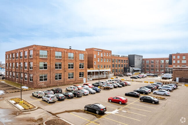
Property Record
807 Broadway St Ne, Minneapolis, MN 55413


Current Lease Availabilities
NEARBY LISTINGS FOR SALE OR LEASE
Property Detail
807 Broadway St Ne
14-029-24-14-0004
Auditors Subd. No. 004
Commercialnec
A AUDITORS SUBD. NO. 004 TRACTS A AND B REG LAND SURVEY NO 70 AND THAT PART OF AUD SUBD NO 4 LYING S OF REG LAND SURVEY NO 70 EX PART TAKEN FOR STREET INCL ADJ 4.5 FT OF T 319.00 X 564.00
X
Hennepin
27053C0357F
Minnesota
2024
4.07 AC
2024
Suburban St Paul
102500
Minneapolis/St Paul
209,524 SF
Minneapolis-St. Paul-Bloomington, MN-WI
DEMOGRAPHICS near 807 Broadway St Ne
1 Mile
3 Mile
5 Mile
2024 Total Population
25,112
203,286
459,527
2029 Population
24,677
200,752
453,409
Pop Growth 2024-2029
(1.73%)
(1.25%)
(1.33%)
Average Age
38
35
37
2024 Total Households
12,796
90,295
200,850
HH Growth 2024-2029
(1.49%)
(1.07%)
(1.29%)
Median Household Inc
$70,164
$58,397
$65,989
Avg Household Size
1.90
2.00
2.10
2024 Avg HH Vehicles
1.00
1.00
1.00
Median Home Value
$347,019
$302,290
$293,625
Median Year Built
1964
1971
1961
Nearby Places
Map Layers
Map Styles
 Street
 Aerial
- Restaurants
- Banks
- Shops
- Fitness
- Groceries
PUBLIC TRANSPORTATION
COMMUTER RAIL
Target Field Station (Northstar Corridor - Northstar Commuter Rail)
DRIVE
WALK
Distance
Target Field Station (Northstar Corridor - Northstar Commuter Rail)
8 min
2.5 mi
Fridley Station (Northstar Corridor - Northstar Commuter Rail)
DRIVE
WALK
Distance
Fridley Station (Northstar Corridor - Northstar Commuter Rail)
14 min
7.1 mi
AIRPORT
Minneapolis-St Paul International/Wold-Chamberlain
DRIVE
WALK
Distance
Minneapolis-St Paul International/Wold-Chamberlain
25 min
12.6 mi
Freight Ports
Port Milwaukee
DRIVE
WALK
Distance
Port Milwaukee
379 min
341.1 mi
Nearby Properties
Address
Land Use
TOTAL SIZE
Lot Size
Zoning
Address
Land Use
TOTAL SIZE
Lot Size
Zoning
1,462,182 SF
1 AC
B4-2
Address
Land Use
TOTAL SIZE
Lot Size
Zoning
2,094,377 SF
2.10 AC
B4-2
Address
Land Use
TOTAL SIZE
Lot Size
Zoning
1,821,999 SF
2.51 AC
B4-2
Address
Land Use
TOTAL SIZE
Lot Size
Zoning
Address
Land Use
TOTAL SIZE
Lot Size
Zoning
1,934,403 SF
1.67 AC
B4-2
Address
Land Use
TOTAL SIZE
Lot Size
Zoning
1,021,060 SF
1.71 AC
B4S-2
Address
Land Use
TOTAL SIZE
Lot Size
Zoning
2,282,334 SF
3.25 AC
B4-2
Address
Land Use
TOTAL SIZE
Lot Size
Zoning
1,054,492 SF
1.70 AC
B4-1
Address
Land Use
TOTAL SIZE
Lot Size
Zoning
495,632 SF
1.72 AC
C1
Address
Land Use
TOTAL SIZE
Lot Size
Zoning
1,208,190 SF
1.20 AC
B4-2
Address
Land Use
TOTAL SIZE
Lot Size
Zoning
621,608 SF
1.03 AC
B4-2
Address
Land Use
TOTAL SIZE
Lot Size
Zoning
458,470 SF
1.18 AC
OR3
Address
Land Use
TOTAL SIZE
Lot Size
Zoning
907,129 SF
1.65 AC
B4-1
Address
Land Use
TOTAL SIZE
Lot Size
Zoning
442,731 SF
0.97 AC
B4S-2
Address
Land Use
TOTAL SIZE
Lot Size
Zoning
1,044,454 SF
1.08 AC
B4-2
Address
Land Use
TOTAL SIZE
Lot Size
Zoning
1,261,574 SF
2.52 AC
B4-2
Address
Land Use
TOTAL SIZE
Lot Size
Zoning
695,624 SF
3.67 AC
C2
Address
Land Use
TOTAL SIZE
Lot Size
Zoning
2.67 AC
C3A
Address
Land Use
TOTAL SIZE
Lot Size
Zoning
615,172 SF
1.98 AC
I1
Address
Land Use
TOTAL SIZE
Lot Size
Zoning
1 SF
69.72 AC
I3
Address
Land Use
TOTAL SIZE
Lot Size
Zoning
722,423 SF
1.33 AC
B4-2
Address
Land Use
TOTAL SIZE
Lot Size
Zoning
1,424,796 SF
1.13 AC
B4-1
Address
Land Use
TOTAL SIZE
Lot Size
Zoning
577,656 SF
2.92 AC
C3A
Address
Land Use
TOTAL SIZE
Lot Size
Zoning
557,654 SF
3.15 AC
C2
Address
Land Use
TOTAL SIZE
Lot Size
Zoning
478,616 SF
2.28 AC
C2
Address
Land Use
TOTAL SIZE
Lot Size
Zoning
513,403 SF
0.73 AC
C2
Address
Land Use
TOTAL SIZE
Lot Size
Zoning
1,235,416 SF
1.12 AC
B4-2
Address
Land Use
TOTAL SIZE
Lot Size
Zoning
323,404 SF
2.54 AC
B4S-2
Address
Land Use
TOTAL SIZE
Lot Size
Zoning
561,603 SF
1 AC
B4N
Address
Land Use
TOTAL SIZE
Lot Size
Zoning
403,792 SF
2.51 AC
B4N
The World's #1 Commercial Real Estate Marketplace
Connect with us
© 2026 CoStar Group
The information above has been obtained from sources believed reliable. While we do not doubt its accuracy we have not verified it and make no guarantee, warranty or representation about it. It is your responsibility to independently confirm its accuracy and completeness. Any projections, opinions, assumptions, or estimates used are for example only and do not represent the current or future performance of the property. The value of this transaction to you depends on tax and other factors which should be evaluated by your tax, financial, and legal advisors. You and your advisors should conduct a careful, independent investigation of the property to determine to your satisfaction the suitability of the property for your needs.