Property Record
807 E Main St, Molalla, OR 97038
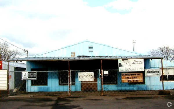

Property Detail
807 E Main St
Portland-Vancouver-Hillsboro, OR-WA
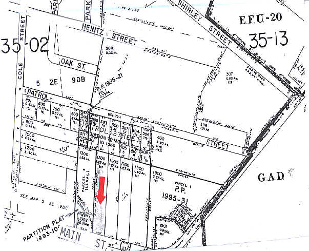
SECTION 09 TOWNSHIP 5S RANGE 2E QUARTER D TAX LOT 01500
01100061
Clackamas
Commercialbuilding
Oregon
C2
1500
B and X Area of moderate flood hazard, usually the area between the limits of the 100-year and 500-year floods.
2.52 AC
0
SE Outlying
2025
Portland
023902
NEARBY LISTINGS FOR SALE OR LEASE
DEMOGRAPHICS near 807 E Main St
1 mile
3 mile
5 mile
2024 Total Population
4,813
12,938
16,799
2029 Population
4,823
12,985
16,741
Pop Growth 2024-2029
+ 0.21%
+ 0.36%
(0.35%)
Average Age
39
38
40
2024 Total Households
1,699
4,537
5,920
HH Growth 2024-2029
+ 0.12%
+ 0.29%
(0.42%)
Median Household Inc
$88,802
$91,410
$94,060
Avg Household Size
2.70
2.80
2.80
2024 Avg HH Vehicles
2.00
2.00
2.00
Median Home Value
$435,960
$449,582
$481,877
Median Year Built
1985
1991
1989
Nearby Places
Map Layers
Map Styles
 Street
 Aerial
Transit
 Traffic
 Biking
Places
Listings with unknown addresses are not visible on the map
- Restaurants
- Banks
- Shops
- Fitness
- Groceries
Nearby Properties
Address
Land Use
TOTAL SIZE
Lot Size
Zoning
Address
Land Use
TOTAL SIZE
Lot Size
Zoning
13 AC
C2
Address
Land Use
TOTAL SIZE
Lot Size
Zoning
Address
Land Use
TOTAL SIZE
Lot Size
Zoning
2,134 SF
4.43 AC
R3
Address
Land Use
TOTAL SIZE
Lot Size
Zoning
3,624 SF
2.95 AC
R3
Address
Land Use
TOTAL SIZE
Lot Size
Zoning
1,492 SF
4.11 AC
R3
Address
Land Use
TOTAL SIZE
Lot Size
Zoning
1,956 SF
5.75 AC
R3
Address
Land Use
TOTAL SIZE
Lot Size
Zoning
4 AC
R3
Address
Land Use
TOTAL SIZE
Lot Size
Zoning
1.59 AC
C1
Address
Land Use
TOTAL SIZE
Lot Size
Zoning
Address
Land Use
TOTAL SIZE
Lot Size
Zoning
25.76 AC
M2
Address
Land Use
TOTAL SIZE
Lot Size
Zoning
Address
Land Use
TOTAL SIZE
Lot Size
Zoning
2 AC
C1
Address
Land Use
TOTAL SIZE
Lot Size
Zoning
1,578 SF
3.92 AC
C2
Address
Land Use
TOTAL SIZE
Lot Size
Zoning
Address
Land Use
TOTAL SIZE
Lot Size
Zoning
3.65 AC
R3
Address
Land Use
TOTAL SIZE
Lot Size
Zoning
2.60 AC
C2
Address
Land Use
TOTAL SIZE
Lot Size
Zoning
1 SF
8 AC
M1
Address
Land Use
TOTAL SIZE
Lot Size
Zoning
Address
Land Use
TOTAL SIZE
Lot Size
Zoning
15.78 AC
RRFF5
Address
Land Use
TOTAL SIZE
Lot Size
Zoning
1,600 SF
1.70 AC
M2
Address
Land Use
TOTAL SIZE
Lot Size
Zoning
3 AC
C1
Address
Land Use
TOTAL SIZE
Lot Size
Zoning
3.73 AC
M2
Address
Land Use
TOTAL SIZE
Lot Size
Zoning
1,155 SF
1.14 AC
C2
Address
Land Use
TOTAL SIZE
Lot Size
Zoning
2.50 AC
R3
Address
Land Use
TOTAL SIZE
Lot Size
Zoning
9.13 AC
M2
Address
Land Use
TOTAL SIZE
Lot Size
Zoning
2.76 AC
M1
Address
Land Use
TOTAL SIZE
Lot Size
Zoning
1,266 SF
4 AC
R3
Address
Land Use
TOTAL SIZE
Lot Size
Zoning
2 AC
R3
The World's #1 Commercial Real Estate Marketplace
Connect with us
© 2026 CoStar Group
The information above has been obtained from sources believed reliable. While we do not doubt its accuracy we have not verified it and make no guarantee, warranty or representation about it. It is your responsibility to independently confirm its accuracy and completeness. Any projections, opinions, assumptions, or estimates used are for example only and do not represent the current or future performance of the property. The value of this transaction to you depends on tax and other factors which should be evaluated by your tax, financial, and legal advisors. You and your advisors should conduct a careful, independent investigation of the property to determine to your satisfaction the suitability of the property for your needs.