Property Record
807 Las Cimas Pkwy, Austin, TX 78746
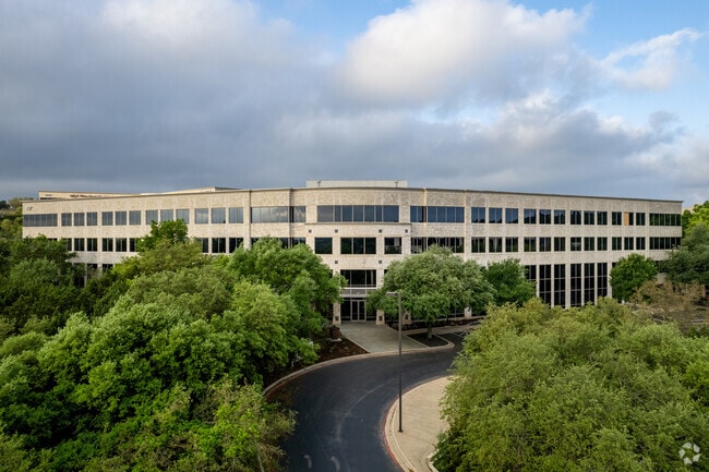


Property Detail
807 Las Cimas Pkwy
Austin-Round Rock-San Marcos, TX
LOT 1A BLK A LAS CIMAS OFFICE PARK AMENDED PLAT OF BLK A OF
455195
TRAVIS
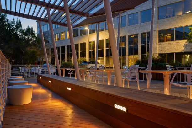
Officebuilding
Texas
B and X Area of moderate flood hazard, usually the area between the limits of the 100-year and 500-year floods.
1a
2025
3.45 AC
2025
Southwest
001917
Austin
156,682 SF
NEARBY LISTINGS FOR SALE OR LEASE
DEMOGRAPHICS near 807 Las Cimas Pkwy
1 mile
3 mile
5 mile
2025 Total Population
4,562
31,916
147,766
2030 Population
4,701
33,194
154,422
Pop Growth 2025-2030
+ 3.05%
+ 4.00%
+ 4.50%
Average Age
43
43
40
2025 Total Households
1,550
12,277
67,805
HH Growth 2025-2030
+ 3.81%
+ 4.81%
+ 5.27%
Median Household Inc
$226,816
$193,045
$124,968
Avg Household Size
2.90
2.50
2.10
2025 Avg HH Vehicles
2.00
2.00
2.00
Median Home Value
$1,095,097
$1,097,142
$1,032,407
Median Year Built
1985
1992
1995
Nearby Places
Map Layers
Map Styles
 Street
 Aerial
Layers
 Traffic
 Biking
Places
Listings with unknown addresses are not visible on the map
- Restaurants
- Banks
- Shops
- Fitness
- Groceries
PUBLIC TRANSPORTATION
COMMUTER RAIL
Austin (Texas Eagle - Amtrak)
Drive
Walk
Distance
Austin (Texas Eagle - Amtrak)
13 min
7.9 mi
AIRPORT
Austin-Bergstrom International
Drive
Walk
Distance
Austin-Bergstrom International
28 min
15.5 mi
Freight Ports
Calhoun Port
Drive
Walk
Distance
Calhoun Port
194 min
159.0 mi
SALE & LEASE HISTORY
LISTING DATE
SALE/LEASE

Sep 28, 2016
For Lease
Sep 26, 2016
For Lease
Sep 26, 2016
For Lease
Sep 26, 2016
For Lease
Sep 26, 2016
For Lease
Mar 28, 2018
For Lease
Mar 26, 2019
For Lease
Jul 19, 2021
For Lease
Feb 28, 2020
For Lease
Dec 07, 2022
For Lease
Nearby Properties
Address
Land Use
TOTAL SIZE
Lot Size
Zoning
Address
Land Use
TOTAL SIZE
Lot Size
Zoning
632.50 AC
Address
Land Use
TOTAL SIZE
Lot Size
Zoning
46.98 AC
Address
Land Use
TOTAL SIZE
Lot Size
Zoning
599,648 SF
16.83 AC
Address
Land Use
TOTAL SIZE
Lot Size
Zoning
34.03 AC
Address
Land Use
TOTAL SIZE
Lot Size
Zoning
617,120 SF
53.40 AC
Address
Land Use
TOTAL SIZE
Lot Size
Zoning
35.28 AC
Address
Land Use
TOTAL SIZE
Lot Size
Zoning
551,881 SF
34.85 AC
Address
Land Use
TOTAL SIZE
Lot Size
Zoning
456,600 SF
44.89 AC
Address
Land Use
TOTAL SIZE
Lot Size
Zoning
377,128 SF
14.99 AC
Address
Land Use
TOTAL SIZE
Lot Size
Zoning
221,273 SF
48.10 AC
Address
Land Use
TOTAL SIZE
Lot Size
Zoning
290,107 SF
18.62 AC
Address
Land Use
TOTAL SIZE
Lot Size
Zoning
438,544 SF
61.37 AC
Address
Land Use
TOTAL SIZE
Lot Size
Zoning
217,490 SF
19.03 AC
Address
Land Use
TOTAL SIZE
Lot Size
Zoning
344,392 SF
24.53 AC
Address
Land Use
TOTAL SIZE
Lot Size
Zoning
71,812 SF
9.18 AC
Address
Land Use
TOTAL SIZE
Lot Size
Zoning
210,000 SF
12.74 AC
Address
Land Use
TOTAL SIZE
Lot Size
Zoning
220,688 SF
21.85 AC
Address
Land Use
TOTAL SIZE
Lot Size
Zoning
149,610 SF
12.67 AC
Address
Land Use
TOTAL SIZE
Lot Size
Zoning
12.17 AC
Address
Land Use
TOTAL SIZE
Lot Size
Zoning
135,103 SF
20.58 AC
Address
Land Use
TOTAL SIZE
Lot Size
Zoning
170,058 SF
28.28 AC
Address
Land Use
TOTAL SIZE
Lot Size
Zoning
251,946 SF
11.59 AC
Address
Land Use
TOTAL SIZE
Lot Size
Zoning
102.28 AC
Address
Land Use
TOTAL SIZE
Lot Size
Zoning
153,404 SF
13.60 AC
Address
Land Use
TOTAL SIZE
Lot Size
Zoning
12.45 AC
Address
Land Use
TOTAL SIZE
Lot Size
Zoning
130,476 SF
13.60 AC
Address
Land Use
TOTAL SIZE
Lot Size
Zoning
149,352 SF
20.99 AC
Address
Land Use
TOTAL SIZE
Lot Size
Zoning
161,450 SF
19.03 AC
Address
Land Use
TOTAL SIZE
Lot Size
Zoning
110,911 SF
13.37 AC
The World's #1 Commercial Real Estate Marketplace
Connect with us
© 2026 CoStar Group
The information above has been obtained from sources believed reliable. While we do not doubt its accuracy we have not verified it and make no guarantee, warranty or representation about it. It is your responsibility to independently confirm its accuracy and completeness. Any projections, opinions, assumptions, or estimates used are for example only and do not represent the current or future performance of the property. The value of this transaction to you depends on tax and other factors which should be evaluated by your tax, financial, and legal advisors. You and your advisors should conduct a careful, independent investigation of the property to determine to your satisfaction the suitability of the property for your needs.