Property Record
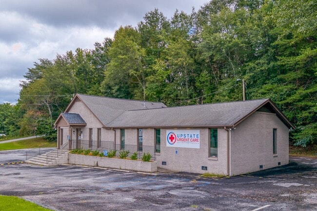
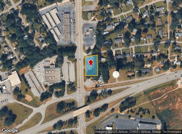
807 S Pendleton St, Easley, SC 29640
This Property Is For Sale
Property Detail
807 S Pendleton St
Greenville-Anderson-Greer, SC
Cates Subdivision #4
5019-20-90-4256
LOTS 1 8 E/SIDE S PENDLETON ST
Dentalbldg
Pickens
X
South Carolina
45077C0303D
1,8
2025
0.62 AC
2025
Outlying Pickens County
010804
Greenville/Spartanburg
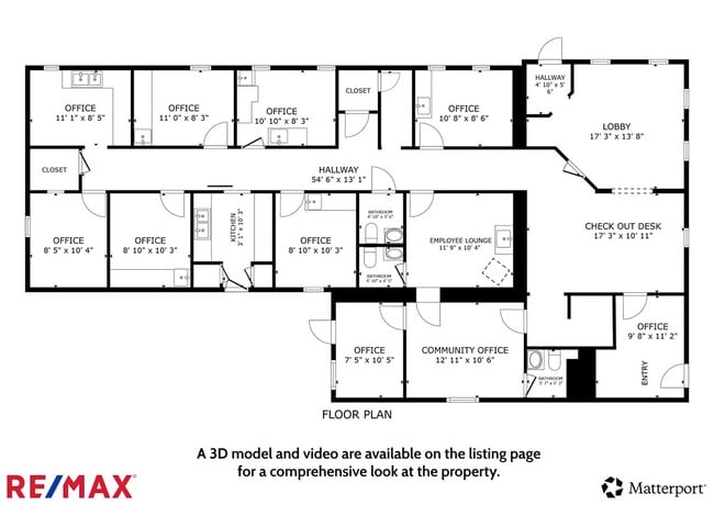
1,572 SF
NEARBY LISTINGS FOR SALE OR LEASE
DEMOGRAPHICS near 807 S Pendleton St
1 mile
3 mile
5 mile
2024 Total Population
6,255
31,652
52,464
2029 Population
6,632
33,295
55,034
Pop Growth 2024-2029
+ 6.03%
+ 5.19%
+ 4.90%
Average Age
40
41
41
2024 Total Households
2,750
13,169
21,112
HH Growth 2024-2029
+ 6.07%
+ 5.27%
+ 4.96%
Median Household Inc
$34,676
$50,878
$57,032
Avg Household Size
2.20
2.40
2.40
2024 Avg HH Vehicles
2.00
2.00
2.00
Median Home Value
$136,433
$171,254
$186,171
Median Year Built
1976
1984
1989
Nearby Places
Map Layers
Map Styles
 Street
 Aerial
Transit
 Traffic
 Biking
Places
Listings with unknown addresses are not visible on the map
- Restaurants
- Banks
- Shops
- Fitness
- Groceries
PUBLIC TRANSPORTATION
AIRPORT
Greenville Spartanburg International
Drive
Walk
Distance
Greenville Spartanburg International
42 min
28.3 mi
Nearby Properties
Address
Land Use
TOTAL SIZE
Lot Size
Zoning
Address
Land Use
TOTAL SIZE
Lot Size
Zoning
81,245 SF
8.49 AC
GC
Address
Land Use
TOTAL SIZE
Lot Size
Zoning
2,291 SF
6.44 AC
GR2
Address
Land Use
TOTAL SIZE
Lot Size
Zoning
21.71 AC
GR2
Address
Land Use
TOTAL SIZE
Lot Size
Zoning
19,164 SF
3.22 AC
GC
Address
Land Use
TOTAL SIZE
Lot Size
Zoning
9,800 SF
5.94 AC
R10
Address
Land Use
TOTAL SIZE
Lot Size
Zoning
24,362 SF
3.84 AC
GENERAL CO
Address
Land Use
TOTAL SIZE
Lot Size
Zoning
19,088 SF
3 AC
CC
Address
Land Use
TOTAL SIZE
Lot Size
Zoning
10,906 SF
2.59 AC
CORE COMME
Address
Land Use
TOTAL SIZE
Lot Size
Zoning
42,413 SF
6.17 AC
GR1
Address
Land Use
TOTAL SIZE
Lot Size
Zoning
3.60 AC
CORE COMME
Address
Land Use
TOTAL SIZE
Lot Size
Zoning
3,344 SF
3.04 AC
GR2
Address
Land Use
TOTAL SIZE
Lot Size
Zoning
44,601 SF
3 AC
Address
Land Use
TOTAL SIZE
Lot Size
Zoning
162.06 AC
R10
Address
Land Use
TOTAL SIZE
Lot Size
Zoning
177,695 SF
20.43 AC
Address
Land Use
TOTAL SIZE
Lot Size
Zoning
16.29 AC
GENERAL CO
Address
Land Use
TOTAL SIZE
Lot Size
Zoning
4,200 SF
0.98 AC
GC
Address
Land Use
TOTAL SIZE
Lot Size
Zoning
13.75 AC
GC
Address
Land Use
TOTAL SIZE
Lot Size
Zoning
6,670 SF
4 AC
GR2
Address
Land Use
TOTAL SIZE
Lot Size
Zoning
1,532 SF
9.03 AC
GR2
Address
Land Use
TOTAL SIZE
Lot Size
Zoning
3,044 SF
2 AC
GENERAL RE
Address
Land Use
TOTAL SIZE
Lot Size
Zoning
3,325 SF
16.01 AC
R10
Address
Land Use
TOTAL SIZE
Lot Size
Zoning
5,427 SF
1.34 AC
Address
Land Use
TOTAL SIZE
Lot Size
Zoning
49,803 SF
18.36 AC
GC
Address
Land Use
TOTAL SIZE
Lot Size
Zoning
3,250 SF
0.07 AC
GENERAL RE
Address
Land Use
TOTAL SIZE
Lot Size
Zoning
5,000 SF
0.12 AC
CORE COMME
Address
Land Use
TOTAL SIZE
Lot Size
Zoning
6,082 SF
1.63 AC
R6
Address
Land Use
TOTAL SIZE
Lot Size
Zoning
220,956 SF
16.80 AC
GENERAL CO
Address
Land Use
TOTAL SIZE
Lot Size
Zoning
30,000 SF
3.30 AC
Address
Land Use
TOTAL SIZE
Lot Size
Zoning
4,450 SF
1.28 AC
MED MEDICA
Address
Land Use
TOTAL SIZE
Lot Size
Zoning
3,867 SF
1.22 AC
CORE COMME
The World's #1 Commercial Real Estate Marketplace
Connect with us
© 2026 CoStar Group
The information above has been obtained from sources believed reliable. While we do not doubt its accuracy we have not verified it and make no guarantee, warranty or representation about it. It is your responsibility to independently confirm its accuracy and completeness. Any projections, opinions, assumptions, or estimates used are for example only and do not represent the current or future performance of the property. The value of this transaction to you depends on tax and other factors which should be evaluated by your tax, financial, and legal advisors. You and your advisors should conduct a careful, independent investigation of the property to determine to your satisfaction the suitability of the property for your needs.